Category:Poland in the 1st century
Jump to navigation
Jump to search
Countries of Europe: Albania · Armenia‡ · Austria · Belarus · Belgium · Bosnia and Herzegovina · Bulgaria · Croatia · Czech Republic · Denmark · France‡ · Germany · Greece · Hungary · Italy · Netherlands‡ · Poland · Portugal‡ · Romania · Russia‡ · Serbia · Slovakia · Spain‡ · Sweden · Switzerland · Turkey‡ · Ukraine
‡: partly located in Europe
‡: partly located in Europe

Subcategories
This category has the following 28 subcategories, out of 28 total.
Media in category "Poland in the 1st century"
The following 28 files are in this category, out of 28 total.
-
 0009 T. Wandalische Funde aus Waldkarpaten 2-4. Jh. n. Chr. 1. 1. 1.JPG 857 × 629; 342 KB
-
 02023 AVCISSA breastpin, elements of the equipment from the so-called ducal tomb.jpg 2,163 × 1,425; 260 KB
-

-

-

-

-
 1657 Jansson Map of Germany (Germania) - Geographicus - Germaniae-jansson-1657.jpg 3,500 × 2,811; 3.38 MB
-
 1832 Delamarche Map of Germany in Roman Times - Geographicus - Germany-d-32.jpg 3,000 × 2,537; 2.01 MB
-
 Ancient Germania - New York, Harper and Brothers 1849.jpg 1,964 × 1,619; 841 KB
-
 Blaeu 1645 - Germaniae veteris typus.jpg 3,635 × 3,046; 1.64 MB
-
 Celtic sword heath showing dragon 50 AD, Cracow, photo by Silar.jpg 2,220 × 3,076; 2.44 MB
-
 Celts.svg 1,068 × 891; 322 KB
-
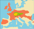
 Europa Germanen 50 n Chr-gl.svg 1,004 × 699; 602 KB
-
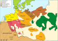
 Europa Germanen 50 n Chr-pt.svg 1,176 × 819; 418 KB
-
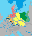
 Europa Germanen 50 n Chr.svg 941 × 655; 710 KB
-
 Germanic dialects ca. AD 1 with Arabic color key.jpg 419 × 582; 61 KB
-
 Germanic dialects ca. AD 1.png 2,067 × 2,312; 776 KB
-
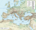
 Imperium Romanum Germania.png 700 × 491; 203 KB
-
 Map of Europe according to Strabo.jpg 485 × 385; 152 KB
-
 Roman Empire 125 general map-zh.png 2,732 × 2,271; 6.07 MB
-
 Roman Empire 125 general map-zh.svg 2,732 × 2,271; 6.55 MB
-
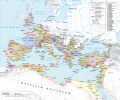
 Roman Empire 125 general map.SVG 2,186 × 1,817; 1.77 MB
-
 Roman Empire 125 political map-de.svg 2,186 × 1,817; 6.32 MB
-
 Roman Empire 125 political map-zh.png 2,049 × 1,703; 2.99 MB
-
 Roman Empire 125 political map-zh.svg 2,732 × 2,271; 2.02 MB
-
 Roman Empire 125 political map.png 2,186 × 1,817; 3.21 MB
-
 Roman Empire 125 political map.svg 2,186 × 1,817; 3.25 MB
-
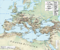
 Roman Empire 125.png 2,186 × 1,817; 4.43 MB


_-_Geographicus_-_Germaniae-jansson-1657.jpg)


