Category:Polruan Blockhouse
Jump to navigation
Jump to search
This is a category about listed building number 1329297. |
| Object location | | View all coordinates using: OpenStreetMap |
|---|
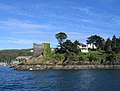
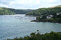
Tudor fort at entrance to Fowey River in Lanteglos, Cornwall, England, UK  | |||||
| Upload media | |||||
| Instance of |
| ||||
|---|---|---|---|---|---|
| Location | Polruan, Lanteglos, Cornwall, South West England, England | ||||
| Heritage designation |
| ||||
 | |||||
Media in category "Polruan Blockhouse"
The following 7 files are in this category, out of 7 total.
-

-
 Fowey Blockhouse - geograph.org.uk - 1131916.jpg 426 × 640; 60 KB
-
 Fowey Estuary and Polruan Blockhouse.jpg 3,644 × 2,737; 3.39 MB
-
 Fowey Harbour Blockhouse - geograph.org.uk - 166841.jpg 640 × 486; 248 KB
-
 Lanteglos, Polruan Blockhouse - geograph.org.uk - 1403065.jpg 640 × 427; 400 KB
-
 Polruan blockhouse.jpg 2,881 × 1,867; 2.72 MB
-
 Upriver from Polruan Blockhouse - geograph.org.uk - 480405.jpg 433 × 640; 75 KB


