Category:Rohr (Mittelfranken)
Jump to navigation
Jump to search
municipality of Germany _1699.jpg) _COA.svg) _1696.jpg)  | |||||
| Upload media | |||||
| Instance of |
| ||||
|---|---|---|---|---|---|
| Part of |
| ||||
| Location | Roth, Middle Franconia, Bavaria, Germany | ||||
| Head of government |
| ||||
| Population |
| ||||
| Area |
| ||||
| Elevation above sea level |
| ||||
| Different from | |||||
| official website | |||||
 | |||||
Subcategories
This category has the following 5 subcategories, out of 5 total.
A
Media in category "Rohr (Mittelfranken)"
The following 14 files are in this category, out of 14 total.
-
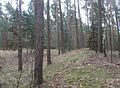 Abschnittswall Kottensdorf.jpg 1,600 × 1,176; 810 KB
-
 Brunnen mit Taubenskulptur - panoramio.jpg 1,859 × 1,337; 773 KB
-
 DEU Rohr (Mittelfranken) COA.svg 979 × 1,068; 14 KB
-
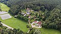 Förle.jpg 3,975 × 2,236; 7.67 MB
-
 Rohr (Mittelfranken) 1694.jpg 3,039 × 1,556; 1.09 MB
-
 Rohr (Mittelfranken) 1696.jpg 3,039 × 2,014; 1.33 MB
-
 Rohr (Mittelfranken) 1699.jpg 3,039 × 2,014; 1.2 MB
-
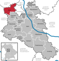
 Rohr im Lk Roth.png 390 × 391; 18 KB
-
 Rohr in RH.svg 592 × 607; 1.05 MB
-
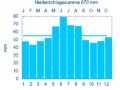 ROHR MFR DECHENDORF nieder.png 480 × 360; 5 KB
-
 ROHR MFR DECHENDORF nieder.svg 512 × 427; 21 KB
-
 Rohr1.JPG 3,264 × 2,176; 1.09 MB
-
 Scheune Rohr Regelsbach 9422.jpg 4,928 × 3,264; 10.24 MB
-
 Wappen von Rohr.png 1,050 × 1,120; 31 KB


_1694.jpg)


