Category:SVG maps of Assam
Jump to navigation
Jump to search
States of India: Andhra Pradesh · Arunachal Pradesh · Assam · Bihar · Chhattisgarh · Goa · Gujarat · Haryana · Himachal Pradesh · Jharkhand · Karnataka · Kerala · Madhya Pradesh · Maharashtra · Manipur · Meghalaya · Mizoram · Nagaland · Odisha · Punjab · Rajasthan · Sikkim · Tamil Nadu · Telangana · Tripura · Uttar Pradesh · Uttarakhand · West Bengal
Union territories: Andaman and Nicobar Islands · Chandigarh · Dadra and Nagar Haveli and Daman and Diu · Delhi · Jammu and Kashmir · Ladakh · Lakshadweep · Puducherry
Former states of India: Jammu and Kashmir ·
Former union territories:
Union territories: Andaman and Nicobar Islands · Chandigarh · Dadra and Nagar Haveli and Daman and Diu · Delhi · Jammu and Kashmir · Ladakh · Lakshadweep · Puducherry
Former states of India: Jammu and Kashmir ·
Former union territories:
Subcategories
This category has only the following subcategory.
Media in category "SVG maps of Assam"
The following 52 files are in this category, out of 52 total.
-
 2012 Assam Violence map as.svg 419 × 565; 314 KB
-
 2012 Assam Violence map.svg 419 × 565; 317 KB
-
 2024 NDA Alliance Lok Sabha Seat Sharing Assam.svg 2,831 × 2,112; 294 KB
-
 Assam 1950-hu.svg 703 × 655; 76 KB
-
 Assam 1950.svg 703 × 655; 77 KB
-
 Assam 1951 ml.svg 606 × 615; 1.18 MB
-
 Assam 1951-bn.svg 606 × 615; 1.18 MB
-
 Assam 1951-gu.svg 606 × 615; 1.12 MB
-
 Assam 1951-hi.svg 606 × 615; 1.16 MB
-
 Assam 1951-kn.svg 568 × 577; 1.18 MB
-
 Assam 1951-mr.svg 606 × 615; 1.16 MB
-
 Assam 1951-pa.svg 606 × 615; 1.1 MB
-
 Assam 1951-te.svg 606 × 615; 1.16 MB
-
 Assam 1951.svg 606 × 615; 2.25 MB
-
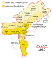 Assam 1960.svg 600 × 675; 51 KB
-
 Assam 1970.svg 606 × 615; 2.98 MB
-
 Assam locator map.svg 2,393 × 1,956; 264 KB
-
 Assam map for WLM-IN.svg 678 × 504; 101 KB
-
 Assam protected areas map-blank.svg 2,393 × 1,956; 417 KB
-
 Assam Wahlkreise Lok Sabha.svg 679 × 507; 615 KB
-
 Assam Wikivoyage map.svg 1,414 × 978; 921 KB
-
 Assam-districts-2001 as.svg 631 × 530; 212 KB
-
 Assam-districts-2001 ml.svg 631 × 530; 214 KB
-
 Assam-districts-2001-bn.svg 631 × 530; 215 KB
-
 Assam-districts-2001-gu.svg 631 × 530; 212 KB
-
 Assam-districts-2001-hi.svg 631 × 530; 214 KB
-
 Assam-districts-2001-kn.svg 631 × 530; 218 KB
-
 Assam-districts-2001-mr.svg 631 × 530; 168 KB
-
 Assam-districts-2001-ne.svg 631 × 530; 219 KB
-
 Assam-districts-2001-pa.svg 631 × 530; 169 KB
-
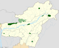
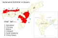 Autonome Distrikte Assam.svg 1,005 × 660; 396 KB
-
 Bodoland Territorial Area Districts as.svg 1,005 × 660; 400 KB
-
 Bodoland Territorial Area Districts.svg 1,005 × 660; 400 KB
-
 Dima Hasao und Karbi Anglong Distrikte.svg 1,005 × 660; 416 KB
-
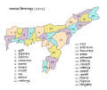
 Districts of Assam (2014).svg 765 × 633; 85 KB
-
 Distrikte von Assam.svg 765 × 633; 81 KB
-
 India Assam COVID-19 Death map.svg 765 × 633; 769 KB
-
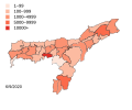 India Assam COVID-19 map.svg 765 × 633; 771 KB
-
 India Assam location map.svg 1,414 × 978; 580 KB
-
 India Assam locator map.svg 1,574 × 1,738; 836 KB
-
 India-ASSAM.svg 1,486 × 1,734; 427 KB
-
 Karimganj District Assam.svg 419 × 565; 323 KB
-
 Kaziranga-National-Park-map-as.svg 2,000 × 1,050; 165 KB
-
 Kaziranga-National-Park-map-blank.svg 2,000 × 1,050; 128 KB
-
 Kaziranga-National-Park-map-en-mod.svg 2,000 × 1,050; 155 KB
-
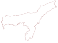 Map of Assam outline.svg 978 × 729; 243 KB
-
 Udalguri District Map.svg 512 × 480; 250 KB
-
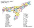
 Wahlkreise zur Vidhan Sabha von Assam-as.svg 978 × 729; 1.13 MB
-
 Wahlkreise zur Vidhan Sabha von Assam-bn.svg 978 × 729; 1.13 MB
-
 Wahlkreise zur Vidhan Sabha von Assam.svg 978 × 729; 673 KB
-
 আসামের বিধানসভা কেন্দ্র.svg 978 × 729; 1.11 MB
-
 আসামের লোকসভা কেন্দ্র.svg 679 × 507; 612 KB


.svg)


