Category:Schloss Radibor
Jump to navigation
Jump to search
| Object location | | View all coordinates using: OpenStreetMap |
|---|
castle in Radibor, Germany  | |||||
| Upload media | |||||
| Instance of | |||||
|---|---|---|---|---|---|
| Location | Radibor, Bautzen District, Saxony, Germany | ||||
| Street address |
| ||||
| Has part(s) | |||||
| Heritage designation | |||||
| Inception |
| ||||
 | |||||
Media in category "Schloss Radibor"
The following 25 files are in this category, out of 25 total.
-
 20060602050DR Radibor Rittergut Schloß.jpg 2,231 × 1,686; 3.07 MB
-
 20060602055DR Radibor Rittergut Schloß.jpg 2,252 × 1,722; 3.24 MB
-
 20060602070DR Radibor Rittergut Schloß.jpg 1,957 × 2,680; 3.54 MB
-
 20060602075DR Radibor Rittergut Schloß.jpg 2,560 × 1,917; 3.77 MB
-
 20060602080DR Radibor Rittergut Schloß.jpg 2,554 × 1,644; 2.84 MB
-
 20060602085DR Radibor Rittergut Schloß.jpg 2,560 × 1,917; 4.39 MB
-
 20060602090DR Radibor Rittergut Schloß.jpg 2,522 × 1,642; 3.43 MB
-
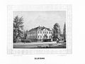 Album der Rittergüter und Schlösser im Königreiche Sachsen III b 007.jpg 3,696 × 2,777; 2.89 MB
-
 Radibor (Heise, 1850er).jpg 2,303 × 1,645; 2.65 MB
-
 Radibor - Am Schloß - Schloss Radibor 01 ies.jpg 5,616 × 3,744; 13.3 MB
-
 Radibor - Am Schloß - Schloss Radibor 02 ies.jpg 5,616 × 3,744; 8.43 MB
-
 Radibor - Am Schloß - Schloss Radibor 03 ies.jpg 5,616 × 3,744; 9.86 MB
-
 Radibor - Am Schloß - Schloss Radibor 04 ies.jpg 5,616 × 3,744; 9.7 MB
-
 Radibor - Am Schloß - Schloss Radibor 05 ies.jpg 5,616 × 3,744; 10.07 MB
-
 Radibor - Am Schloß - Schloss Radibor 06 ies.jpg 5,616 × 3,744; 9.05 MB
-
 Radibor - Am Schloß - Schloss Radibor 07 ies.jpg 5,616 × 3,744; 10.24 MB
-
 Radibor - Am Schloß - Schloss Radibor 08 ies.jpg 5,616 × 3,744; 14.86 MB
-
 Radibor-Gesindewohnhaus.jpg 3,291 × 2,194; 2.26 MB
-
 Radibor-Schloss-1.jpg 3,181 × 2,341; 2.58 MB
-
 Radibor-Schloss-2.jpg 3,445 × 2,584; 2.29 MB
-
 Radwor Hród (podrys 1).jpeg 420 × 554; 43 KB
-
 Radwor Hród (podrys 2).jpeg 477 × 567; 39 KB
-
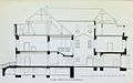 Radwor Hród (zarys).jpeg 574 × 360; 31 KB
-
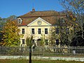
 Westside Manor House Radibor, Dez 2022.jpg 4,032 × 2,268; 3.24 MB
-
 Works on Manor House Radibor, Dez 2022.jpg 4,032 × 2,268; 3.79 MB


.jpg)


.jpeg)
.jpeg)
.jpeg)

