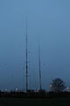
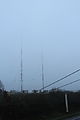
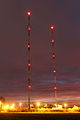
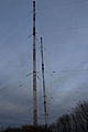
Category:Sender Heusweiler
Jump to navigation
Jump to search
| Object location | | View all coordinates using: OpenStreetMap |
|---|
architectural structure  | |||||
| Upload media | |||||
| Instance of |
| ||||
|---|---|---|---|---|---|
| Location | Heusweiler, Regionalverband Saarbrücken, Saarland, Germany | ||||
| Owned by | |||||
| Service entry |
| ||||
| Service retirement |
| ||||
| Start time |
| ||||
| End time |
| ||||
| Dissolved, abolished or demolished date |
| ||||
 | |||||
Media in category "Sender Heusweiler"
The following 81 files are in this category, out of 81 total.
-
 Abschirmgitter Autobahn Heusweiler28122015 1.JPG 4,692 × 3,128; 8.69 MB
-
 Abschirmgitter Autobahn Heusweiler28122015 2.JPG 4,389 × 2,926; 7.93 MB
-
 Abschirmnetz A8 16072014 Ost 1.JPG 3,867 × 2,578; 7.27 MB
-
 Abschirmnetz A8 16072014 Ost 2.JPG 3,981 × 2,654; 7.65 MB
-
 Abschirmnetz A8 16072014 West 1.JPG 4,167 × 2,778; 8.49 MB
-
 Abschirmnetz Autobahn Heusweiler22122015.JPG 4,980 × 3,320; 9.37 MB
-
 Abspannfundament Heusweiler 16072014.JPG 4,041 × 2,694; 6.47 MB
-
 Abspannfundament Westmast Heusweiler221222015 1.JPG 3,429 × 4,572; 11.92 MB
-
 Autobahn Heusweiler10122015.JPG 5,142 × 3,428; 9.66 MB
-
 Befestigung Abschirmnetz A8 16072014.JPG 2,654 × 3,981; 6.05 MB
-
 Faradayscher Käfig Heusweiler.JPG 3,072 × 2,304; 1.71 MB
-
 Fuss Reservesendemast Heusweiler28122015.JPG 4,698 × 2,639; 6.66 MB
-
 Fuss Westmast Heusweiler221222015 1.JPG 4,980 × 3,320; 9.23 MB
-
 Faradayscher Käfig Heusweiler 0685.jpg 2,560 × 1,920; 2.41 MB
-
 Sender Heusweiler.jpg 3,040 × 2,280; 3.61 MB
-
 Heusweiler-1422khz-1.jpg 778 × 519; 143 KB
-
 Heusweiler-1422khz-2.jpg 778 × 519; 117 KB
-
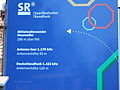 Informationstafel Sender Heusweiler10122015.JPG 4,508 × 3,381; 11.73 MB
-
 Informationstafel Sender Heusweiler22122015.JPG 5,091 × 3,394; 8.87 MB
-
 Ostmast Heusweiler10122015 1.JPG 3,202 × 4,803; 7.93 MB
-
 Ostmast Heusweiler22122015 1.JPG 3,381 × 4,508; 7.58 MB
-
 Ostmast Heusweiler22122015 2.JPG 3,326 × 4,989; 8.99 MB
-
 Ostmast Heusweiler22122015 3.JPG 3,320 × 4,980; 8.35 MB
-
 Ostmast Heusweiler22122015 4.JPG 3,201 × 4,268; 6.54 MB
-
 Ostmast Heusweiler28122015 1.JPG 3,442 × 5,163; 8.87 MB
-
 Ostmast Heusweiler28122015 2.JPG 3,310 × 4,965; 7.48 MB
-
 Pardunenabspannung Westmast Heusweiler10122015 1.JPG 3,220 × 4,830; 12.22 MB
-
 Pardunenisolator Reservesendemast Heusweiler22122015.JPG 3,465 × 2,310; 4.37 MB
-
 Pardunenisolator Westmast Heusweiler10122015 1.JPG 4,944 × 3,296; 9.09 MB
-
 Pardunenisolator Westmast Heusweiler221222015 1.JPG 4,704 × 3,136; 7.91 MB
-
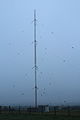
 Reservemast Heusweiler 16072014 1.JPG 2,736 × 4,104; 5.62 MB
-
 Reservemast Heusweiler 16072014 2.JPG 4,236 × 2,824; 6.1 MB
-
 Reservesendemast Heusweiler10122015 1.JPG 3,270 × 4,905; 8.36 MB
-
 Reservesendemast Heusweiler10122015 2.JPG 4,572 × 3,429; 8.79 MB
-
 Reservesendemast Heusweiler10122015 3.JPG 4,281 × 2,854; 7.23 MB
-
 Reservesendemast Heusweiler22122015 1.JPG 5,016 × 3,344; 8.46 MB
-
 Reservesendemast Heusweiler22122015 2.JPG 3,392 × 5,088; 8.74 MB
-
 Reservesendemast Heusweiler22122015 3.JPG 5,154 × 3,436; 10.08 MB
-
 Reservesendemast Heusweiler22122015 4.JPG 3,202 × 4,803; 7.94 MB
-
 Reservesendemast Heusweiler28122015 1.JPG 3,320 × 4,980; 8.08 MB
-
 Reservesendemast Heusweiler28122015 2.JPG 3,222 × 4,833; 7.75 MB
-
 Sendeanlage Heusweiler28122015.JPG 5,142 × 3,428; 9.77 MB
-
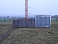
 Sendegebaeude Heusweiler10122015.JPG 4,980 × 3,320; 10.16 MB
-
 Sendegebaeude Heusweiler22122015.JPG 4,992 × 3,328; 8.88 MB
-
 Sender Heusweiler 16072014 1.JPG 4,104 × 2,736; 5.16 MB
-
 Sender Heusweiler 16072014 2.JPG 2,694 × 4,041; 4.6 MB
-
 Sender Heusweiler 16072014 3.JPG 2,694 × 4,041; 4.61 MB
-
 Sender Heusweiler 16072014 4.JPG 2,694 × 4,041; 4.82 MB
-
 Sender Heusweiler 16072014 5.JPG 2,654 × 3,981; 5.12 MB
-
 Sender Heusweiler 16072014 6.JPG 2,614 × 3,921; 5 MB
-
 Sender Heusweiler10122015 1.JPG 3,428 × 5,142; 8.71 MB
-
 Sender Heusweiler10122015 2.JPG 3,372 × 5,058; 9.92 MB
-
 Sender Heusweiler10122015 3.JPG 3,336 × 5,004; 9.1 MB
-
 Sender Heusweiler10122015 4.JPG 3,282 × 4,923; 8.6 MB
-
 Sender Heusweiler10122015 5.JPG 3,270 × 4,905; 7.67 MB
-
 Sender Heusweiler10122015 6.JPG 3,184 × 4,776; 7.52 MB
-
 Sender Heusweiler22122015 1.JPG 3,372 × 5,058; 7.83 MB
-
 Sender Heusweiler22122015 10.JPG 3,152 × 4,728; 7.54 MB
-
 Sender Heusweiler22122015 2.JPG 3,214 × 4,821; 7.91 MB
-
 Sender Heusweiler22122015 3.JPG 3,174 × 4,761; 8.67 MB
-
 Sender Heusweiler22122015 4.JPG 3,084 × 4,626; 8.6 MB
-
 Sender Heusweiler22122015 6.JPG 3,258 × 4,887; 8.15 MB
-
 Sender Heusweiler22122015 8.JPG 3,344 × 5,016; 8.99 MB
-
 Sender Heusweiler22122015 9.JPG 3,220 × 4,830; 8.13 MB
-
 Sender Heusweiler28122015 1.JPG 3,312 × 4,968; 9.37 MB
-
 Sender Heusweiler28122015 2.JPG 3,372 × 5,058; 10.96 MB
-
 Sender Heusweiler28122015 3.JPG 3,138 × 4,707; 8.54 MB
-
 Sender Heusweiler28122015 4.JPG 3,174 × 4,761; 9.35 MB
-
 Sender Heusweiler28122015 5.JPG 4,638 × 3,092; 6.46 MB
-
 Sender Heusweiler28122015 6.JPG 3,332 × 4,998; 8.09 MB
-
 Sender Heusweiler28122015 7.JPG 3,336 × 5,004; 8.52 MB
-
 Sender Heusweiler28122015 8.JPG 3,362 × 5,043; 9.23 MB
-
 Sender Heusweiler28122015 9.png 3,424 × 2,408; 8.57 MB
-
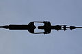
 Spitze Sendemast Heusweiler 16072014 1.JPG 2,736 × 4,104; 4.94 MB
-
 Spitze Sendemast Heusweiler 16072014 2.JPG 2,694 × 4,041; 4.53 MB
-
 Unterteil Sendemast Heusweiler 16072014 1.JPG 2,694 × 4,041; 5.32 MB
-
 Unterteil Sendemast Heusweiler 16072014 2.JPG 3,867 × 2,578; 4.45 MB
-
 Westmast Heusweiler221222015 2.JPG 3,320 × 4,980; 10.98 MB
-
 Westmast Heusweiler221222015 3.JPG 3,354 × 4,472; 7.04 MB
-
 Westmast Heusweiler221222015 4.JPG 3,376 × 5,064; 9.35 MB
-
 Westmast Heusweiler28122015 1.JPG 3,428 × 5,142; 9.3 MB


