Category:St Mary's Tower, Birkenhead Priory
Jump to navigation
Jump to search
| Object location | | View all coordinates using: OpenStreetMap |
|---|
This is a category about listed building number 1218757. |
part of the ruins of St Mary's church, Birkenhead Priory | |||||
| Upload media | |||||
| Instance of | |||||
|---|---|---|---|---|---|
| Part of | |||||
| Location |
| ||||
 | |||||
Subcategories
This category has the following 3 subcategories, out of 3 total.
Media in category "St Mary's Tower, Birkenhead Priory"
The following 8 files are in this category, out of 8 total.
-
 Birkenhead Priory, exterior.jpg 480 × 640; 60 KB
-
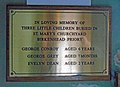 Children's memorial, Birkenhead Priory.jpg 3,762 × 2,736; 5.97 MB
-
 St Mary's Tower (31303224591).jpg 4,000 × 3,000; 3.07 MB
-
 St Mary's Tower at Birkenhead Priory ( 1).JPG 3,456 × 4,608; 3.18 MB
-
 St Mary's Tower at Birkenhead Priory (2).JPG 4,608 × 3,456; 3.21 MB
-
 St Mary's Tower, Birkenhead Priory 2017-1.jpg 2,667 × 4,550; 5.59 MB
-
 St Mary's Tower, Birkenhead Priory 2017-2.jpg 4,408 × 3,565; 5.93 MB
-
 Thetis plaque, St Mary's Tower, Birkenhead Priory.jpg 2,284 × 2,521; 3.13 MB


.jpg)
.JPG)
.JPG)


