Category:Suriname
Salti al navigilo
Salti al serĉilo
Landoj de Sudameriko: Argentino · Bolivio · Brazilo · Ĉilio · Ekvadoro · Gujano · Kolombio · Paragvajo · Peruo · Surinamo · Trinidado kaj Tobago‡ · Urugvajo · Venezuelo
Aliaj teritorioj: Arubo · Bonaire · Franca Gujano · Insuloj Falklandoj · Kuracao · Sud-Georgio kaj Sud-Sandviĉinsuloj
‡: parte situanta en Sudameriko
Aliaj teritorioj: Arubo · Bonaire · Franca Gujano · Insuloj Falklandoj · Kuracao · Sud-Georgio kaj Sud-Sandviĉinsuloj
‡: parte situanta en Sudameriko

| Category Suriname on sister projects: | |||||||||
|---|---|---|---|---|---|---|---|---|---|
Wikinews |
Commons
|
Wikivoyage | |||||||
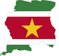
lando en Sud-Ameriko   | |||||
| Alŝuti plurmedion | |||||
| Prononco-registraĵo | |||||
|---|---|---|---|---|---|
| Estas |
| ||||
| Parto de | |||||
| Kulturo | |||||
| Loko |
| ||||
| Ĉefurbo | |||||
| Formo de registaro |
| ||||
| Leĝdona aŭtoritato | |||||
| Oficiala lingvo | |||||
| Himno | |||||
| Valuto |
| ||||
| Ŝtatestro |
| ||||
| Dato de fondo aŭ kreo |
| ||||
| Signifa okazaĵo |
| ||||
| Plej alta punkto |
| ||||
| Loĝantaro |
| ||||
| Areo |
| ||||
| Anstataŭigas |
| ||||
| Interreta domajno | |||||
| Alia ol | |||||
| oficiala retejo | |||||
 | |||||
English: Suriname is a country in South America.
Nederlands: Suriname is een land in het noorden van Zuid-Amerika.

Subkategorioj
Ĉi tiu kategorio havas la 16 jenajn subkategoriojn, el 16 entute.
Dosieroj en kategorio “Suriname”
La jenaj 57 dosieroj estas en ĉi tiu kategorio, el 57 entute.
-
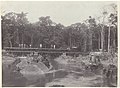 Aanleg van de Lawaspoorweg over de Witti Watra in Suriname, NG-2009-45-30.jpg 4 974 × 3 656; 2,27 MB
-
 Aldea Kawemhakan.png 487 × 346; 277 KB
-
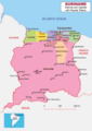
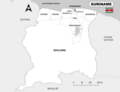 Alle districten van Suriname.png 7 920 × 6 120; 931 KB
-
 Apetina Foto.png 487 × 347; 398 KB
-
 Bakhuisspoorlijn.png 1 600 × 1 100; 338 KB
-
 Drie membraciden uit Suriname (IA biostor-13296).pdf 785 × 1 347, 5 paĝoj; 1,36 MB
-
 Block 52 Offshore Map Suriname (Oil and Gas).png 8 420 × 5 950; 1,22 MB
-
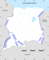 Border Rivers of Suriname.png 3 507 × 4 299; 704 KB
-
 Bruynzeelwoning Suriname.jpg 1 600 × 1 200; 329 KB
-
 District Brokopondo - Suriname - Location Map.png 7 920 × 6 120; 904 KB
-
 District Commewijne - Suriname - Location Map.png 7 920 × 6 120; 892 KB
-
 District Coronie - Suriname - Location Map.png 7 920 × 6 120; 891 KB
-
 District Marowijne - Suriname - Location Map.png 7 920 × 6 120; 894 KB
-
 District Nickerie - Suriname- Location Map.png 7 920 × 6 120; 891 KB
-
 District Para - Suriname - Location Map.png 7 920 × 6 120; 894 KB
-
 District Saramacca - Suriname - Location Map.png 7 920 × 6 120; 893 KB
-
 District Sipaliwini - Suriname - Location Map.png 7 920 × 6 120; 897 KB
-
 District Wanica - Suriname - Location Map.png 7 920 × 6 120; 889 KB
-
 Emission spéciale Rédemptoristes au Suriname.jpg 2 945 × 1 552; 1,37 MB
-
 Flag Map of Suriname.svg 827 × 791; 44 KB
-
 Fort Zeelandia Side view.jpg 1 280 × 1 280; 307 KB
-
 Grondwet van Suriname (1992).pdf 1 239 × 1 754, 45 paĝoj; 232 KB
-
 Guyana Map with Disputed Areas (Esequiba and Tigri).png 3 507 × 2 480; 534 KB
-

-
 Joop Vernooij.jpg 465 × 620; 85 KB
-
 Kaart van Suriname met betwiste Gebieden.png 5 802 × 5 950; 858 KB
-
 Map of Suriname showing Districts and the capital cities.svg 1 448 × 1 572; 330 KB
-
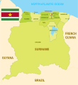
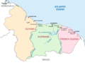 Map of Suriname, Guyana and French Guiana.png 2 381 × 1 829; 301 KB
-
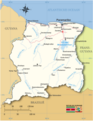
 Map of Suriname.png 8 415 × 5 950; 1,44 MB
-
 Map of Tigri Area Suriname.png 2 523 × 1 785; 3,35 MB
-
 Map Suriname with border rivers (Dutch).png 5 960 × 5 563; 1,18 MB
-
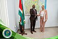 Minister Natural Resources Suriname - UNDP Meeting.jpg 2 048 × 1 365; 596 KB
-
 Ministerie NH Suriname - Kaart van Suriname 01.jpg 1 965 × 1 389; 695 KB
-
 Ministerie NH Suriname - Kaart van Suriname 05.jpg 787 × 592; 88 KB
-
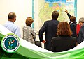
 Ministerie NH Suriname - Kaart van Suriname Presentatie 1.jpg 2 048 × 1 365; 1,05 MB
-
 Ministerie NH Suriname - Kaart van Suriname Presentatie.jpg 2 048 × 1 365; 602 KB
-
 Ministerie NH Suriname - Presentatie met kaart van Suriname.jpg 2 048 × 1 365; 492 KB
-
 Pierre Donders Timbre.png 408 × 610; 565 KB
-
 Proposed Corantijn River Bridge Suriname-Guyana.png 4 210 × 2 975; 462 KB
-
 R. Dobru, strijdliederen uit Suriname (LP).jpg 2 984 × 3 061; 1,57 MB
-
 Seasons in Suriname original.png 7 834 × 6 343; 1,06 MB
-
 Staatsblad van Suriname 1975, No 3.pdf 1 754 × 1 239, 2 paĝoj; 93 KB
-
 Stadsdistrict Paramaribo - Suriname - Location Map.png 7 920 × 6 120; 884 KB
-
 Suriname districts and capitals map.png 5 950 × 8 420; 1,38 MB
-
 Suriname Encyclopedia Map - Places.png 6 563 × 5 950; 2,09 MB
-
 Suriname Encyclopedia Map Physical Features.png 6 563 × 5 950; 2,57 MB
-
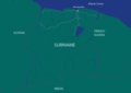
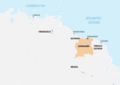 Suriname Location Map South America.png 8 420 × 5 950; 1,02 MB
-
 Suriname Location South America.png 7 920 × 6 120; 1,22 MB
-
 Suriname Locator Map Neutral.svg 842 × 595; 420 KB
-
 Suriname Map Green.png 8 420 × 5 950; 393 KB
-
 Suriname Map.png 5 950 × 7 588; 2,15 MB
-
 Suriname Offshore blocks 2022-2023.png 4 210 × 2 975; 476 KB
-
 Suriname Political Map Corrected.png 6 120 × 7 920; 2,25 MB
-
 The Reciprocal Enforcement of Foreign Judgments (Suriname) Order 1981 (UKSI 1981-735 qp).pdf 1 239 × 1 754, 6 paĝoj; 1,18 MB
-
 The Reciprocal Enforcement of Foreign Judgments (Suriname) Order 1981 (UKSI 1981-735).pdf 1 239 × 1 752, 6 paĝoj; 168 KB
-
 Waterwoods Cyanide site Brokopondo Suriname.png 3 507 × 2 480; 752 KB
-
 Wetboek van strafrecht Suriname.pdf 1 239 × 1 754, 117 paĝoj; 704 KB


.png)


.png)


.png)


.jpg)


