Category:Surveying
跳转到导航
跳转到搜索
field of activity involving locating terrestrial points and the distances and angles between them  | |||||
| 上传媒体 | |||||
| 隶属于 | |||||
|---|---|---|---|---|---|
| 上级分类 | |||||
| 所属实体 | |||||
| |||||
English: Surveying is the art and science of accurately determining the position of points and the distances between them. — For statistical methods for collecting quantitative information, see Category:Survey methodology.
Français : Levé de terrain, géodésie, nivellement, travail du géomètre
子分类
本分类有以下35个子分类,共有35个子分类。
*
A
B
C
D
E
F
- Field Papers (8 F)
H
J
- Jefferson Pier (8 F)
L
M
P
- Plumbing (surveying) (12 F)
R
- Radio latino (6 F)
S
T
分类“Surveying”中的媒体文件
以下200个文件属于本分类,共301个文件。
(上一页)(下一页)-
 1847 Plan of Great Arc between Seronj and Dehra Dun by Everest.jpg 3,422 × 19,346;2.81 MB
-
 1876 Verplanck Colvin Adirondack Survey Book 2, Vol. 270, Series B1406.pdf 1,275 × 1,650,50页;3.38 MB
-
 1878 SNY ADK Survey Field Bk No. 1, F. Tweedy on T&C Line, Vol 158.pdf 1,275 × 1,650,128页;5.15 MB
-
 1879 6 21 Frank Tweedy Field Book, Vol 247, Transcribed by N. Sherry.pdf 1,275 × 1,650,37页;2.18 MB
-
 1879 SW Div ADK Survey, Totten & Crossf, F. Tweedy, Vol 159.pdf 1,275 × 1,650,128页;4.93 MB
-
 1930 AGRICULTURA P18.jpg 1,136 × 1,564;783 KB
-
 1989 canal Siret-Baragan RO WP.jpg 1,337 × 955;159 KB
-
 20140831 Wilkie Sugarloaf Triangulation station 01.jpg 3,888 × 2,592;4.46 MB
-
 20140831 Wilkie Sugarloaf Triangulation station 02.jpg 3,888 × 2,592;4.35 MB
-
 20140831 Wilkie Sugarloaf Triangulation station 03.jpg 3,888 × 2,592;4.9 MB
-
 20140831 Wilkie Sugarloaf Triangulation station 04.jpg 2,592 × 3,888;5.3 MB
-
 49th parallel US Canada border.svg 650 × 350;48 KB
-
 99-Surveying For The Panama Railroad in 1850.jpg 1,389 × 1,096;1.24 MB
-

-
 A student using a Theodolite in field.jpg 2,988 × 5,312;2.01 MB
-
 Acaster South Ings 9 December 2019 (19).JPG 3,000 × 4,000;5.49 MB
-
 Aeqometer small.jpg 166 × 165;11 KB
-
 Aeqometer.jpg 735 × 605;93 KB
-
 Affective Slider Scale.png 1,800 × 707;41 KB
-
 Alignement-2mm,15.353.jpg 341 × 682;99 KB
-
 Alignement½Links,15.356.jpg 342 × 683;92 KB
-
 Alignement½rechts,15.352.jpg 343 × 683;95 KB
-
 Alluvione-serchio-2.jpg 400 × 255;89 KB
-
 Altimetro tascabile, WL, 1955 - 1963 - Caserta, Museo Michelangelo.jpg 1,280 × 960;473 KB
-
 Altötting-Stiftspfarrkirche-Lochmarke.jpg 2,048 × 1,366;1.18 MB
-
 AquaMap Shiphull Position Plot.jpg 758 × 445;109 KB
-
 Archipendolo medievale Museo Michelangelo Caserta.jpg 2,048 × 1,536;1.38 MB
-
 Arlington, WA - Metron.jpg 3,264 × 2,448;2.11 MB
-
 Awa Vermessung.jpg 1,000 × 1,499;1.97 MB
-
 U.S. Coast Survey Encampment (NYPL b11708086-G91F027 009F).tiff 3,072 × 1,653;14.53 MB
-
 Baculo medievale Museo Michelangelo Caserta.jpg 763 × 1,833;182 KB
-
 Beacons.JPG 4,320 × 3,240;5.14 MB
-
 Benson Syndicate Fraudulent Surveys 'THE LIST'.jpg 679 × 1,080;53 KB
-
 BENSON SYNDICATE, NY Times Sept 8 1907.pdf 5,618 × 6,864;833 KB
-
 Binger Hermann policy Field-Notes-Mineral Survey.jpg 1,594 × 1,196;286 KB
-
 Binger-Hermann Genaral-Land-Office.jpg 1,856 × 1,392;1.78 MB
-
 Binger-Hermann-3125-mineral-survey-patented.jpg 1,030 × 1,420;1.07 MB
-

-
 Blue Grass Chemical Agent-Destruction Pilot Plant Surveyor (15587247033).jpg 5,184 × 3,456;6.81 MB
-
 Blue Grass Chemical Agent-Destruction Pilot Plant Surveyor (4923967667).jpg 2,112 × 2,816;1.59 MB
-

-
 Borne oge.jpg 772 × 1,217;199 KB
-
-
 Bruck.jpg 4,963 × 3,508;535 KB
-
 Cadastral survey monumentation manual - draft (IA cadastralsurveym30case).pdf 629 × 827,198页;35.83 MB
-
 Campione del metro, Giuseppe Spano e figlio, Napoli, 1869.jpg 4,083 × 464;182 KB
-
 Canada US border.JPG 2,560 × 1,920;1.87 MB
-
 Cannon in Roy Grove Hampton.jpg 3,648 × 2,736;4.7 MB
-
 Catena agrimensoria, anonima, 1900 - 1949.jpg 4,019 × 381;390 KB
-
 Cgs00989 - Flickr - NOAA Photo Library.jpg 1,944 × 2,592;3.66 MB
-
 Charta Politika.png 178 × 160;27 KB
-
 Christian Arthur Edgar "Tim" O'Brien CBE and Barbara Joy O'Brien.jpg 711 × 1,051;1.18 MB
-

-

-
 Congress Lands in Ohio.png 696 × 824;734 KB
-

-
 Construction site near Yass site cleared and bull dozed.JPG 4,608 × 3,456;4.3 MB
-
 Control point surveying.jpg 1,080 × 718;214 KB
-
 DD Hbf 23 17 23 571000.jpeg 3,024 × 4,032;4.27 MB
-
 Degree of curvature.png 4,265 × 3,069;322 KB
-
 Delaware-wedge.svg 400 × 400;2 KB
-
 Deutsche Grundkarte 5000.JPG 1,779 × 1,417;503 KB
-
 Diamond Points - Surveying Land.png 1,828 × 1,380;3.59 MB
-

-

-
 Divvert.png 545 × 577;15 KB
-
 Dolní Chabry, Pod zámečkem, směr Bílenecké náměstí.jpg 3,264 × 2,448;2 MB
-
 Dominion-land-survey-township.png 400 × 540;28 KB
-
 Dominion-land-system-overview.png 400 × 250;20 KB
-
 Dorsey with fathometer.jpg 817 × 1,024;131 KB
-

-
 During the time of drought.jpg 3,264 × 2,448;3.77 MB
-
 Eastern Boundary Stone (3359936409).jpg 639 × 479;103 KB
-
 Echo operating.jpg 768 × 996;294 KB
-
 Echo Sounding USN.jpg 2,250 × 1,575;329 KB
-
 Echo Sounding USN.PNG 1,073 × 751;1.07 MB
-
 Echolot.png 424 × 451;60 KB
-
 Echolot2.jpg 424 × 451;16 KB
-
 Einzelseite-messkette.jpg 1,447 × 1,098;610 KB
-
 Elevation By Ambit Surveys.jpg 1,588 × 1,123;119 KB
-

-
 Equipe de travail Terrain-Colombie-agric.vignette.jpg 1,831 × 1,240;753 KB
-
 ESURV LOGO - MIDNIGHT BLUE - TRANSPARENT BACKGROUND.png 2,646 × 947;123 KB
-
 ExhibitionSurveyor.jpg 2,304 × 1,728;1.65 MB
-
 Fathometer Survey Bridge Inspection.jpg 4,032 × 3,024;3.51 MB
-
 Fathometer.jpg 1,488 × 1,636;395 KB
-
 Fikspunktsblok.jpg 1,600 × 1,200;407 KB
-
 First Salt Lake City Plat Map, Great Salt Lake City Plot A, 1857.jpg 1,936 × 3,219;786 KB
-
 Fishfinder display showing the mark at Flash Pinnacle P7280213.jpg 3,200 × 2,400;1.85 MB
-
 Flurschaden an der Havel.jpg 3,408 × 2,272;4.49 MB
-
 Budapest I., Tabán, Földmérés teodolittal. Fortepan 99260.jpg 4,526 × 3,648;12.98 MB
-

-
 Fotothek df n-13 0000368.jpg 798 × 820;186 KB
-
 Fotothek df n-13 0000369.jpg 798 × 820;193 KB
-
 Fredningsplade.jpg 1,200 × 1,600;386 KB
-
 Geodetic surveying (IA geodeticsurveyin00caryrich).pdf 718 × 1,170,302页;16.71 MB
-
 Geological Survey Of Victoria.jpg 7,270 × 5,503;40.82 MB
-
 George-U.-Young-MS1130-Plat 310991 1.pdf 3,531 × 2,535;5.21 MB
-
 Geschlossenes Ringpolygon.jpg 200 × 174;7 KB
-
 Goldenes Lot.jpg 2,519 × 4,192;2.69 MB
-
-
 Groma romana, Museo Michelangelo Caserta.jpg 945 × 1,989;297 KB
-
 Gustaf af Klint Vaxholm 2016.jpeg 6,000 × 4,000;11.72 MB
-
 GéodésieCorseContinent.jpg 1,573 × 1,257;1.32 MB
-
 HasslerCollection 001.jpg 3,462 × 4,677;3.02 MB
-
 Helmert (seven-parameter) transformation.svg 530 × 457;54 KB
-
 Highland-Pines-Mineral-Survey-2424-Sheet-2.pdf 3,593 × 2,479;5.19 MB
-
 Highland-Pines-Plat-G-amended.jpg 1,753 × 1,240;2.2 MB
-
 HMS Torch, Sydney. 1855, Conrad Martens.jpg 3,028 × 2,024;3.13 MB
-
 I35W Collapse - FBI Evidence Team (4).jpg 3,008 × 2,000;1.52 MB
-
 IMG 20180716 160257 HDR.jpg 4,608 × 3,456;7.05 MB
-
 Intav.jpg 247 × 232;18 KB
-
 Iran Ethnic 2016 Social Survey - Kevan Harris.jpg 1,500 × 859;96 KB
-
 Istituto geografico militare, biblioteca.jpg 301 × 300;97 KB
-
 Johann-Jodocus-Beck-Tractatus-de-jure-limitum MG 0976.tif 3,493 × 4,280;42.81 MB
-
 Kayrasuo.jpg 900 × 635;144 KB
-
 Kotaufgabe01-w.png 2,028 × 1,546;289 KB
-
 Kuhberg (Stützengrün) Darstellung um 1915.jpg 1,893 × 1,749;2.56 MB
-
 La Rochefoucauld Enseigne géomètre 2012.jpg 4,097 × 2,840;6.46 MB
-
 Landmeter in de haven van Paramaribo, Bestanddeelnr 252-2170.jpg 2,625 × 2,587;821 KB
-
 Leica Flexline TS09 setup at top of Timin Pass,Magarima.jpg 2,256 × 1,504;1.23 MB
-
 Level of water.jpg 2,448 × 3,264;2.05 MB
-
 Leveling Rod reading examples jpeg.png 2,279 × 3,326;456 KB
-
 Leveling Rod reading examples.jpg 2,279 × 3,326;316 KB
-
 Levelling Device.jpg 1,504 × 2,256;3.23 MB
-
 Life of Frank Tweedy.pdf 1,275 × 1,650,71页;782 KB
-
 Linienzug.jpg 200 × 214;4 KB
-
 Livellette.png 512 × 384;5 KB
-
 Livello Chezy, Salmoiraghi, Milano - 1900 - 1924 - Caserta, Museo Michelangelo.jpg 3,697 × 3,044;680 KB
-
 Livello Lenoir, anonimo, 1875 - 1899 - Caserta, Museo Michelangelo.jpg 1,280 × 960;455 KB
-
 Logo HGV.jpg 868 × 868;51 KB
-
 LondonAvCanalBreechFloodwallSurveyer.jpg 2,592 × 1,944;1.98 MB
-
 Low Mill, Addingham - geograph.org.uk - 425427.jpg 640 × 456;135 KB
-
 LV Logo.jpg 228 × 119;26 KB
-
 LV95-2600000-1200000.jpg 708 × 530;154 KB
-
 Manicouagan River Survey.jpg 942 × 691;107 KB
-
 Map bele ffig 4.jpg 1,080 × 1,440;193 KB
-
 Map of South Australia-Victoria border anomaly.tif 1,665 × 1,571;9.98 MB
-
 Mapa numeryczna - przyklad.jpg 944 × 514;291 KB
-
 Marksteinzeuge Häslach Walddorfhäslach Slg. OW.jpg 1,785 × 2,544;2.07 MB
-
 Marksteinzeuge Pliezhausen Slg. OW.jpg 2,660 × 1,781;2.23 MB
-
 Marksteinzeuge Rübgarten Pliezhausen Slg. OW.jpg 2,474 × 2,547;3.29 MB
-
 Marksteinzeuge Stuttgart Slg. OW.jpg 4,020 × 2,272;5.04 MB
-
 Marksteinzeuge Walddorf Walddorfhäslach Slg. OW.jpg 2,611 × 2,624;3.31 MB
-
 Marquois Scales.jpg 3,000 × 4,001;2.08 MB
-
 Measurement artillery data.jpg 4,965 × 3,200;6.45 MB
-

-
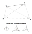 MetodiHansen.png 1,070 × 1,121;31 KB
-
 MIneral-Survey-1130-Cancelled.jpg 644 × 652;196 KB
-
 Mineral-Survey-12577-amended-Binger Hermann.jpg 1,846 × 1,386;1.24 MB
-
 Mining-Reporter-1904-What-The-Government.pdf 1,275 × 1,650;363 KB
-

-
 Naters Observatorium Simplontunnel 1900.jpg 1,604 × 1,020;1.16 MB
-
 National Grid for Great Britain with central meridian.gif 235 × 434;8 KB
-
 Nebraska-SE-counties-PLSS.png 600 × 288;42 KB
-
 Neptune-survey-ship.jpg 800 × 535;61 KB
-
 Nivellementsbolt.jpg 1,600 × 1,200;298 KB
-
 Nivellementsmarkstein.jpg 1,936 × 2,592;2.42 MB
-
 Nivelleringspunkt ved den gamle grænse.jpg 3,840 × 5,760;13.86 MB
-
 Nivellieren stilisiert.svg 571 × 600;8 KB
-
 NNSA-NSO-1443.jpg 1,920 × 2,560;2.89 MB
-
 NRCSMI01022 - Michigan (4633)(NRCS Photo Gallery).jpg 1,500 × 2,100;6.82 MB
-
 NRCSMI01023 - Michigan (4635)(NRCS Photo Gallery).jpg 2,100 × 1,500;6.86 MB
-
 NRCSMI01026 - Michigan (4641)(NRCS Photo Gallery).jpg 1,500 × 2,100;5.89 MB
-
 Nueva Esperanza, Ver., Mexico - panoramio.jpg 4,000 × 3,000;4.26 MB
-
 Observation du réseau géodésique de base.jpg 400 × 300;46 KB
-
 Offenes Polygon.jpg 200 × 169;6 KB
-
 Old Tower Cringles Silsden - geograph.org.uk - 603167.jpg 640 × 425;57 KB
-
 Olof Emanuel Näslund (1).gif 400 × 565;198 KB
-
 Optical Wedge.jpg 500 × 568;205 KB
-
 Ordnance Survey Surveyor - geograph.org.uk - 92314.jpg 426 × 640;72 KB
-
 Orthogonalverfahren.jpg 200 × 187;10 KB
-
 OSU 40th Parallel Closeup.JPG 3,648 × 2,736;4.9 MB
-
 OSU 40th Parallel Marker.JPG 3,648 × 2,736;4.31 MB
-
 PA-Delaware-wedge.png 659 × 1,002;470 KB
-
 Patent Nr. 10 2021 003 779.jpg 2,477 × 3,500;409 KB
-
 Person practice using a sight level for mapping ground.jpg 2,920 × 1,947;735 KB
-
 Pfizer Survey.png 593 × 292;12 KB
-

-
 Plan of Valley of Bendigo in 1858 by R.W. Larritt.jpg 7,000 × 3,206;3.83 MB
-

-
 Plat Map of the proposed Bingham Canyon twon as part of the incorporation records, 1904.tif 3,469 × 3,746;18.69 MB
-
 Podcast with Dr. Alvita Puspa Handayani.jpg 1,280 × 921;143 KB
-
 Polare Aufnahme eines Ringpolygons.jpg 859 × 846;27 KB
-
 Pothenot.png 512 × 384;9 KB
-
 Practijckdeslantmetens.jpg 600 × 480;65 KB
-
 Precise Level Benchmark, Singapore.jpg 3,024 × 4,032;5.43 MB
-
 Principle of SBES.svg 549 × 485;17 KB
-
 Prismjadanza.png 518 × 534;11 KB
-
 PROBLIQUE.png 512 × 384;7 KB
-
 Quadrante medievale Museo Michelangelo Caserta.jpg 2,048 × 1,536;1.37 MB
-
 Questionnaire survey with farmers of Koshi Tappu Wildlife Reserve.jpg 4,160 × 2,340;3.88 MB
-
 Raaistelsel langs de kust.jpg 1,197 × 678;108 KB
-
 Ragguagliate.png 512 × 384;11 KB
-
 Ramsden's zenith telescope.png 443 × 720;180 KB
-
 Reading Leveling Rod jpeg.png 2,268 × 3,326;319 KB
-
 Reading Leveling Rod.jpg 2,268 × 3,326;330 KB
-
 Reflector receiving and transmitting laser.jpg 1,440 × 2,560;570 KB
-
 Remote Sensing Illustration-ar.png 1,302 × 1,217;471 KB
-
 Remote Sensing Illustration.jpg 1,302 × 1,217;148 KB


_(20375100191).jpg)

.JPG)


.jpg)
.jpg)
.jpg)


.jpg)


.jpg)


.jpg)


_Darstellung_um_1915.jpg)


.jpg)


(NRCS_Photo_Gallery).jpg)
(NRCS_Photo_Gallery).jpg)
(NRCS_Photo_Gallery).jpg)


.gif)


_BLDG._W._Spgs._SEWER_SURVEY_AUG_60_00449_(51207905270).jpg)


_-_NARA_-_26428686.jpg)
_transformation.svg)