Category:Thuringian Forest
Salti al navigilo
Salti al serĉilo
mountain range in the German state of Thuringia   | |||||
| Alŝuti plurmedion | |||||
| Estas |
| ||||
|---|---|---|---|---|---|
| Nomita laŭ | |||||
| Lokiĝas en protektata areo | |||||
| Loko | Turingio, Germanio | ||||
| Larĝeco |
| ||||
| Longo |
| ||||
| Montaro |
| ||||
| Plej alta punkto | |||||
| Areo |
| ||||
| Supermara alteco |
| ||||
 | |||||
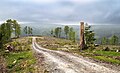
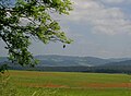
English: The Thuringian Forest is a mountain range in the state of Thuringia in Germany.
Deutsch: Der Thüringer Wald ist ein Mittelgebirge im Freistaat Thüringen (Deutschland).
Subkategorioj
Ĉi tiu kategorio havas la 18 jenajn subkategoriojn, el 18 entute.
A
- Ausgebrannter Stein (5 D)
F
G
- Geology of Thuringian Forest (2 D)
H
L
M
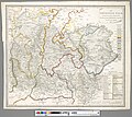
- Maps of Thuringian Forest (17 D)
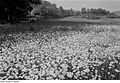
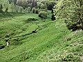
- Meadows in Thuringian Forest (12 D)
N
R
- Rennsteigteich (1 D)
T
V
W
- Wächtersteich (5 D)
Dosieroj en kategorio “Thuringian Forest”
La jenaj 70 dosieroj estas en ĉi tiu kategorio, el 70 entute.
-
 Andesitic rock of Rotliegend series.jpg 1 145 × 1 123; 790 KB
-
 Apfelstädt an der Hammerwand 3.jpg 3 264 × 2 448; 1,77 MB
-
-
 Bundesarchiv Bild 183-1990-0822-302, Katzhütte, Mülldeponie.jpg 781 × 533; 99 KB
-
 Clausbergpass.jpg 2 304 × 1 728; 2,69 MB
-
 Cursdel aus dem Thüringer Wald.jpg 3 159 × 3 784; 9,7 MB
-
 Deforested area, Goldisthal, 2023-05-20.jpg 5 619 × 3 411; 14,71 MB
-
 Der Thüringer Wald.jpg 5 922 × 5 295; 12,5 MB
-
 Die Gartenlaube (1856) b 308.jpg 6 183 × 1 872; 4,04 MB
-
 Die Gartenlaube (1859) b 688.jpg 1 603 × 1 561; 448 KB
-
 Die Gartenlaube (1860) b 028.jpg 1 085 × 976; 434 KB
-
 ESA Naturparkroute ThrWald.jpg 952 × 1 428; 972 KB
-
 Fairy Forest.JPG 4 678 × 3 118; 9,79 MB
-
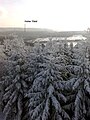
 Fog over Eisenach.jpg 4 249 × 2 620; 5,23 MB
-
 Fotothek df ps 0000728 Pflanzen ^ Sonstiges.jpg 800 × 552; 263 KB
-

-
 Fotothek df roe-neg 0006701 019 Bewohntes Tal und Berghänge.jpg 529 × 820; 222 KB
-
 Fotothek df roe-neg 0006701 020 Bewohntes Tal und Berghänge.jpg 529 × 820; 171 KB
-
 Fotothek df roe-neg 0006701 021 Bewohntes Tal und Berghänge.jpg 800 × 549; 143 KB
-
 Fsg wickersdorf 1911 panorama.jpg 1 333 × 465; 200 KB
-
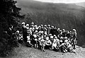
 Fsg wickersdorf gruppenzeltlager 1911.jpg 1 553 × 1 112; 409 KB
-
 Fsg wickersdorf wanderung 1931.jpg 1 355 × 930; 297 KB
-
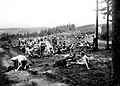
 Fsg wickersdorf zeltlager 1911.jpg 1 682 × 1 164; 602 KB
-
 Goldisthal-Königstannenstumpf.jpg 5 616 × 3 744; 2,53 MB
-
 Goldisthal-Wurzelberghütte.jpg 5 616 × 3 744; 4,29 MB
-
 Gr hermannsberg ausblick.jpg 8 060 × 2 316; 5,3 MB
-
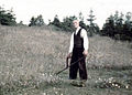 Grasmahd mit Sense.jpg 1 230 × 877; 527 KB
-
 Aussicht vom Grossen Beerberg ins Tal.jpg 1 600 × 1 200; 922 KB
-
 Hoher Stein vantage point near Oberhof, Germany, Oct 2021.jpg 4 000 × 2 250; 3,96 MB
-
 Hoher Wald.jpg 697 × 930; 166 KB
-
 Ilmbeginn.jpg 800 × 600; 409 KB
-
 Ilmenau Ratssteinbruch.JPG 3 888 × 2 592; 2,11 MB
-
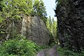
 J29 909 »Wolfsschlucht«.jpg 5 760 × 3 840; 7,6 MB
-
 J29 911 »Wolfsschlucht«, Wegdruchbruch.jpg 3 748 × 5 622; 6,18 MB
-
 J29 912 »Wolfsschlucht«, Wegdruchbruch.jpg 3 734 × 5 601; 6,29 MB
-
 J29 913 »Wolfsschlucht«, Wegdruchbruch.jpg 5 937 × 3 958; 10,41 MB
-
 J29 914 »Wolfsschlucht« (unten).jpg 5 934 × 3 956; 9,47 MB
-
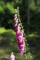 J29 915 Roter Fingerhut.jpg 3 792 × 5 688; 3,33 MB
-
 Katzhütte-Jagdhaus-Lindig.jpg 3 744 × 4 992; 2,22 MB
-
 KilianStein Felsnadel bei Winterstein.JPG 1 536 × 2 048; 653 KB
-
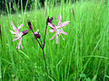 Kuckucks-Lichtnelke Lychnis flos-cuculi.JPG 3 648 × 2 736; 2,1 MB
-
 Landschaft Thueringen 01.jpg 1 520 × 2 688; 1,37 MB
-
 Landschaft Thueringen 02.jpg 1 520 × 2 688; 1,2 MB
-
 Lower Permian fanglomerate.jpg 1 829 × 1 223; 1,46 MB
-
 Lower Permian fern leaves.jpg 1 376 × 1 011; 647 KB
-
 Metilstein Hill in Eisenach.jpg 5 237 × 2 637; 6,19 MB
-
 Mushroom mansion.jpg 5 456 × 3 632; 4,59 MB
-
 Neuhaus-Franzosengrab.jpg 5 616 × 3 744; 2,56 MB
-
 Plänkners Aussicht am großen Beerberg - panoramio.jpg 1 600 × 1 200; 623 KB
-
 RebogThWa.jpg 1 469 × 983; 426 KB
-
 Rennsteiggarten Pfanntalskopf 2.jpg 4 320 × 3 240; 3,46 MB
-
 Rennsteiglauf-Denkmal.jpg 1 487 × 2 306; 616 KB
-
 Ringberg (Ruhla).jpg 4 000 × 3 000; 3,9 MB
-
 RUHLA WEGWEISER.jpg 881 × 1 175; 1 016 KB
-
 Ruppertsbach-Am-Hosenlatz-1.jpg 2 592 × 1 944; 1,39 MB
-
 Ruppertsbach-Am-Hosenlatz-2.jpg 2 592 × 1 944; 1,4 MB
-
 Staudenkopf (2006-07-01).jpg 1 795 × 975; 109 KB
-
 Staudenkopf.jpg 800 × 586; 36 KB
-
 Steinach bei Heubisch 1.jpg 1 600 × 1 063; 437 KB
-
 Talsperre schmalwasser jungbaeume d schmidt 08 2006.jpg 1 200 × 1 600; 404 KB
-
 Tambach Marderbachtal 3.jpg 2 448 × 3 264; 1 024 KB
-
 The Rhine and northern Germany- handbook for travellers (1870) (14765786142).jpg 2 032 × 1 460; 1,35 MB
-
 Thuringian forest near saalfeld.jpg 2 000 × 1 333; 1 MB
-
 Thüringer Wald in der Nähe von Oberhof. - geograph.org.uk - 8055.jpg 640 × 480; 91 KB
-
 Thüringer Wald.JPG 443 × 590; 78 KB
-
 Versuche.jpg 1 536 × 2 048; 882 KB
-
 WAK W UNKER 0040.jpg 1 314 × 985; 1,07 MB
-
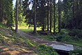
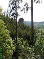
 Waldlandschaft im Thüringer Wald.jpg 4 032 × 2 268; 6,12 MB
-
 Werraquelle.jpg 1 275 × 1 962; 263 KB
-
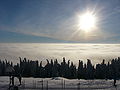
 Winter auf dem Melpertser Rasenberg.jpg 9 519 × 5 000; 10,87 MB


_b_688.jpg)
_b_028.jpg)


.jpg)


.jpg)


.jpg)


_(14765786142).jpg)


_b_308.jpg)