Category:Vists kyrka, Östergötland
Jump to navigation
Jump to search
| Object location | | View all coordinates using: OpenStreetMap |
|---|
|
This is a category about an ecclesiastical monument in Sweden, number 21300000011715 (sub-number: 21400000025334) in the RAÄ buildings database.
|
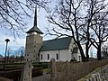
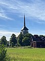
church building in Linköping Municipality, Sweden  | |||||
| Upload media | |||||
| Instance of | |||||
|---|---|---|---|---|---|
| Location | Sturefors, Linköping Municipality, Östergötland County, Sweden | ||||
| Occupant |
| ||||
| Inception |
| ||||
| Replaces | |||||
 | |||||
Subcategories
This category has only the following subcategory.
Media in category "Vists kyrka, Östergötland"
The following 11 files are in this category, out of 11 total.
-
 Vist kyrka 2021.jpg 4,032 × 3,024; 6.78 MB
-
 Vist kyrka Sturefors.jpg 4,404 × 3,126; 9.68 MB
-
 Vist kyrkas altare 2020.jpg 4,928 × 3,264; 3.98 MB
-
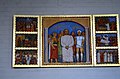 Vist kyrkas altarskåp 2020.jpg 4,928 × 3,264; 3.84 MB
-
 Vist kyrkas dopfunt 2020.jpg 4,928 × 3,264; 4.12 MB
-
 Vist kyrkas krucifix 2020.jpg 3,264 × 4,928; 3.82 MB
-
 Vist kyrkas orgelläktare 2020.jpg 4,928 × 3,264; 3.93 MB
-
 Vist kyrkas predikstol 2020.jpg 3,264 × 4,928; 4.02 MB
-
 Vists kyrka Östergötland Sverige 1961.jpg 400 × 400; 38 KB
-
 Vists kyrka, Sturefors, från väster.jpg 3,024 × 4,032; 972 KB
-
 Vists kyrka.jpg 2,172 × 3,051; 2.15 MB


Categories:
- Buildings in Sturefors
- Built in Linköping Municipality in 1965
- Churches in the Diocese of Linköping
- Churches in Linköping Municipality
- Churches in Östergötland
- Stone churches in Östergötland County
- White churches in Sweden
- Vist District
- Medieval churches in Östergötland County
- Destroyed in Sweden in 1961
- Churches in Östergötland County built in 1965
- Rolf Bergh