Category:Westrup, Dwingeloo
Jump to navigation
Jump to search
| Object location | | View all coordinates using: OpenStreetMap |
|---|
 | |||||
| Upload media | |||||
| Instance of | |||||
|---|---|---|---|---|---|
| Location | Dwingeloo, Drenthe, Netherlands | ||||
| Street address |
| ||||
| Located on street |
| ||||
| Heritage designation |
| ||||
 | |||||
|
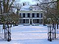
This is a category about rijksmonument number 14231
|
| Address |
|
Media in category "Westrup, Dwingeloo"
The following 5 files are in this category, out of 5 total.
-
 Overzicht - Dwingeloo - 20065686 - RCE.jpg 1,200 × 812; 300 KB
-
 Overzicht - Dwingeloo - 20065687 - RCE.jpg 1,200 × 809; 299 KB
-
 Westrup Dwingeloo.jpg 1,296 × 972; 239 KB
-
 Westrup in Dwingeloo.JPG 4,032 × 3,024; 2.49 MB
-
 Westrup1.JPG 1,840 × 1,232; 1.02 MB


