Category:Wirral Grammar School for Boys
Jump to navigation
Jump to search
| Object location | | View all coordinates using: OpenStreetMap |
|---|
school in Wirral, UK  | |||||
| Upload media | |||||
| Instance of |
| ||||
|---|---|---|---|---|---|
| Location | |||||
| Street address |
| ||||
| Inception |
| ||||
| official website | |||||
 | |||||
Media in category "Wirral Grammar School for Boys"
The following 9 files are in this category, out of 9 total.
-
 Harold Wilson plaque, Wirral Grammar School for Boys.jpg 3,650 × 2,698; 12.09 MB
-
 View of Wirral Grammar School for boys-1.jpg 720 × 481; 115 KB
-
 Wirral Grammar Boys Crest.jpg 200 × 220; 15 KB
-
 Wirral Grammar School for Boys (1).jpg 4,320 × 3,240; 3.45 MB
-
 Wirral Grammar School for Boys (2).jpg 4,320 × 3,240; 3.56 MB
-
 Wirral Grammar School for Boys (3).jpg 4,320 × 3,240; 2.62 MB
-
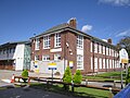
 Wirral Grammar School for Boys, Bebington, UK - 20090504.jpg 720 × 481; 78 KB
-
 Wirral Grammar School View from Students Entrance in Spring.jpg 720 × 481; 78 KB
-
 WirralGrammarBoysCrest.png 607 × 671; 323 KB


.jpg)
.jpg)
.jpg)

