Category:Woodton
Jump to navigation
Jump to search
English: Woodton is a village and civil parish in the English county of Norfolk. It is situated some 7 km north-west of the Suffolk town of Bungay, and 20 km south-east of Norfolk's capital city of Norwich.
village in Norfolk, UK  | |||||
| Upload media | |||||
| Instance of | |||||
|---|---|---|---|---|---|
| Location | South Norfolk, Norfolk, East of England, England | ||||
| Area |
| ||||
 | |||||
Media in category "Woodton"
The following 200 files are in this category, out of 253 total.
(previous page) (next page)-
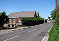
 (Muddy) Green Lane, Woodton - geograph.org.uk - 4347841.jpg 640 × 480; 214 KB
-
 1667 - geograph.org.uk - 1431249.jpg 640 × 480; 97 KB
-
 A foggy December day on Nobbs' Lane - geograph.org.uk - 5217617.jpg 640 × 360; 360 KB
-

-
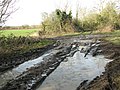
 A muddy Wash Lane - geograph.org.uk - 4802429.jpg 640 × 480; 545 KB
-

-

-

-
 All Saints Church sign - geograph.org.uk - 3758850.jpg 2,304 × 3,072; 1.86 MB
-
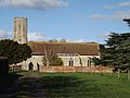
 All Saints Church, Woodton - geograph.org.uk - 3758840.jpg 3,072 × 2,304; 1.77 MB
-
 All Saints Church, Woodton - geograph.org.uk - 3758851.jpg 3,072 × 2,304; 1.76 MB
-
 All Saints, Woodton - geograph.org.uk - 5061613.jpg 640 × 480; 45 KB
-
 All Saints, Woodton, altar - geograph.org.uk - 5068988.jpg 640 × 480; 68 KB
-
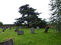
 All Saints, Woodton, churchyard (a) - geograph.org.uk - 5068973.jpg 640 × 480; 55 KB
-
 All Saints, Woodton, churchyard (b) - geograph.org.uk - 5068975.jpg 640 × 480; 126 KB
-
 All Saints, Woodton, churchyard (c) - geograph.org.uk - 5068976.jpg 640 × 480; 53 KB
-
 All Saints, Woodton, churchyard (d) - geograph.org.uk - 5068977.jpg 640 × 480; 40 KB
-
 All Saints, Woodton, churchyard (e) - geograph.org.uk - 5068978.jpg 640 × 480; 52 KB
-
 All Saints, Woodton, churchyard (f) - geograph.org.uk - 5068980.jpg 640 × 480; 79 KB
-
 All Saints, Woodton, font - geograph.org.uk - 5068983.jpg 480 × 640; 41 KB
-
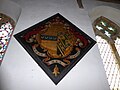 All Saints, Woodton, hatchment (A) - geograph.org.uk - 5069001.jpg 640 × 480; 64 KB
-
 All Saints, Woodton, hatchment (B) - geograph.org.uk - 5069003.jpg 640 × 480; 34 KB
-
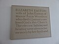 All Saints, Woodton, memorial (A) - geograph.org.uk - 5069005.jpg 640 × 480; 37 KB
-
 All Saints, Woodton, memorial (B) - geograph.org.uk - 5069006.jpg 480 × 640; 36 KB
-
 All Saints, Woodton, memorial (C) - geograph.org.uk - 5069007.jpg 480 × 640; 37 KB
-
 All Saints, Woodton, memorial (D) - geograph.org.uk - 5069008.jpg 480 × 640; 45 KB
-
 All Saints, Woodton, memorial (E) - geograph.org.uk - 5069009.jpg 640 × 480; 58 KB
-
 All Saints, Woodton, memorial (F) - geograph.org.uk - 5069010.jpg 640 × 480; 39 KB
-
 All Saints, Woodton, memorial (G) - geograph.org.uk - 5069013.jpg 640 × 480; 25 KB
-
 All Saints, Woodton, memorial (H) - geograph.org.uk - 5069014.jpg 640 × 480; 28 KB
-
 All Saints, Woodton, memorial (I) - geograph.org.uk - 5069015.jpg 640 × 480; 64 KB
-
 All Saints, Woodton, memorial (K) - geograph.org.uk - 5069020.jpg 480 × 640; 41 KB
-
 All Saints, Woodton, memorial (M) - geograph.org.uk - 5069026.jpg 480 × 640; 76 KB
-
 All Saints, Woodton, memorial (N) - geograph.org.uk - 5069027.jpg 480 × 640; 46 KB
-
 All Saints, Woodton, memorial (O) - geograph.org.uk - 5069029.jpg 640 × 480; 80 KB
-
 All Saints, Woodton, memorial (P) - geograph.org.uk - 5069030.jpg 640 × 480; 81 KB
-
 All Saints, Woodton, memorial (Q) - geograph.org.uk - 5069031.jpg 640 × 480; 30 KB
-
 All Saints, Woodton, memorial (R) - geograph.org.uk - 5069032.jpg 640 × 480; 67 KB
-
 All Saints, Woodton, memorial (S) - geograph.org.uk - 5069028.jpg 480 × 640; 89 KB
-
 All Saints, Woodton, memorials (J) - geograph.org.uk - 5069018.jpg 640 × 480; 48 KB
-
 All Saints, Woodton, memorials (L) - geograph.org.uk - 5069021.jpg 480 × 640; 51 KB
-
 All Saints, Woodton, noticeboard - geograph.org.uk - 5068981.jpg 480 × 640; 47 KB
-
 All Saints, Woodton, organ - geograph.org.uk - 5068989.jpg 480 × 640; 90 KB
-
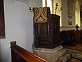 All Saints, Woodton, pulpit - geograph.org.uk - 5068986.jpg 640 × 480; 47 KB
-

-

-

-
 Ancient ash tree beside Wash Lane - geograph.org.uk - 2963798.jpg 480 × 640; 320 KB
-
 Approaching Norwich Road on Wash Lane - geograph.org.uk - 2963810.jpg 516 × 640; 339 KB
-
 Approaching the junction with Pound Lane - geograph.org.uk - 2963796.jpg 640 × 480; 285 KB
-
 B 1332 at Woodton - geograph.org.uk - 1899777.jpg 640 × 480; 52 KB
-
 B1332 Norwich Road entering Woodton - geograph.org.uk - 4204416.jpg 3,072 × 2,304; 1.99 MB
-
 B1332 Norwich Road, Kirstead Green - geograph.org.uk - 4126441.jpg 2,803 × 2,106; 543 KB
-
 B1332 Norwich Road, Woodton - geograph.org.uk - 3414013.jpg 3,072 × 2,304; 1.33 MB
-
 B1332 Norwich Road, Woodton - geograph.org.uk - 3414024.jpg 3,072 × 2,304; 1.37 MB
-
 B1332 Norwich Road, Woodton - geograph.org.uk - 4126453.jpg 3,072 × 2,304; 1.84 MB
-
 B1332 Norwich Road, Woodton - geograph.org.uk - 4127089.jpg 3,072 × 2,304; 826 KB
-
 B1332 Norwich Road, Woodton - geograph.org.uk - 4204389.jpg 3,072 × 2,304; 1.62 MB
-
 B1527 Church Road ^ Norwich Road Postbox - geograph.org.uk - 3413949.jpg 3,072 × 2,304; 1.42 MB
-
 B1527 Church Road, Woodton - geograph.org.uk - 3583892.jpg 3,072 × 2,304; 1.32 MB
-
 B1527 Shot New Road, Woodton - geograph.org.uk - 3583922.jpg 3,072 × 2,304; 1.39 MB
-
 B1527 Shot New Road, Woodton - geograph.org.uk - 3583924.jpg 3,072 × 2,304; 1.35 MB
-
 B1532 Church Road, Woodton - geograph.org.uk - 3414032.jpg 3,072 × 2,304; 1.51 MB
-
 Beckett's Wood - geograph.org.uk - 4347838.jpg 640 × 480; 259 KB
-
 Black Welsh Mountain sheep (ewe) - geograph.org.uk - 4332171.jpg 620 × 640; 279 KB
-
 Black Welsh Mountain sheep - geograph.org.uk - 4332170.jpg 640 × 517; 216 KB
-
 Chapel Hill sign - geograph.org.uk - 3475105.jpg 3,072 × 2,304; 1.62 MB
-
 Chapel Hill, Woodton - geograph.org.uk - 3475083.jpg 3,072 × 2,304; 1.22 MB
-
 Church Road sign - geograph.org.uk - 3413986.jpg 3,072 × 2,304; 1.67 MB
-
 Concrete hard standing beside Wash Lane - geograph.org.uk - 2963758.jpg 640 × 480; 213 KB
-
 Crop field beside Green Lane - geograph.org.uk - 4332211.jpg 640 × 480; 148 KB
-
 Crop field beside Green Lane - geograph.org.uk - 4332225.jpg 640 × 480; 204 KB
-
 Crop field east of Green Lane - geograph.org.uk - 4332291.jpg 640 × 480; 170 KB
-
 Crop fields beside Nobbs' Lane - geograph.org.uk - 5217606.jpg 640 × 360; 274 KB
-
 Crop fields by Oak Farm - geograph.org.uk - 4332180.jpg 640 × 480; 169 KB
-
 Crop fields by Springwood - geograph.org.uk - 4332226.jpg 640 × 480; 216 KB
-
 Derelict shed in Green Lane, Woodton - geograph.org.uk - 4347845.jpg 640 × 480; 206 KB
-
 Ditch beside Wash Lane - geograph.org.uk - 3846674.jpg 480 × 640; 229 KB
-
 Drainage ditch beside Wash Lane - geograph.org.uk - 4802443.jpg 640 × 480; 525 KB
-

-
 Entering Hedenham on the B1332 Norwich Road - geograph.org.uk - 3414057.jpg 3,072 × 2,304; 1.23 MB
-
 Entering Woodton on Hempnall Road - geograph.org.uk - 4127125.jpg 2,914 × 2,189; 1,007 KB
-
 Entering Woodton on the B1332 Norwich Road - geograph.org.uk - 3414054.jpg 2,914 × 2,189; 1.51 MB
-
 Entering Woodton on the B1332 Norwich Road - geograph.org.uk - 4204385.jpg 3,072 × 2,304; 1.92 MB
-
 Entrance to Old Hall - geograph.org.uk - 4204381.jpg 3,072 × 2,304; 1.97 MB
-
 Farm buildings north of Winter's Grove - geograph.org.uk - 5217623.jpg 640 × 360; 279 KB
-
 Farm track crossing Green Lane - geograph.org.uk - 4332281.jpg 640 × 480; 200 KB
-
 Farm track to Springwood - geograph.org.uk - 4332200.jpg 640 × 480; 210 KB
-
 Farm track to Springwood - geograph.org.uk - 4332288.jpg 640 × 480; 179 KB
-
 Fields by Frog's Farm - geograph.org.uk - 4332161.jpg 640 × 480; 181 KB
-
 Fields east of Green Lane - geograph.org.uk - 4332292.jpg 640 × 480; 146 KB
-
 Fields north of Low Road - geograph.org.uk - 3846543.jpg 640 × 480; 130 KB
-
 Fields north of Wash Lane - geograph.org.uk - 2963788.jpg 640 × 480; 189 KB
-
 Fields north of Wash Lane - geograph.org.uk - 4802448.jpg 640 × 480; 388 KB
-
 Fields south of Wash Lane - geograph.org.uk - 4802426.jpg 640 × 546; 499 KB
-
 Fields west of Green Lane - geograph.org.uk - 4332285.jpg 640 × 480; 184 KB
-
 Fields west of New Delight Plantation - geograph.org.uk - 4802412.jpg 640 × 597; 407 KB
-
 Flowering hedgerow beside Wash Lane - geograph.org.uk - 2963791.jpg 640 × 480; 262 KB
-
 Footpath to Shotesham Road - geograph.org.uk - 5217620.jpg 640 × 360; 223 KB
-
 Footpath to Woodton - geograph.org.uk - 3846670.jpg 640 × 480; 216 KB
-
 Frozen field beside Green Lane - geograph.org.uk - 4332241.jpg 640 × 480; 221 KB
-
 Frozen ivy (Hedera spec) berries - geograph.org.uk - 4332236.jpg 640 × 567; 187 KB
-
 Frozen puddle - geograph.org.uk - 4332246.jpg 640 × 539; 342 KB
-
 Frozen puddle in cereal crop field - geograph.org.uk - 4332240.jpg 640 × 480; 186 KB
-
 Frozen puddle in field - geograph.org.uk - 4332243.jpg 640 × 480; 236 KB
-
 Full ditch beside Wash Lane - geograph.org.uk - 3846667.jpg 640 × 480; 199 KB
-

-
 Full drainage ditch beside Wash Lane - geograph.org.uk - 4802433.jpg 640 × 480; 446 KB
-
 Game bird crop - geograph.org.uk - 4332303.jpg 640 × 480; 181 KB
-

-
 Game bird feeder beside farm track - geograph.org.uk - 4802456.jpg 640 × 480; 460 KB
-
 Game bird feeder on farm track - geograph.org.uk - 4802453.jpg 640 × 592; 471 KB
-
 Garlands of Black bryony - geograph.org.uk - 5217619.jpg 640 × 360; 425 KB
-
 Gate into Winter's Grove - geograph.org.uk - 5217610.jpg 640 × 360; 369 KB
-
 Green Lane, Kirstead, a footpath - geograph.org.uk - 4355033.jpg 1,024 × 768; 661 KB
-
 Green Lane, Woodton - geograph.org.uk - 4347846.jpg 640 × 480; 188 KB
-
 Harvey Lane - geograph.org.uk - 3475039.jpg 3,072 × 2,304; 1.27 MB
-
 Harvey Lane - geograph.org.uk - 3475047.jpg 3,072 × 2,304; 1.38 MB
-
 Harvey Lane sign - geograph.org.uk - 3475043.jpg 2,983 × 2,241; 1.69 MB
-
 Harvey Lane sign - geograph.org.uk - 4124810.jpg 2,989 × 2,243; 1.39 MB
-
 Harvey Lane, Kirstead Green - geograph.org.uk - 4124941.jpg 3,072 × 2,304; 1.72 MB
-
 Harvey Lane, Kirstead Green - geograph.org.uk - 4126429.jpg 3,072 × 2,304; 853 KB
-
 Harvey's Lane approaching Norwich Road - geograph.org.uk - 4347877.jpg 640 × 480; 218 KB
-
 Heating oil delivery on Springwood Lane - geograph.org.uk - 4332187.jpg 640 × 480; 234 KB
-
 Hedge field boundary north of Wash Lane - geograph.org.uk - 2963761.jpg 640 × 480; 214 KB
-
 Hempnall and area from the east, aerial 2017 - geograph.org.uk - 5521884.jpg 1,024 × 613; 113 KB
-

-

-
 Hempnall Road Post Office Postbox - geograph.org.uk - 3475125.jpg 2,304 × 3,072; 1.46 MB
-
 Hempnall Road Post Office Postbox - geograph.org.uk - 3475127.jpg 2,304 × 3,072; 1.43 MB
-
 Hempnall Road Post Office Postbox - geograph.org.uk - 3475129.jpg 2,304 × 3,072; 1.39 MB
-
 Hempnall Road sign - geograph.org.uk - 3475103.jpg 3,072 × 2,304; 1.67 MB
-
 Hempnall Road sign - geograph.org.uk - 3583940.jpg 2,965 × 2,227; 2.33 MB
-
 Hempnall Road ^ Hempnall Road Post Office Postbox - geograph.org.uk - 3475120.jpg 3,072 × 2,304; 1.37 MB
-
 Hempnall Road ^ Hempnall Road Post Office Postbox - geograph.org.uk - 3475121.jpg 3,072 × 2,304; 1.35 MB
-
 Hempnall Road ^ Hempnall Road Post Office Postbox - geograph.org.uk - 3475142.jpg 3,072 × 2,304; 1.3 MB
-
 Hempnall Road ^ Kings Head Public House - geograph.org.uk - 3475066.jpg 3,072 × 2,304; 1.32 MB
-
 Hempnall Road ^ The Kings Head Public House - geograph.org.uk - 4127141.jpg 3,072 × 2,304; 1.83 MB
-
 Hempnall Road, Woodton - geograph.org.uk - 3475144.jpg 3,072 × 2,304; 1.22 MB
-
 Hempnall Road, Woodton - geograph.org.uk - 3475819.jpg 3,072 × 2,304; 1.28 MB
-
 Hempnall Road, Woodton - geograph.org.uk - 3583934.jpg 3,072 × 2,304; 1.34 MB
-
 Hempnall Road, Woodton - geograph.org.uk - 4127138.jpg 3,072 × 2,304; 1.27 MB
-

-
 Inside All Saints, Woodton (1) - geograph.org.uk - 5068990.jpg 480 × 640; 46 KB
-
 Inside All Saints, Woodton (10) - geograph.org.uk - 5069023.jpg 480 × 640; 62 KB
-
 Inside All Saints, Woodton (2) - geograph.org.uk - 5068992.jpg 480 × 640; 53 KB
-
 Inside All Saints, Woodton (3) - geograph.org.uk - 5068994.jpg 480 × 640; 59 KB
-
 Inside All Saints, Woodton (4) - geograph.org.uk - 5069022.jpg 480 × 640; 59 KB
-
 Inside All Saints, Woodton (5) - geograph.org.uk - 5068997.jpg 640 × 480; 48 KB
-
 Inside All Saints, Woodton (6) - geograph.org.uk - 5068998.jpg 640 × 480; 46 KB
-
 Inside All Saints, Woodton (7) - geograph.org.uk - 5068999.jpg 480 × 640; 46 KB
-
 Inside All Saints, Woodton (9) - geograph.org.uk - 5069000.jpg 640 × 480; 81 KB
-
 Ivy (Hedera spec) berries - geograph.org.uk - 4332232.jpg 640 × 542; 308 KB
-

-
 Kings Head Public House - geograph.org.uk - 3475111.jpg 3,072 × 2,304; 1.37 MB
-
 Kings Head Public House sign - geograph.org.uk - 3475810.jpg 2,270 × 3,030; 1,016 KB
-
 Kings Head, Woodton - geograph.org.uk - 2231613.jpg 640 × 480; 45 KB
-
 Loddon Corner - geograph.org.uk - 397393.jpg 640 × 480; 64 KB
-
 Low Road sign - geograph.org.uk - 4126459.jpg 3,011 × 2,262; 1.85 MB
-
 Low Road, Woodton - geograph.org.uk - 4126462.jpg 3,065 × 2,220; 724 KB
-
 Low Road, Woodton - geograph.org.uk - 4127083.jpg 3,072 × 2,304; 808 KB
-
 Maize crop field beside Nobb's Lane - geograph.org.uk - 5217605.jpg 640 × 360; 286 KB
-
 Manure heap in winter cereal crop field - geograph.org.uk - 4332301.jpg 640 × 480; 200 KB
-
 Nissen-type hut beside Nobbs' Lane - geograph.org.uk - 5217615.jpg 640 × 480; 567 KB
-
 Nobb Lane - geograph.org.uk - 4347812.jpg 640 × 480; 170 KB
-
 North along Nobbs' Lane, Hempnall - geograph.org.uk - 3476770.jpg 640 × 436; 232 KB
-
 Norwich Road past Woodton school - geograph.org.uk - 2963815.jpg 640 × 443; 156 KB
-
 Norwich Road Postbox - geograph.org.uk - 3413958.jpg 2,304 × 3,072; 1.64 MB
-
 Norwich Road Postbox - geograph.org.uk - 3413960.jpg 2,304 × 3,072; 1.46 MB
-
 Norwich Road Postbox - geograph.org.uk - 3413969.jpg 2,304 × 3,072; 1.51 MB
-
 Norwich Road Postbox - geograph.org.uk - 3414027.jpg 3,072 × 2,304; 1.36 MB
-
 Oil tanker on Springwood Lane - geograph.org.uk - 4332183.jpg 640 × 480; 222 KB
-
 Oilseed rape field north of Wash Lane - geograph.org.uk - 2963766.jpg 640 × 480; 188 KB
-
 Old shed by Springwood - geograph.org.uk - 4332204.jpg 640 × 480; 228 KB
-

-
 Poplars beside the footpath to Woodton - geograph.org.uk - 3846672.jpg 640 × 480; 206 KB
-
 Portland sheep - geograph.org.uk - 4332175.jpg 513 × 640; 191 KB
-
 Pound Lane - geograph.org.uk - 2963805.jpg 640 × 480; 332 KB
-
 Puddle at field entrance - geograph.org.uk - 4802445.jpg 640 × 480; 322 KB
-
 Puddles on Green Lane - geograph.org.uk - 4332207.jpg 640 × 480; 214 KB
-

-
 Puddles on Wash Lane - geograph.org.uk - 4802437.jpg 640 × 527; 544 KB
-
 Remains of Wash Lane - geograph.org.uk - 2963779.jpg 640 × 480; 255 KB
-
 Roadsign on the B1527 Hempnall Road - geograph.org.uk - 3584521.jpg 2,304 × 3,072; 1.52 MB
-
 Roadsign on the B1532 Church Road - geograph.org.uk - 3414010.jpg 2,304 × 3,072; 1.48 MB
-
 Roadsigns on Harvey Road - geograph.org.uk - 3475048.jpg 2,304 × 3,072; 1.22 MB
-
 Roadsigns on the B1332 Norwich Road - geograph.org.uk - 3413981.jpg 2,304 × 3,072; 1.54 MB
-
 Roadsigns on the B1332 Norwich Road - geograph.org.uk - 3475051.jpg 3,072 × 2,304; 1.5 MB
-
 Roadsigns on the B1332 Norwich Road - geograph.org.uk - 4126438.jpg 2,260 × 3,017; 997 KB
-
 Sheep grazing by Frog's Farm - geograph.org.uk - 4332166.jpg 640 × 467; 171 KB
-
 Shotesham Road beside Beckett's Wood - geograph.org.uk - 4347836.jpg 640 × 480; 249 KB
-
 Shotesham Road, Woodton - geograph.org.uk - 3583897.jpg 3,072 × 2,304; 1.46 MB
-
 Shotesham Road, Woodton - geograph.org.uk - 3583904.jpg 3,072 × 2,304; 1.43 MB
-

-
 Springwood Lane. No through road - geograph.org.uk - 4347823.jpg 640 × 480; 252 KB
-
 Telephone Box and Golf Buggies - geograph.org.uk - 1899762.jpg 640 × 480; 52 KB
-
 Telephone Box on The Street - geograph.org.uk - 3414044.jpg 2,233 × 2,980; 1.18 MB
-
 The church of All Saints in Woodton - geograph.org.uk - 5189968.jpg 640 × 533; 94 KB
-
 The church of All Saints in Woodton - geograph.org.uk - 5189972.jpg 640 × 532; 104 KB
-
 The Square that's a triangle - geograph.org.uk - 1899739.jpg 640 × 480; 74 KB
_Green_Lane,_Woodton_-_geograph.org.uk_-_4347841.jpg)


_-_geograph.org.uk_-_5772505.jpg)
_-_geograph.org.uk_-_5772514.jpg)


_-_geograph.org.uk_-_5068973.jpg)
_-_geograph.org.uk_-_5068975.jpg)
_-_geograph.org.uk_-_5068976.jpg)
_-_geograph.org.uk_-_5068977.jpg)
_-_geograph.org.uk_-_5068978.jpg)
_-_geograph.org.uk_-_5068980.jpg)

_-_geograph.org.uk_-_5069001.jpg)
_-_geograph.org.uk_-_5069003.jpg)
_-_geograph.org.uk_-_5069005.jpg)
_-_geograph.org.uk_-_5069006.jpg)
_-_geograph.org.uk_-_5069007.jpg)
_-_geograph.org.uk_-_5069008.jpg)
_-_geograph.org.uk_-_5069009.jpg)
_-_geograph.org.uk_-_5069010.jpg)
_-_geograph.org.uk_-_5069013.jpg)
_-_geograph.org.uk_-_5069014.jpg)
_-_geograph.org.uk_-_5069015.jpg)
_-_geograph.org.uk_-_5069020.jpg)
_-_geograph.org.uk_-_5069026.jpg)
_-_geograph.org.uk_-_5069027.jpg)
_-_geograph.org.uk_-_5069029.jpg)
_-_geograph.org.uk_-_5069030.jpg)
_-_geograph.org.uk_-_5069031.jpg)
_-_geograph.org.uk_-_5069032.jpg)
_-_geograph.org.uk_-_5069028.jpg)
_-_geograph.org.uk_-_5069018.jpg)
_-_geograph.org.uk_-_5069021.jpg)


_-_geograph.org.uk_-_5069033.jpg)
_-_geograph.org.uk_-_5069034.jpg)
_-_geograph.org.uk_-_5069035.jpg)


_-_geograph.org.uk_-_4332171.jpg)


_berries_-_geograph.org.uk_-_4332236.jpg)


_-_geograph.org.uk_-_5068990.jpg)
_-_geograph.org.uk_-_5069023.jpg)
_-_geograph.org.uk_-_5068992.jpg)
_-_geograph.org.uk_-_5068994.jpg)
_-_geograph.org.uk_-_5069022.jpg)
_-_geograph.org.uk_-_5068997.jpg)
_-_geograph.org.uk_-_5068998.jpg)
_-_geograph.org.uk_-_5068999.jpg)
_-_geograph.org.uk_-_5069000.jpg)
_berries_-_geograph.org.uk_-_4332232.jpg)


