Category:Yorkletts
Jump to navigation
Jump to search
village in United Kingdom  | |||||
| Upload media | |||||
| Instance of | |||||
|---|---|---|---|---|---|
| Location | Canterbury, Kent, South East England, England | ||||
 | |||||
Media in category "Yorkletts"
The following 43 files are in this category, out of 43 total.
-

-
 BP Petrol Station on A299 Thanet Way - geograph.org.uk - 1490078.jpg 523 × 640; 61 KB
-
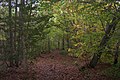
 Bridleway in Ellenden Wood (2) - geograph.org.uk - 1559711.jpg 640 × 427; 122 KB
-
 Bridleway in Ellenden Wood - geograph.org.uk - 1559616.jpg 640 × 427; 109 KB
-
 Bridleway in Tong Wood - geograph.org.uk - 1559717.jpg 640 × 427; 126 KB
-
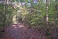
 Bridleway junction in Ellenden Wood (1) - geograph.org.uk - 1559602.jpg 640 × 427; 121 KB
-
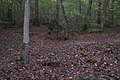
 Bridleway junction in Ellenden Wood (2) - geograph.org.uk - 1559611.jpg 640 × 427; 124 KB
-
 Closed Restaurant on A299 Thanet Way - geograph.org.uk - 1517089.jpg 640 × 427; 32 KB
-
 Culvert Drain in Ellenden Wood - geograph.org.uk - 1559629.jpg 640 × 427; 90 KB
-

-
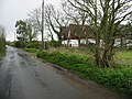
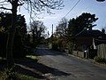 Dargate Road, Yorkletts - geograph.org.uk - 610703.jpg 640 × 480; 83 KB
-
 Ellenden Farm pond and three geese - geograph.org.uk - 1559580.jpg 640 × 427; 98 KB
-
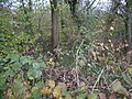
 Entering Ellenden Wood - geograph.org.uk - 1559588.jpg 640 × 427; 123 KB
-
 Fox's Cross - geograph.org.uk - 1559517.jpg 640 × 427; 99 KB
-
 Fox's Cross Bottom - geograph.org.uk - 340095.jpg 640 × 483; 88 KB
-
 Fox's Cross Bottom - geograph.org.uk - 340102.jpg 640 × 480; 106 KB
-
 Fox's Cross Bottom valley - geograph.org.uk - 1559507.jpg 640 × 427; 64 KB
-
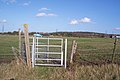
 Kissing Gate near Brookdene Farm - geograph.org.uk - 1559380.jpg 640 × 427; 96 KB
-
 Kissing Gates and Blue Car - geograph.org.uk - 1559386.jpg 640 × 427; 71 KB
-
 Looking SE along Fox's Cross Road - geograph.org.uk - 759310.jpg 640 × 480; 211 KB
-
 Looking W along Pye Alley Lane - geograph.org.uk - 758990.jpg 640 × 480; 176 KB
-
 Plumpudding Lane, Highstreet, Kent - geograph.org.uk - 1169069.jpg 640 × 480; 70 KB
-
 Pylons off Seasalter Lane - geograph.org.uk - 610720.jpg 480 × 640; 81 KB
-
 Road junction on Dargate Road - geograph.org.uk - 1559501.jpg 640 × 427; 84 KB
-

-
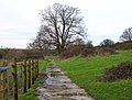
 Rubble lined footpath to Seasalter Lane - geograph.org.uk - 1559416.jpg 640 × 427; 123 KB
-
-
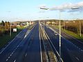
 Sliproad off the A299 Thanet Way - geograph.org.uk - 1559481.jpg 640 × 427; 86 KB
-
 Stile and Gate near Highstreet - geograph.org.uk - 1559353.jpg 640 × 427; 95 KB
-
 Thanet Way viaduct - geograph.org.uk - 339797.jpg 640 × 490; 80 KB
-
 View from Ellenden Wood - geograph.org.uk - 1559597.jpg 640 × 427; 56 KB
-
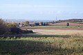
 View from footpath near Wraik Hill - geograph.org.uk - 1559563.jpg 640 × 420; 48 KB
-
 View of Hern Hill Nursery - geograph.org.uk - 1559390.jpg 640 × 427; 45 KB
-

-
 West across Seasalter Levels - geograph.org.uk - 340079.jpg 480 × 640; 92 KB
-
 Wraik Hill Information Board - geograph.org.uk - 1559549.jpg 640 × 427; 90 KB
-
 Wraik Hill Nature Reserve Car Park - geograph.org.uk - 1559540.jpg 640 × 427; 83 KB
-

-

-
 Coombe Wood, Yorkletts - geograph.org.uk - 617137.jpg 640 × 480; 146 KB
-
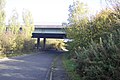
 Dargate Road under the Thanet Way - geograph.org.uk - 610714.jpg 640 × 480; 65 KB
-

-
 Services on the Thanet Way - geograph.org.uk - 336501.jpg 640 × 482; 66 KB


_-_geograph.org.uk_-_1559711.jpg)


_-_geograph.org.uk_-_1559602.jpg)
_-_geograph.org.uk_-_1559611.jpg)


