Cullercoats Metro station
Jump to navigation
Jump to search
English: Cullercoats 55°02′06″N 1°26′11″W / 55.035°N 1.4363°W is a station on the Yellow Line of the Tyne and Wear Metro, serving Cullercoats on the North Sea coast.
| Opened | New or converted |
Number of platforms | Track alignment | Tyne & Wear metropolitan borough |
| 11 August 1980 | Converted | 2 | NNW-SSE | North Tyneside |
| Layout | ||||
| Two side platforms at ground level with platform level station buildings along their full length | ||||
| Platform no. and position |
Direction of travel |
Previous stop |
Route | Next stop |
| Platform 1 West |
Northbound | Tynemouth | Yellow Line to South Shields (stop 14 of 42) | Whitley Bay |
| Platform 2 East |
Southbound | Whitley Bay | Yellow Line to St James (stop 29 of 42) | Tynemouth |
| Notes | ||||
| None | ||||
| Station buildings | ||||
| The original old red brick station building/walls, 100' long on both platforms | ||||
| Access | ||||
| Station forecourt to the east, at the west end of Station Road; footpath SW to St George's Road (Cullercoats Library); with the platforms connected by a footbridge at the southern end | ||||
| Protection from the elements | ||||
| 120' platform canopies attached to both station buildings | ||||
| Interchanges | ||||
| None | ||||
-
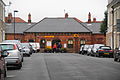 The view west to the outside of the Platform 2 building, along Station Road
5 April 2012 -
 The view west to the outside of the Platform 2 building
10 April 2005 -
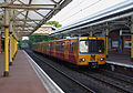
 The view from the front of Metrocar No. 4089 as it approaches Platform 1
10 October 2005 -
 The view north along Platform 1, with Metrocar No. 4071 seen in Platform 2 forming the front half of a train bound for St James
9 February 2010 -
 The view north along Platform 1, with Metrocar No. 4045 seen in Platform 2 forming the front half of a train bound for St James
23 May 2012 -
 The view north along Platform 1 as a train departs Platform 1 en route to South Shields, while another stands in Platform 2
6 January 2010 -
 The view north east from the south end of Platform 1, under the station footbridge and across to Platform 2
6 January 2010 -
 The view south along Platform 2, with Metrocar No. 4006 seen in Platform 1 forming the front half of a train bound for South Shields
23 May 2012 -
 The station footbridge (south side)
24 July 2006 -
 The station footbridge (interior)
24 July 2006 -
 The station footbridge (interior)
21 January 2011

_-_geograph.org.uk_-_595938.jpg)


.jpg)
.jpg)
.jpg)
.jpg)
.jpg)
.jpg)
