File:Free Trade Areas.PNG
Jump to navigation
Jump to search

Size of this preview: 800 × 352 pixels. Other resolutions: 320 × 141 pixels | 640 × 281 pixels | 1,428 × 628 pixels.
Original file (1,428 × 628 pixels, file size: 67 KB, MIME type: image/png)
Captions
Captions
Add a one-line explanation of what this file represents
Summary[edit]
| Description |
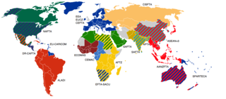
English: Free trade areas are a difficult subject. It is impossible to map all the existing free trade agreements on one map, and still make it readable. Here are presented FTAs with three or more participants. |
||
| Date | |||
| Source | Primarily based on the WTO list with exceptions for AFTZ, ASEAN+3 and AANZFTA. | ||
| Author | Emilfaro | ||
| Permission (Reusing this file) |
|
||
| Other versions |
 |
File history
Click on a date/time to view the file as it appeared at that time.
| Date/Time | Thumbnail | Dimensions | User | Comment | |
|---|---|---|---|---|---|
| current | 18:40, 10 July 2020 | | 1,428 × 628 (67 KB) | Maphobbyist (talk | contribs) | The UK left the EU and the customs union as well. |
| 16:17, 5 November 2017 |  | 1,428 × 628 (65 KB) | 5k8421 (talk | contribs) | Updated | |
| 22:07, 15 October 2017 |  | 1,428 × 628 (65 KB) | A.h. king (talk | contribs) | Updated. | |
| 14:34, 9 July 2011 |  | 1,428 × 628 (85 KB) | Wiz9999 (talk | contribs) | South Sudan Independence, Fixing Ethiopian artifact | |
| 15:06, 21 April 2010 |  | 1,428 × 628 (67 KB) | IJA (talk | contribs) | Correct boarders with Israel and Gaza, Armenia and Azerbaijan, Croatia and Bosnia, Serbia, Montenegro and Kosovo, and Ireland and the UK. Also added Crown dependencies in grey. | |
| 14:56, 7 February 2009 |  | 1,357 × 628 (69 KB) | Wiz9999 (talk | contribs) | Algeria is a part of GAFTA as of 2005 | |
| 00:46, 7 January 2009 |  | 1,357 × 628 (84 KB) | Emilfaro (talk | contribs) | AANZFTA-ASEAN+3 should be red. It is APTA and SPARTECA that overlap it. | |
| 10:59, 3 January 2009 |  | 1,357 × 628 (85 KB) | Emilfaro (talk | contribs) | Belize and Panama corrected. | |
| 21:47, 1 January 2009 |  | 1,357 × 628 (85 KB) | Emilfaro (talk | contribs) | {{Information |Description={{en|1=[http://en.wikipedia.org/wiki/Free_trade_area Free trade areas] are a difficult subject. It is impossible to map all the existing free trade agreements on one map, and still make it readable. Here are presented FTAs with |
You cannot overwrite this file.
File usage on Commons
The following 2 pages use this file:
- File:Customs unions.png
- File:Free Trade Areas.png (file redirect)
File usage on other wikis
The following other wikis use this file:
- Usage on ar.wikipedia.org
- Usage on be.wikipedia.org
- Usage on cv.wikipedia.org
- Usage on da.wikipedia.org
- Usage on en.wikipedia.org
- Usage on eo.wikipedia.org
- Usage on es.wikinews.org
- Usage on fa.wikipedia.org
- Usage on fi.wikipedia.org
- Usage on fr.wikipedia.org
- Usage on fr.wikiversity.org
- Usage on he.wikipedia.org
- Usage on hi.wikipedia.org
- Usage on id.wikipedia.org
- Usage on io.wikipedia.org
- Usage on it.wikipedia.org
- Usage on ja.wikipedia.org
- Usage on ko.wikipedia.org
- Usage on ms.wikipedia.org
- Usage on nl.wikipedia.org
- Usage on no.wikipedia.org
- Usage on sv.wikipedia.org
- Usage on vi.wikipedia.org
- Usage on zh.wikipedia.org
View more global usage of this file.