File:Irland karte.png
Jump to navigation
Jump to search
Size of this preview: 503 × 600 pixels. Other resolutions: 201 × 240 pixels | 402 × 480 pixels | 644 × 768 pixels | 858 × 1,024 pixels | 1,473 × 1,757 pixels.
Original file (1,473 × 1,757 pixels, file size: 1.25 MB, MIME type: image/png)
Captions
Captions
Add a one-line explanation of what this file represents
|
| Description |
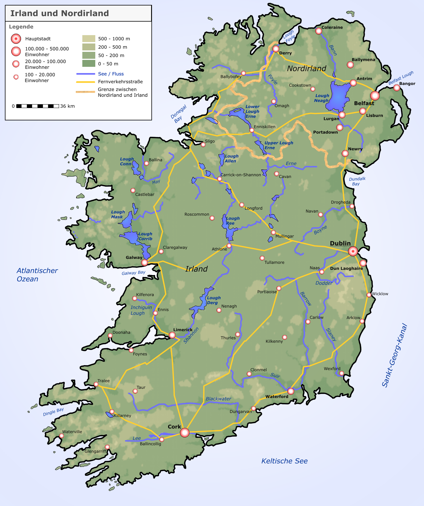
Deutsch: Neue Karte von Irland und Nordirland |
| Date | |
| Source |
selbst erstellt von Roger Zenner
|
| Author | Roger Zenner |
| Permission (Reusing this file) |
CC-by-sa-2.0-de |
| Other versions |
copied from de.wikipedia [1]:
|
![[1]](https://de.wikipedia.org/wiki/Bild:Irland_karte.png)
This file is licensed under the Creative Commons Attribution-Share Alike 2.0 Germany license.
- You are free:
- to share – to copy, distribute and transmit the work
- to remix – to adapt the work
- Under the following conditions:
- attribution – You must give appropriate credit, provide a link to the license, and indicate if changes were made. You may do so in any reasonable manner, but not in any way that suggests the licensor endorses you or your use.
- share alike – If you remix, transform, or build upon the material, you must distribute your contributions under the same or compatible license as the original.


|
This map image could be re-created using vector graphics as an SVG file. This has several advantages; see Commons:Media for cleanup for more information. If an SVG form of this image is available, please upload it and afterwards replace this template with
{{vector version available|new image name}}.
It is recommended to name the SVG file “Irland karte.svg”—then the template Vector version available (or Vva) does not need the new image name parameter. |
File history
Click on a date/time to view the file as it appeared at that time.
| Date/Time | Thumbnail | Dimensions | User | Comment | |
|---|---|---|---|---|---|
| current | 09:05, 17 September 2005 | | 1,473 × 1,757 (1.25 MB) | Saperaud~commonswiki (talk | contribs) | neue Karte von Irland und Nordirland Lizenz: Das Bild wurde von Benutzer:Roger_Zenner gezeichnet und wurde unter der CC-by-sa/2.0/de veröffentlicht. *Version 1.6: Höhenstufen weicher *Version 1.5: Londonderry heißt nun Derry, Beschriftungen angep |
You cannot overwrite this file.
File usage on Commons
The following 66 pages use this file:
- Ireland
- Commons:Featured picture candidates/File:Irland karte.png
- Category:1147 in Ireland
- Category:1182 in Ireland
- Category:1253 in Ireland
- Category:1269 in Ireland
- Category:Alumni by university or college in Ireland
- Category:Archbishops in Ireland
- Category:Association football coaches from the Republic of Ireland
- Category:Association football goalkeepers from Ireland
- Category:Association football in Ireland
- Category:Athletics in Ireland
- Category:Badminton in Ireland
- Category:Baronets in the Baronetage of Ireland
- Category:Bays of Ireland
- Category:Beauty pageants in Ireland
- Category:Births in Ireland
- Category:Bodies of water in Ireland
- Category:Bridges in Ireland
- Category:Burials in Ireland
- Category:Cable-stayed bridges in Ireland
- Category:Cities in Ireland
- Category:Civil servants of Ireland
- Category:Clootie trees in Ireland
- Category:Death in Ireland
- Category:Deaths in Ireland
- Category:Drag queens from Ireland
- Category:Entertainment venues in Ireland
- Category:Footbridges in Ireland
- Category:Franciscans from Ireland
- Category:Fungi of Ireland
- Category:Hiking trails in the Republic of Ireland
- Category:History of Ireland by county
- Category:Human rights activists from Ireland
- Category:Hunting in Ireland
- Category:Interchanges in Ireland
- Category:Ireland
- Category:Ireland in the 12th century
- Category:Ireland in the 13th century
- Category:Ireland in the 14th century
- Category:Ireland in the 15th century
- Category:Ireland in the 1600s
- Category:Ireland in the 1610s
- Category:Ireland in the 1660s
- Category:Ireland in the 1680s
- Category:Ireland in the 1690s
- Category:Ireland in the 16th century
- Category:Ireland in the 17th century
- Category:Ireland in the 1810s
- Category:Ireland in the 18th century
- Category:Islands of Ireland
- Category:Landforms of Ireland
- Category:Male sportspeople from Ireland
- Category:Maps of Ireland
- Category:Mountain passes of Ireland
- Category:Mountaineering in Ireland
- Category:Passenger ships of Ireland
- Category:Plays from Ireland
- Category:Railway bridges in the Republic of Ireland
- Category:Railway lines in Ireland
- Category:Ramsar sites in Ireland
- Category:Road transport infrastructure in Ireland
- Category:Snow in Ireland
- Category:Sports venues in Ireland
- Category:Templates related to Ireland
- Category:Valleys of Ireland
File usage on other wikis
The following other wikis use this file:
- Usage on ar.wikipedia.org
- Usage on ca.wikipedia.org
- Usage on cs.wikipedia.org
- Usage on da.wikipedia.org
- Usage on de.wikipedia.org
- Irland (Insel)
- Irland
- Wikipedia:Kandidaten für exzellente Bilder/Archiv2004/4
- Benutzer:Roger Zenner/Bilder
- Datei:Irland karte.png
- Benutzer:Cmoder/Grafiktipps
- Wikipedia:Exzellente Bilder/Karten und Satellitenbilder
- Benutzer:Uwe Dedering/Länderliste
- Benutzer:Ulflulfl/Karten
- Vorlage:Infobox Insel/Erprobung Karte in einer Ecke
- Vorlage:Infobox Insel/Erprobung Karte in einer Ecke/Doku
- Usage on de.wiktionary.org
- Usage on eo.wikipedia.org
- Usage on et.wikipedia.org
- Usage on frr.wikipedia.org
- Usage on fr.wikipedia.org
- Usage on ga.wikipedia.org
- Usage on hy.wikipedia.org
- Usage on kab.wikipedia.org
- Usage on lb.wikipedia.org
- Usage on pfl.wikipedia.org
- Usage on pl.wikipedia.org
- Shannon (rzeka)
- Geografia Irlandii
- Boyne
- Lee (rzeka w Irlandii)
- Wikipedysta:DodekBot/lista-de
- Wikipedysta:DodekBot/lista-de2
- Corrib
- Liffey
- Blackwater (Meath)
- Slaney
- Munster Blackwater
- Barrow (rzeka)
- Brosna (rzeka)
- Suir
- Nore
- Erne
- Camac
- Tolka
- Dodder
- Mulkear
- Laune
- Blackwater (Kerry)
- Blackwater (Ulster)
- Finn (rzeka)
View more global usage of this file.