File:Map Macedonia 336 BC-es.svg
Jump to navigation
Jump to search

Size of this PNG preview of this SVG file: 749 × 600 pixels. Other resolutions: 300 × 240 pixels | 600 × 480 pixels | 960 × 768 pixels | 1,279 × 1,024 pixels | 2,559 × 2,048 pixels | 992 × 794 pixels.
Original file (SVG file, nominally 992 × 794 pixels, file size: 3.41 MB)
Captions
Captions
Add a one-line explanation of what this file represents
| Description |
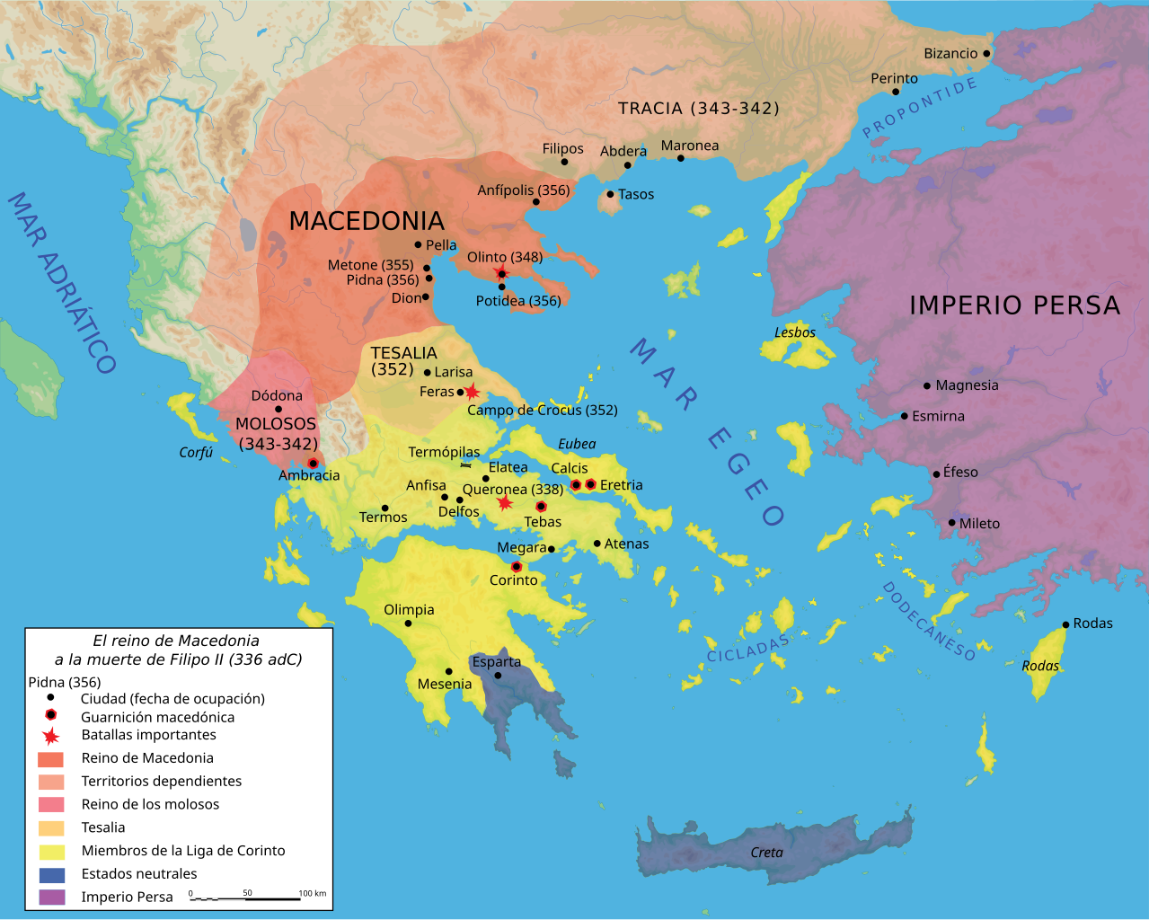
Español: Mapa del reino de Filipo II a su muerte, 336 adC |
||||||||
| Date | |||||||||
| Source |
Own work using Adobe Illustrator (data from R. Ginouvès and al., La Macédoine, Paris, 1992). Translated from Image:Map Macedonia 336 BC-fr.svg. |
||||||||
| Author | Marsyas; Kordas | ||||||||
| Permission (Reusing this file) |
I, the copyright holder of this work, hereby publish it under the following licenses:
This file is licensed under the Creative Commons Attribution-Share Alike 2.5 Generic license.
You may select the license of your choice. |
||||||||
| Other versions |
[]
|


|
This SVG file contains embedded text that can be translated into your language, using any capable SVG editor, text editor or the SVG Translate tool. For more information see: About translating SVG files. |
File history
Click on a date/time to view the file as it appeared at that time.
| Date/Time | Thumbnail | Dimensions | User | Comment | |
|---|---|---|---|---|---|
| current | 22:24, 27 June 2007 | | 992 × 794 (3.41 MB) | Bibi Saint-Pol (talk | contribs) | fix several SVG problems; restore legend: this is part of the map |
| 08:11, 20 March 2017 |  | 1,058 × 847 (4.07 MB) | Rowanwindwhistler (talk | contribs) | https://en.wikipedia.org/wiki/Wikipedia:WikiProject_Maps/Conventions Fake text added | |
| 07:36, 25 February 2016 |  | 992 × 794 (3.59 MB) | Rowanwindwhistler (talk | contribs) | Cleaner version, height per layer for easier modification, duplication of islands removed. | |
| 06:56, 25 February 2016 |  | 992 × 794 (3.06 MB) | Rowanwindwhistler (talk | contribs) | Battle symbols on top | |
| 09:28, 22 February 2016 |  | 992 × 794 (3.06 MB) | Rowanwindwhistler (talk | contribs) | Eubea corrected | |
| 19:20, 29 December 2015 |  | 992 × 794 (3.06 MB) | Rowanwindwhistler (talk | contribs) | No transparency for the sea | |
| 19:17, 29 December 2015 |  | 992 × 794 (3.06 MB) | Rowanwindwhistler (talk | contribs) | Coast added, sea colour changed as per https://en.wikipedia.org/wiki/Wikipedia:WikiProject_Maps/Conventions | |
| 22:29, 27 June 2007 |  | 992 × 794 (3.41 MB) | Bibi Saint-Pol (talk | contribs) | {{Information |Description= {{es|Mapa del reino de Filipo II a su muerte, 336 adC}} Source=Own work using Adobe Illustrator (data from R. Ginouvès and al., ''La Macédoine'', Paris, 1992). Translated from [[:Image:Map Macedonia 336 | |
| 23:54, 13 June 2007 |  | 993 × 794 (3.43 MB) | Ignacio Icke (talk | contribs) | -legend off | |
| 23:29, 12 June 2007 |  | 993 × 794 (3.43 MB) | Ignacio Icke (talk | contribs) | trying to solve the rectangles thing |
You cannot overwrite this file.
File usage on Commons
The following 18 pages use this file:
- File:Karte Makedonien 336 vC-de.svg
- File:Macedonia y Grecia (336 adC).svg (file redirect)
- File:Map Macedonia 336 BC-ar.svg
- File:Map Macedonia 336 BC-bg.svg
- File:Map Macedonia 336 BC-ce.svg
- File:Map Macedonia 336 BC-de.svg
- File:Map Macedonia 336 BC-en.svg
- File:Map Macedonia 336 BC-es.svg
- File:Map Macedonia 336 BC-fr.svg
- File:Map Macedonia 336 BC-he-2.svg
- File:Map Macedonia 336 BC-he.svg
- File:Map Macedonia 336 BC-it.svg
- File:Map Macedonia 336 BC-ka.svg
- File:Map Macedonia 336 BC-pt.svg
- File:Map Macedonia 336 BC-ru.svg
- File:Map Macedonia 336 BC-zh.svg
- File:மாசிடோனியா கி. மு. 336.svg
- Template:Other versions/Map Macedonia 336 BC
.svg&redirect=no)
File usage on other wikis
The following other wikis use this file:
- Usage on ast.wikipedia.org
- Usage on es.wikipedia.org
- Usage on eu.wikipedia.org
- Usage on gl.wikipedia.org
- Usage on hu.wikipedia.org
- Usage on la.wikipedia.org
- Usage on pl.wikipedia.org
- Usage on sq.wikipedia.org