File:The Neck Bruny Island.jpg
Jump to navigation
Jump to search

Size of this preview: 399 × 599 pixels. Other resolutions: 160 × 240 pixels | 319 × 480 pixels | 511 × 768 pixels | 681 × 1,024 pixels | 1,300 × 1,953 pixels.
Original file (1,300 × 1,953 pixels, file size: 3.53 MB, MIME type: image/jpeg)
Captions
Captions
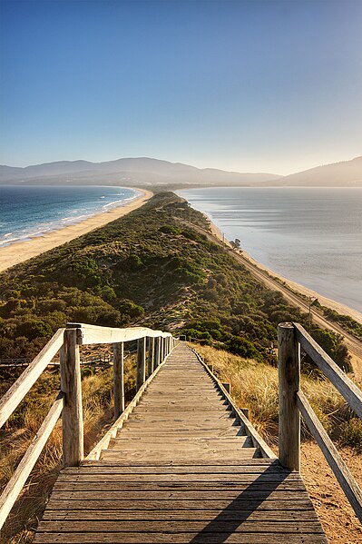
The sandy isthmus or tombolo "The Nack" connecting North and South Bruny Island in Tasmania, Australia
|

This image was selected as picture of the day on Wikimedia Commons for 9 May 2009. It was captioned as follows: English: The Spit, Bruny Island, Tasmania, Australia Other languages:
Afrikaans: "Die Nek" verbind die twee helftes van Brunyeiland aan die suidkus van Tasmanië, en is 'n belangrike broeiplek vir seevoëls Bosanski: Prevlaka (povezuje dva dijela ostrva) na ostrvu Bruny. U australijskoj državi Tasmanija. Dansk: The Spit på Bruny Island i Tasmanien English: The Spit, Bruny Island, Tasmania, Australia Español: The Spit, Bruny Island, Tasmania, Australia Nederlands: "The Spit" op Brunyeiland nabij het Australische eiland Tasmanië Română: „The Spit”, Insula Bruny, Tasmania, Australia Suomi: "The Spit" Bruny-saarella, Tasmaniassa, Australiassa. Македонски: Превлака на островот Бруни во Тасманија, Австралија 한국어: 오스트레일리아 태즈메이니아의 브루니섬에 있는 The Spit 中文(繁體): 澳洲塔斯馬尼亞布魯尼島風景 |
Summary[edit]
| Description |
English: The Neck, Bruny Island, Tasmania, Australia.
Français : Vue de l'Isthme Saint-Aignant (nommé « The Neck » par les locaux anglophones) sur l'Île Bruny, en Tasmanie (Australie).
|
| Date | |
| Source | Own work |
| Author | JJ Harrison (https://www.jjharrison.com.au/) |
| Permission (Reusing this file) |
I, the copyright holder of this work, hereby publish it under the following license: This file is licensed under the Creative Commons Attribution-Share Alike 2.5 Generic license.
Own work, share alike, attribution required (Creative Commons CC-BY-SA-2.5) |
| Other versions |
 |
| Camera location | | View this and other nearby images on: OpenStreetMap |
|---|
| This is a retouched picture, which means that it has been digitally altered from its original version. Modifications: Flare and dust spots removed (see first revision for original).
|
File history
Click on a date/time to view the file as it appeared at that time.
| Date/Time | Thumbnail | Dimensions | User | Comment | |
|---|---|---|---|---|---|
| current | 23:40, 22 January 2009 | | 1,300 × 1,953 (3.53 MB) | Papa Lima Whiskey (talk | contribs) | srgb conversion |
| 00:28, 22 January 2009 |  | 1,300 × 1,953 (1.94 MB) | JJ Harrison (talk | contribs) | dust spot, flare removed | |
| 11:47, 21 January 2009 |  | 1,300 × 1,953 (3.25 MB) | JJ Harrison (talk | contribs) | ||
| 03:41, 21 January 2009 |  | 1,300 × 1,953 (1.95 MB) | JJ Harrison (talk | contribs) | {{Information |Description=The Spit, Bruny Island, Tasmania, Australia |Source=Own work |Date=14/01/2009 |Author=Noodle snacks |Permission=Own work, share alike, attribution required (Creative Commons CC-BY-SA-2.5) |other_versions= |
You cannot overwrite this file.
File usage on Commons
More than 100 pages use this file. The following list shows the first 100 pages that use this file only. A full list is available.
- User:Hartwin Wolf/Gallery:miscellany
- User:JJ Harrison/gallery2
- User:Lupo/iat
- User:Ö/Best/2009
- User talk:Norro
- Commons:Featured picture candidates/File:The Spit Bruny Island.jpg
- Commons:Featured picture candidates/Log/February 2009
- Commons:Featured pictures/Places/Natural/Australia
- Commons:Featured pictures/chronological/2009-A
- Commons:Photography critiques/May 2017
- Commons:Picture of the Year/2009/Galleries/2009-A
- Commons:Picture of the Year/2009/Galleries/All
- Commons:Picture of the Year/2009/Galleries/Index/2
- Commons:Picture of the Year/2009/Galleries/Index/Nature views
- Commons:Picture of the Year/2009/Galleries/Nature views
- Commons:Picture of the Year/2009/Galleries/Nature views/1
- Commons:Picture of the Year/2009/Galleries/Table/200902
- Commons:Picture of the Year/2009/R1/File:The Spit Bruny Island.jpg
- Commons:Picture of the Year/2009/Results/R1/ALL/Table
- Commons:Picture of the Year/2009/Results/R1/Nature views
- Commons:Picture of the Year/2009/Results/R1/Nature views/Table
- Commons:Potd/2009-05 (da)
- Commons:Potd/2009-05 (de)
- Commons:Potd/2009-05 (eo)
- Commons:Potd/2009-05 (nl)
- Commons:Potd/2009-05 (pt)
- Commons:Potd/2009-05 (tr)
- Commons:Village pump/Archive/2013/09
- File:Bruny Island banner 1.jpg
- File:The Neck Bruny Island.jpg
- File:The Spit Bruny Island.jpg (file redirect)
- User talk:Norro
- Commons:Potd/2009-05 (pt)
- Commons:Featured picture candidates/Log/February 2009
- Commons:Featured pictures/chronological/2009-A
- Template:Potd/2009-05
- Commons:Potd/2009-05 (de)
- File:The Neck Bruny Island.jpg
- File:The Spit Bruny Island edit.jpg
- Commons:Featured picture candidates/File:The Spit Bruny Island.jpg
- Commons:Potd/2009-05 (eo)
- Template:Potd/2009-05 (zh-hans)
- Template:Potd/2009-05-09
- Template:Potd/2009-05-09 (en)
- Template:Potd/2009-05-09 (pt)
- Template:Potd/2009-05-09 (de)
- Template:Potd/2009-05-09 (af)
- Template:Potd/2009-05 (ro)
- Commons:Potd/2009-05 (tr)
- Template:Potd/2009-05-09 (bs)
- Commons:Potd/2009-05 (nl)
- Template:Potd/2009-05-09 (fr)
- Template:Potd/2009-05-09 (zh-hans)
- Template:Potd/2009-05-09 (zh-hant)
- Template:Potd/2009-05-09 (nl)
- Template:Potd/2009-05-09 (mk)
- Template:Potd/2009-05-09 (ro)
- Template:Potd/2009-05-09 (ru)
- Template:Potd/2009-05-09 (it)
- Template:Potd/2009-05-09 (hu)
- Template:Potd/2009-05-09 (da)
- Template:Potd/2009-05-09 (ko)
- Template:Potd/2009-05-09 (fi)
- Template:Potd/2009-05-09 (pam)
- Template:Potd/2009-05-09 (cs)
- Template:Potd/2009-05-09 (ja)
- Template:Potd/2009-05-09 (pl)
- Commons:Picture of the Year/2009/Galleries/Table/200902
- Commons:Picture of the Year/2009/Galleries/Nature views
- Commons:Picture of the Year/2009/Galleries/All
- Commons:Picture of the Year/2009/Galleries/2009-A
- Commons:Picture of the Year/2009/Galleries/Nature views/1
- Commons:Picture of the Year/2009/Galleries/Index/2
- Commons:Picture of the Year/2009/R1/File:The Spit Bruny Island.jpg
- File:The Spit Bruny Island edit.jpg
- Template:Potd/2009-05
- Template:Potd/2009-05-09
- Template:Potd/2009-05-09 (af)
- Template:Potd/2009-05-09 (bs)
- Template:Potd/2009-05-09 (cs)
- Template:Potd/2009-05-09 (da)
- Template:Potd/2009-05-09 (de)
- Template:Potd/2009-05-09 (en)
- Template:Potd/2009-05-09 (es)
- Template:Potd/2009-05-09 (fi)
- Template:Potd/2009-05-09 (fr)
- Template:Potd/2009-05-09 (hu)
- Template:Potd/2009-05-09 (it)
- Template:Potd/2009-05-09 (ja)
- Template:Potd/2009-05-09 (ko)
- Template:Potd/2009-05-09 (mk)
- Template:Potd/2009-05-09 (nl)
- Template:Potd/2009-05-09 (pam)
- Template:Potd/2009-05-09 (pl)
- Template:Potd/2009-05-09 (pt)
- Template:Potd/2009-05-09 (ro)
- Template:Potd/2009-05-09 (ru)
- Template:Potd/2009-05-09 (zh-hans)
- Template:Potd/2009-05-09 (zh-hant)
- Template:Potd/2009-05 (ro)
View more links to this file.
File usage on other wikis
The following other wikis use this file:
- Usage on ar.wikipedia.org
- Usage on ast.wikipedia.org
- Usage on bcl.wikipedia.org
- Usage on bn.wikipedia.org
- Usage on br.wikipedia.org
- Usage on ca.wikipedia.org
- Usage on crh.wikipedia.org
- Usage on cv.wikipedia.org
- Usage on da.wikipedia.org
- Usage on de.wikipedia.org
- Portal:Geographie
- Isthmus (Geographie)
- Portal Diskussion:Geographie/Bild des Monats
- Benutzer:SchirmerPower
- Wikipedia:Exzellente Bilder/Landschaften
- Benutzer:Überraschungsbildervertretung
- Benutzer:Bdk/WB
- Wikipedia:Kandidaten für exzellente Bilder/Archiv2009/3
- Datei:The Neck Bruny Island.jpg
- Benutzer:Jonny7
- Benutzer:SupapleX
- Benutzer:Der Wolf im Wald/Lieblingsbilder
- Benutzer:Matt1971/Wikipedia intern/Entdecken/Bilderselektionen der Portale
- Portal:Geographie/Bild des Monats/04
- Benutzer:EdgarvonSchleck/Bilder
- Benutzer:Geheimnisenthüller/Bildergalerie/Monatlich wechselnde Bilder
- Usage on de.wiktionary.org
- Usage on en.wikipedia.org
- Isthmus
- Bruny Island
- User:Kerowyn
- Wikipedia:Featured pictures/Places/Landscapes
- User:Seresin/Pictures
- User:Papa Lima Whiskey
- User:Shootbamboo
- Wikipedia:Featured pictures thumbs/15
- User:JJ Harrison/gallery
- Wikipedia:Featured picture candidates/File:The Spit Bruny Island.jpg
- Wikipedia:Featured picture candidates/February-2009
- Wikipedia:Wikipedia Signpost/2009-02-08/Features and admins
- User talk:JJ Harrison/Archive1
- Wikipedia:Picture of the day/November 2009
- Template:POTD/2009-11-24
- User:IBen/Editnotice
- User talk:JJ Harrison/Archive3
- User:Theleftorium
- Wikipedia:Wikipedia Signpost/2009-02-08/SPV
- Wikipedia:Wikipedia Signpost/Single/2009-02-08
- Usage on en.wikivoyage.org
View more global usage of this file.