File:1746 Homann Heirs Map of South ^ North America - Geographicus - Americae-hmhr-1746.jpg
Jump to navigation
Jump to search

Size of this preview: 686 × 599 pixels. Other resolutions: 275 × 240 pixels | 550 × 480 pixels | 879 × 768 pixels | 1,172 × 1,024 pixels | 2,345 × 2,048 pixels | 4,000 × 3,494 pixels.
Original file (4,000 × 3,494 pixels, file size: 3.91 MB, MIME type: image/jpeg)
Captions
Captions
Add a one-line explanation of what this file represents
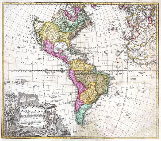
| Americae Mappa Generalis. | ||||||
|---|---|---|---|---|---|---|
| Artist | ||||||
| Title |
Americae Mappa Generalis. |
|||||
| Description |
English: A stunning 1746 Homann Heirs hand colored map of both North and South America. This is the second issue of this important map following the earlier edition by J. B. Homann. Map reflects a considerable advancement in American cartography of the time as well as a general increase in knowledge regarding America’s interior from explorations and colonizations. Map immediately precedes the French and Indian War, so the French are shown to dominate North American while the Spanish are preeminent in the south. The Pacific Northwest is largely unexplored, but nonetheless, the mythical Northwest Passage is shown. As is the mythical Quivira, “Land of Gold and Silver”, sought after by conquistador Francisco de Coronado in 1541. The beautiful decorative title cartouche in the lower left quadrant depicts two erupting volcanoes and several American Indians, one of which is seems to be holding aloft a shrunken head or similar idol. An important early map of the Americas. |
|||||
| Date | 1746 | |||||
| Dimensions | height: 18.5 in (46.9 cm); width: 21.5 in (54.6 cm) | |||||
| Accession number |
Geographicus link: Americae-hmhr-1746 |
|||||
| Source/Photographer |
|
|||||
| Permission (Reusing this file) |
|
|||||
File history
Click on a date/time to view the file as it appeared at that time.
| Date/Time | Thumbnail | Dimensions | User | Comment | |
|---|---|---|---|---|---|
| current | 09:15, 24 March 2011 | | 4,000 × 3,494 (3.91 MB) | BotMultichillT (talk | contribs) | {{subst:User:Multichill/Geographicus |link=http://www.geographicus.com/P/AntiqueMap/Americae-hmhr-1746 |product_name=1746 Homann Heirs Map of South & North America |map_title=Americae Mappa Generalis. |description=A stunning 1746 Homann Heirs hand colored |
You cannot overwrite this file.
File usage on Commons
The following page uses this file:
File usage on other wikis
The following other wikis use this file:
- Usage on ja.wikipedia.org