File:1839 Monin Map of the Hebrew Peoples Dispersal After the Flood - Geographicus - PeoplesDispersal-monin-1839.jpg
Jump to navigation
Jump to search

Size of this preview: 785 × 600 pixels. Other resolutions: 314 × 240 pixels | 629 × 480 pixels | 1,006 × 768 pixels | 1,280 × 978 pixels | 2,560 × 1,955 pixels | 3,500 × 2,673 pixels.
Original file (3,500 × 2,673 pixels, file size: 2.71 MB, MIME type: image/jpeg)
Captions
Captions
Add a one-line explanation of what this file represents
| Charles V. Monin: French: Géographie des Hébreux et Tableau de la dispersion des peuples après le déluge. Corrigée et augmentée.
( |
||||||||||||||
|---|---|---|---|---|---|---|---|---|---|---|---|---|---|---|
| Artist |
|
|||||||||||||
| Title |
French:
Géographie des Hébreux et Tableau de la dispersion des peuples après le déluge. Corrigée et augmentée. |
|||||||||||||
| Description |
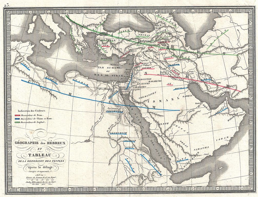
English: This is an 1839 C.V. Monin map of the Dispersal of the Hebrew Peoples After the Flood. This beautifully drawn map covers the lands occupied by the modern day countries of Turkey, Saudi Arabia, Egypt, Israel and Iraq. The travels the sons of Noah are indicated by color: the descendants of Sem (Shem) in red, the descendants of Ham in blue, and Japhet (Japheth) in green. Minor topographical detail shown, such as mountain ranges, and major cities labeled. Two scales shown in the lower left quadrant.
العربية: هذا عام 1839 م. خريطة مونين لتفريق الشعوب العبرية بعد الطوفان، تغطي هذه الخريطة المرسومة بشكل جميل الأراضي التي تحتلها الدول الحديثة في تركيا والمملكة العربية السعودية ومصر وإسرائيل والعراق. يشار إلى أسفار أبناء نوح بالألوان: أحفاد سيم (سام) باللون الأحمر، ونسل حام باللون الأزرق، ويافيت (جافث) باللون الأخضر. تم عرض تفاصيل طوبوغرافية طفيفة، مثل سلاسل الجبال والمدن الكبرى التي تحمل علامة. مقياسان موضحان في الربع السفلي الأيسر. |
|||||||||||||
| Date | circa 1838 (undated) | |||||||||||||
| Dimensions | height: 13 in (33 cm); width: 18 in (45.7 cm) | |||||||||||||
| Accession number |
Geographicus link: PeoplesDispersal-monin-1839 |
|||||||||||||
| Source/Photographer |
V. Monin: Atlas classique de la Géographie ancienne, du moyen age, et moderne. Nouvelle édition, Paris/Lyon: Perisse, [1838], pl. 23.
|
|||||||||||||
| Permission (Reusing this file) |
|
|||||||||||||
File history
Click on a date/time to view the file as it appeared at that time.
| Date/Time | Thumbnail | Dimensions | User | Comment | |
|---|---|---|---|---|---|
| current | 00:07, 25 March 2011 | | 3,500 × 2,673 (2.71 MB) | BotMultichillT (talk | contribs) | {{subst:User:Multichill/Geographicus |link=http://www.geographicus.com/P/AntiqueMap/PeoplesDispersal-monin-1839 |product_name=1839 Monin Map of the Hebrew Peoples Dispersal After the Flood |map_title=Geographie des Hebreux et Tableau de la Dispersion des |
You cannot overwrite this file.
File usage on Commons
The following page uses this file:
File usage on other wikis
The following other wikis use this file:
- Usage on ar.wikipedia.org
- Usage on ast.wikipedia.org
- Usage on es.wikipedia.org
- Usage on gl.wikipedia.org
- Usage on it.wikipedia.org