File:1852 Levasseur Map of the Department De Maine et Loire, France - Geographicus - MaineEtLoire-levasseur-1852.jpg
Jump to navigation
Jump to search

Size of this preview: 800 × 561 pixels. Other resolutions: 320 × 224 pixels | 640 × 449 pixels | 1,024 × 718 pixels | 1,280 × 898 pixels | 2,560 × 1,796 pixels | 3,500 × 2,455 pixels.
Original file (3,500 × 2,455 pixels, file size: 3.19 MB, MIME type: image/jpeg)
Captions
Captions
Add a one-line explanation of what this file represents
| Dept. de Maine et Loire. | ||||||||||||||||||||||||||||||||||||
|---|---|---|---|---|---|---|---|---|---|---|---|---|---|---|---|---|---|---|---|---|---|---|---|---|---|---|---|---|---|---|---|---|---|---|---|---|
| Artist |
|
|||||||||||||||||||||||||||||||||||
| Title |
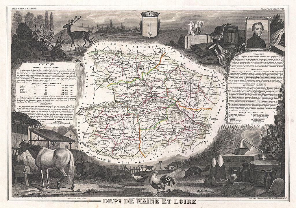
Dept. de Maine et Loire. |
|||||||||||||||||||||||||||||||||||
| Description |
English: This is a fascinating 1852 map of the French department of Maine et Loire, France. This area of France is part of the Loire Valley wine region, where nearly every wine imaginable is produced. Maine et Loire itself is home to the largest vineyard in the Loire Valley. It is also known for its production of Port-Salut, a distinctive, semi-soft cow’s milk cheese. The map proper is surrounded by elaborate decorative engravings designed to illustrate both the natural beauty and trade richness of the land. There is a short textual history of the regions depicted on both the left and right sides of the map. Published by V. Levasseur in the 1852 edition of his Atlas National de la France Illustree. |
|||||||||||||||||||||||||||||||||||
| Date | 1852 (undated) | |||||||||||||||||||||||||||||||||||
| Dimensions | height: 12 in (30.4 cm); width: 17 in (43.1 cm) | |||||||||||||||||||||||||||||||||||
| Accession number |
Geographicus link: MaineEtLoire-levasseur-1852 |
|||||||||||||||||||||||||||||||||||
| Source/Photographer |
Levassuer, V., Atlas National Illustre des 86 Departements et des Possessions de La France Divise par Arrondissements, Cantons et Communea avec La Trace de Toutes Les Routes, Chemins,de fer et Canaux., 1852 edition.
|
|||||||||||||||||||||||||||||||||||
| Permission (Reusing this file) |
|
|||||||||||||||||||||||||||||||||||
| Other versions |
|
|||||||||||||||||||||||||||||||||||

File history
Click on a date/time to view the file as it appeared at that time.
| Date/Time | Thumbnail | Dimensions | User | Comment | |
|---|---|---|---|---|---|
| current | 05:09, 24 March 2011 | | 3,500 × 2,455 (3.19 MB) | BotMultichillT (talk | contribs) | {{subst:User:Multichill/Geographicus |link=http://www.geographicus.com/P/AntiqueMap/MaineEtLoire-levasseur-1852 |product_name=1852 Levasseur Map of the Department De Maine et Loire, France |map_title=Dept. de Maine et Loire. |description=This is a fascina |
You cannot overwrite this file.
File usage on Commons
The following 2 pages use this file:
File usage on other wikis
The following other wikis use this file:
- Usage on fr.wikipedia.org
- Usage on fr.wiktionary.org