File:1862 Johnson Map of Kansas and Missouri - Geographicus - KAMO-johnson-1862.jpg
Jump to navigation
Jump to search

Size of this preview: 800 × 600 pixels. Other resolutions: 320 × 240 pixels | 640 × 480 pixels | 1,024 × 768 pixels | 1,280 × 959 pixels | 2,560 × 1,919 pixels | 5,000 × 3,748 pixels.
Original file (5,000 × 3,748 pixels, file size: 7.33 MB, MIME type: image/jpeg)
Captions
Captions
Add a one-line explanation of what this file represents
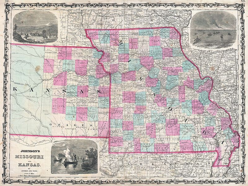
| Alvin Jewett Johnson: Johnson's Missouri and Kansas.
( |
|||||||||||||||||||||||
|---|---|---|---|---|---|---|---|---|---|---|---|---|---|---|---|---|---|---|---|---|---|---|---|
| Artist |
|
||||||||||||||||||||||
| Title |
Johnson's Missouri and Kansas. |
||||||||||||||||||||||
| Description |
English: A beautiful example of A. J. Johnson’s 1862 map of Missouri and Kansas. One of Johnson’s more decorative maps, this rare map offers a fascinating snapshot of these hotly contested states shortly following the outbreak of the American Civil War. Map shows all three states in full with color coding according to county. Offers three inset woodcuts: “Fire on the Prairie”, Santa Fe From the Great Missouri Trail” and American Indians “Spearing Fish” at night from river canoes. Depicts the two states in an early configuration with western Kansas largely unsurveyed. Notes important transcontinental routes such as the Santa Fe Road and the proposed route of the Union Pacific Railroad. Features the strapwork style border common to Johnson’s atlas work from 1860 to 1863. Published by A. J. Johnson and Ward as plate numbers 52 and 53 in the 1862 edition of Johnson’s New Illustrated Family Atlas . |
||||||||||||||||||||||
| Date | 1862 (undated) | ||||||||||||||||||||||
| Dimensions | height: 17.5 in (44.4 cm); width: 23.5 in (59.6 cm) | ||||||||||||||||||||||
| Accession number |
Geographicus link: KAMO-johnson-1862 |
||||||||||||||||||||||
| Source/Photographer |
Johnson, A. J., Johnson's New Illustrated (Steel Plate) Family Atlas with Descriptions, Geographical, Statistical, and Historical. (1862 A. J. Johnson & Ward edition)
|
||||||||||||||||||||||
| Permission (Reusing this file) |
|
||||||||||||||||||||||
File history
Click on a date/time to view the file as it appeared at that time.
| Date/Time | Thumbnail | Dimensions | User | Comment | |
|---|---|---|---|---|---|
| current | 20:41, 22 March 2011 | | 5,000 × 3,748 (7.33 MB) | BotMultichillT (talk | contribs) | {{subst:User:Multichill/Geographicus |link=http://www.geographicus.com/P/AntiqueMap/KAMO-johnson-1862 |product_name=1862 Johnson Map of Kansas and Missouri |map_title=Johnson's Missouri and Kansas. |description=A beautiful example of A. J. Johnson’s 18 |
You cannot overwrite this file.
File usage on Commons
The following page uses this file: