File:1866 U.S. Coast Survey Nautical Chart of Map of New York City and Harbor - Geographicus - NewYorkCity3-uscs-1866.jpg
Jump to navigation
Jump to search

Size of this preview: 520 × 599 pixels. Other resolutions: 208 × 240 pixels | 417 × 480 pixels | 667 × 768 pixels | 889 × 1,024 pixels | 1,778 × 2,048 pixels | 5,209 × 6,000 pixels.
Original file (5,209 × 6,000 pixels, file size: 7.11 MB, MIME type: image/jpeg)
Captions
Captions
Add a one-line explanation of what this file represents
Summary[edit]
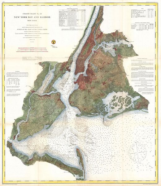
| Coast Chart No. 20, New York Bay and Harbor, New York. | |||
|---|---|---|---|
| Artist | |||
| Title |
Coast Chart No. 20, New York Bay and Harbor, New York. |
||
| Description |
English: A rare 1866 coastal chart of New York City, it’s harbor, and environs. One of the first 19th century carts to depicts New York City as we know it today, including Manhattan, Queens, Brooklyn, the Bronx and Staten Island. Also includes Jersey City, Newark and Hoboken. This is possibly the most advanced chart in this series with far more detail than previous editions. In addition to inland details, this chart contains a wealth of practical information for the mariner from oceanic depths, to harbors and navigation tips on important channels. Map also includes tables of light houses and beacons, tides and magnetic declination as well as detailed sailing instructions. The triangulation for this chart was prepared by J. Ferguson and E. Blunt. The topography by H. L. Whiting, S. A. Gilbert, A. M Harrison, F. W. Door, C. Rockwell and J. M E. Chan. The hydrography was accomplished by R. Wainwright and T. A. Craven. The entire production was supervised by A. D. Bache, Superintendent of the Survey of the Coast of the United States and one of the most influential American cartographers of the 19th century. |
||
| Date | 1866 (dated) | ||
| Dimensions | height: 31 in (78.7 cm); width: 27 in (68.5 cm) | ||
| Accession number |
Geographicus link: NewYorkCity3-uscs-1866 |
||
| Source/Photographer |
Report of the Superintendant of the United States Coast Survey, Washington, (1867 Supplement to the 1865 edition).
|
||
Licensing[edit]
This work is in the public domain in the United States because it was published (or registered with the U.S. Copyright Office) before January 1, 1929.
Public domain works must be out of copyright in both the United States and in the source country of the work in order to be hosted on the Commons. If the work is not a U.S. work, the file must have an additional copyright tag indicating the copyright status in the source country.
Note: This tag should not be used for sound recordings. |
File history
Click on a date/time to view the file as it appeared at that time.
| Date/Time | Thumbnail | Dimensions | User | Comment | |
|---|---|---|---|---|---|
| current | 16:33, 23 March 2011 | | 5,209 × 6,000 (7.11 MB) | BotMultichillT (talk | contribs) | {{subst:User:Multichill/Geographicus |link=http://www.geographicus.com/P/AntiqueMap/NewYorkCity3-uscs-1866 |product_name=1866 U.S. Coast Survey Nautical Chart of Map of New York City and Harbor |map_title=Coast Chart No. 20, New York Bay and Harbor, New Y |
You cannot overwrite this file.
File usage on Commons
The following 2 pages use this file:
File usage on other wikis
The following other wikis use this file:
- Usage on en.wikipedia.org
- Usage on zh.wikipedia.org