File:19940703diaoyutai.jpg
出典:ウィキメディア・コモンズ (Wikimedia Commons)
ナビゲーションに移動
検索に移動
19940703diaoyutai.jpg (707 × 446 ピクセル、ファイルサイズ: 12キロバイト、MIME タイプ: image/jpeg)
ファイル情報
構造化データ
キャプション
キャプション
このファイルの内容を1行で記述してください
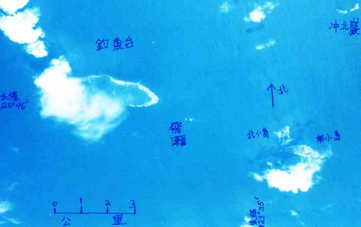
Diaoyutai Islands east of Taiwan, from the air
概要[編集]
| 解説19940703diaoyutai.jpg |
English: The Diaoyutai Islands are located 200 km ENE of Taipei, capitol of Taiwan. Diaoyutai means "fishing platform" in Chinese. I happened to take this a photo of Diaoyutai Is. 此釣魚台之空照為我攝。
We see light beaches and dark vegetation. 海灘白色,暗的是植物。 Elevations of highest points of islands 各島最高點:釣魚台 Diaoyutai 383 m, 北小島 Beixiaodao 135 m, Nanxiaodao 南小島 149 m, 沖北岩 Chongbeiyan 28 m。[Statistics from Taiwan Gov't 1:50000 topo maps. 為何北小島長得與經建版圖不一樣?] north is up; scale in km. Please turn this picture upside down for original from-plane viewing feeling; 若要原從飛機看感,相片請倒放 taken 3 July 1994. weiyun at mac.com said on Sep 11 2000:
|
| 日付 | UTC |
| 原典 | 投稿者自身による著作物 |
| 作者 | Jidanni |
| 被写体の位置 | 25° 44′ 41.49″ 北, 123° 28′ 26.9″ 東 | 以下のサービスでこの位置を確認する: オープンストリートマップ |
|---|
ライセンス[編集]
この作品の著作権者である私は、この作品を以下のライセンスで提供します。
このファイルはクリエイティブ・コモンズ 表示-継承 3.0 非移植ライセンスのもとに利用を許諾されています。
- あなたは以下の条件に従う場合に限り、自由に
- 共有 – 本作品を複製、頒布、展示、実演できます。
- 再構成 – 二次的著作物を作成できます。
- あなたの従うべき条件は以下の通りです。
- 表示 – あなたは適切なクレジットを表示し、ライセンスへのリンクを提供し、変更があったらその旨を示さなければなりません。これらは合理的であればどのような方法で行っても構いませんが、許諾者があなたやあなたの利用行為を支持していると示唆するような方法は除きます。
- 継承 – もしあなたがこの作品をリミックスしたり、改変したり、加工した場合には、あなたはあなたの貢献部分を元の作品とこれと同一または互換性があるライセンスの下に頒布しなければなりません。

|
この文書は、フリーソフトウェア財団発行のGNUフリー文書利用許諾書 (GNU Free Documentation License) 1.2またはそれ以降のバージョンの規約に基づき、複製や再配布、改変が許可されます。不可変更部分、表紙、背表紙はありません。このライセンスの複製は、GNUフリー文書利用許諾書という章に含まれています。http://www.gnu.org/copyleft/fdl.htmlGFDLGNU Free Documentation Licensetruetrue |
あなたは上記のライセンスから、どれか一つ以上を選択できます。
ファイルの履歴
過去の版のファイルを表示するには、その版の日時をクリックしてください。
| 日付と時刻 | サムネイル | 寸法 | 利用者 | コメント | |
|---|---|---|---|---|---|
| 現在の版 | 2009年9月6日 (日) 15:34 |  | 707 × 446 (12キロバイト) | Jidanni (トーク | 投稿記録) | {{Information |Description={{en|1=The Diaoyutai Islands are located 200 km ENE of Taibei, capitol of Taiwan. Diaoyutai means "fishing platform" in Chinese. I happened to take this a photo of Diaoyutai Is. [Photo: Diaoyutai Islands from plane. 釣魚台之 |
このファイルは上書きできません。
ファイルの使用状況
このファイルを使用しているページはありません。
メタデータ
このファイルには、追加情報があります (おそらく、作成やデジタル化する際に使用したデジタルカメラやスキャナーが追加したものです)。
このファイルが元の状態から変更されている場合、修正されたファイルを完全に反映していない項目がある場合があります。
| JPEGファイルのコメント | Created with The GIMP |
|---|
