File:2010-R07-GM-basisbeeld.jpg
Jump to navigation
Jump to search

Size of this preview: 638 × 600 pixels. Other resolutions: 255 × 240 pixels | 511 × 480 pixels | 702 × 660 pixels.
Original file (702 × 660 pixels, file size: 282 KB, MIME type: image/jpeg)
Captions
Captions
Add a one-line explanation of what this file represents
Summary[edit]
| Description |
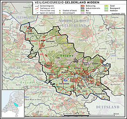
Nederlands: Veiligheidsregio Gelderland Midden, met indeling van gemeenten (2010) en impressie van het landschap.
Door Jan-Willem van Aalst, samengesteld uit publiek beschikbare geo-data:
|
| Date | |
| Source | Own work |
| Author | Janwillemvanaalst |
| Other versions | 2009-Basisbeeld-Regio07-Gelderland_midden.jpg |
Licensing[edit]
I, the copyright holder of this work, hereby publish it under the following license:
This file is licensed under the Creative Commons Attribution-Share Alike 3.0 Unported license.
- You are free:
- to share – to copy, distribute and transmit the work
- to remix – to adapt the work
- Under the following conditions:
- attribution – You must give appropriate credit, provide a link to the license, and indicate if changes were made. You may do so in any reasonable manner, but not in any way that suggests the licensor endorses you or your use.
- share alike – If you remix, transform, or build upon the material, you must distribute your contributions under the same or compatible license as the original.
File history
Click on a date/time to view the file as it appeared at that time.
| Date/Time | Thumbnail | Dimensions | User | Comment | |
|---|---|---|---|---|---|
| current | 13:56, 1 January 2010 | | 702 × 660 (282 KB) | Janwillemvanaalst (talk | contribs) | {{Information |Description={{nl|1=Veiligheidsregio Gelderland Midden, met indeling van gemeenten (2010) en impressie van het landschap. Door Jan-Willem van Aalst, samengesteld uit publiek beschikbare geo-data: * Referentie-ondergrond (kustlijn, steden, we |
You cannot overwrite this file.
File usage on Commons
There are no pages that use this file.