File:2017 Central Mexico earthquake map.svg

Original file (SVG file, nominally 428 × 426 pixels, file size: 935 KB)
Captions
Captions
Summary[edit]
| Description |
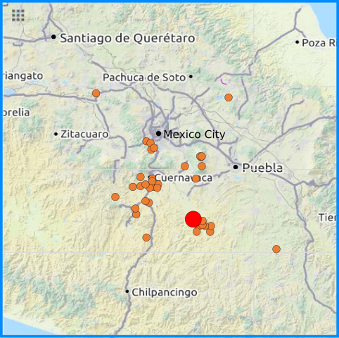
English: 2017 Central Mexico earthquake map as of 22 September. Red mark indicates the mainshock |
| Date | |
| Source |
Own work
|
| Author | Phoenix7777 |
Licensing[edit]
- You are free:
- to share – to copy, distribute and transmit the work
- to remix – to adapt the work
- Under the following conditions:
- attribution – You must give appropriate credit, provide a link to the license, and indicate if changes were made. You may do so in any reasonable manner, but not in any way that suggests the licensor endorses you or your use.
- share alike – If you remix, transform, or build upon the material, you must distribute your contributions under the same or compatible license as the original.
| Description |
English: 2017 Central Mexico earthquake map - SSN |
|||
| Date | ||||
| Source | openstreetmap.org | |||
| Creator |
Own work OpenStreetMap contributors |
|||
| Permission (Reusing this file) |
OpenStreetMap data is available under the Open Database License (details). Map tiles are licensed under the Creative Commons Attribution-ShareAlike 2.0 license (CC-BY-SA 2.0).
This file is licensed under the Creative Commons Attribution-Share Alike 2.0 Generic license.
|
|||
| Georeferencing | If inappropriate please set warp_status = skip to hide. |
File history
Click on a date/time to view the file as it appeared at that time.
| Date/Time | Thumbnail | Dimensions | User | Comment | |
|---|---|---|---|---|---|
| current | 00:18, 24 September 2017 | | 428 × 426 (935 KB) | Phoenix7777 (talk | contribs) | Color changed |
| 23:49, 23 September 2017 |  | 432 × 427 (930 KB) | Phoenix7777 (talk | contribs) | User created page with UploadWizard |
You cannot overwrite this file.
File usage on Commons
There are no pages that use this file.
File usage on other wikis
The following other wikis use this file:
- Usage on en.wikipedia.org
- Usage on es.wikipedia.org
- Usage on id.wikipedia.org
- Usage on uk.wikipedia.org
- Usage on zh.wikipedia.org