File:3-4 VIEW, LOOKING SOUTHWEST, SHOWING WEST ELEVATION PARAPETS, ROADWAY AND PARTIAL EAST ELEVATION (SCALE ROD IS MEASURED IN FEET) - Edgemere Street Bridge, Spanning Lake No. 3 HAER ARK,60-NOLI,3-2.tif
Jump to navigation
Jump to search

Size of this JPG preview of this TIF file: 753 × 600 pixels. Other resolutions: 302 × 240 pixels | 603 × 480 pixels | 965 × 768 pixels | 1,280 × 1,019 pixels | 2,560 × 2,038 pixels | 5,000 × 3,981 pixels.
Original file (5,000 × 3,981 pixels, file size: 18.99 MB, MIME type: image/tiff)
Captions
Captions
Add a one-line explanation of what this file represents
Summary[edit]
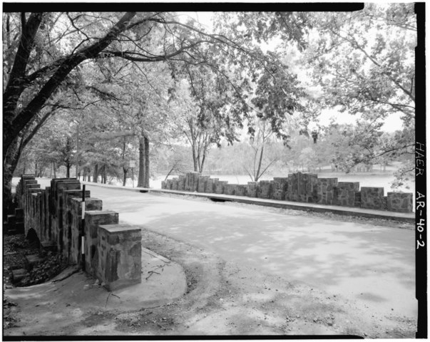
| 3-4 VIEW, LOOKING SOUTHWEST, SHOWING WEST ELEVATION PARAPETS, ROADWAY AND PARTIAL EAST ELEVATION (SCALE ROD IS MEASURED IN FEET) - Edgemere Street Bridge, Spanning Lake No. 3 adjacent branch at Edgemere Street, North Little Rock, Pulaski County, AR | ||||
|---|---|---|---|---|
| Photographer |
Holder, Jeff Related names:
|
|||
| Title |
3-4 VIEW, LOOKING SOUTHWEST, SHOWING WEST ELEVATION PARAPETS, ROADWAY AND PARTIAL EAST ELEVATION (SCALE ROD IS MEASURED IN FEET) - Edgemere Street Bridge, Spanning Lake No. 3 adjacent branch at Edgemere Street, North Little Rock, Pulaski County, AR |
|||
| Depicted place | Arkansas; Pulaski County; North Little Rock | |||
| Date | 1988 | |||
| Dimensions | 4 x 5 in. | |||
| Current location |
Library of Congress Prints and Photographs Division Washington, D.C. 20540 USA http://hdl.loc.gov/loc.pnp/pp.print |
|||
| Accession number |
HAER ARK,60-NOLI,3-2 |
|||
| Credit line |
|
|||
| Notes |
|
|||
| References |
|
|||
| Source | https://www.loc.gov/pictures/item/ar0098.photos.010457p | |||
| Permission (Reusing this file) |
|
|||

| Object location | | View this and other nearby images on: OpenStreetMap |
|---|
File history
Click on a date/time to view the file as it appeared at that time.
| Date/Time | Thumbnail | Dimensions | User | Comment | |
|---|---|---|---|---|---|
| current | 12:29, 27 June 2014 |  | 5,000 × 3,981 (18.99 MB) | Fæ (talk | contribs) | GWToolset: Creating mediafile for Fæ. HABS batch upload 26 June 2014 (151:200) |
You cannot overwrite this file.
File usage on Commons
The following page uses this file: