File:8and-148; x 10and-148; black and white photographic print made from original 1934, 8and-148; x 10and-148; black and white photographic negative. New 4and-148; x 5and-148; archival HAER LA-17-138.tif
Jump to navigation
Jump to search
Size of this JPG preview of this TIF file: 745 × 600 pixels. Other resolutions: 298 × 240 pixels | 596 × 480 pixels | 954 × 768 pixels | 1,272 × 1,024 pixels | 2,544 × 2,048 pixels | 5,614 × 4,519 pixels.
Original file (5,614 × 4,519 pixels, file size: 24.2 MB, MIME type: image/tiff)
Captions
Captions
Add a one-line explanation of what this file represents
Summary[edit]
| Photographer |
Lamkin, Marcus |
|||
| Title |
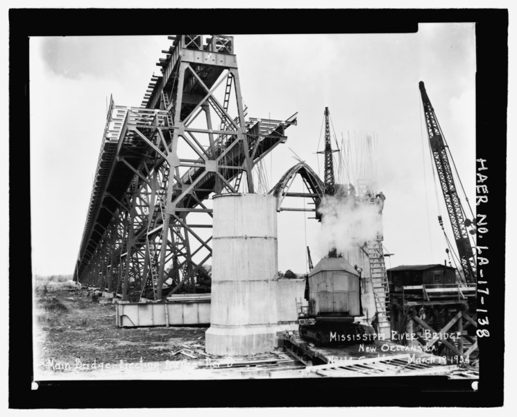
8and-148; x 10and-148; black and white photographic print made from original 1934, 8and-148; x 10and-148; black and white photographic negative. New 4and-148; x 5and-148; archival negative made from print. Original photographer unknown. Original 8and-148; x 10and-148; negative located in the files of the New Orleans Public Belt Railroad administrative offices at 5100 Jefferson Highway, Jefferson, LA 70123.; MARCH 19, 1934 PHOTOGRAPH NO. 134 OF CONTRACT NO. 3 SHOWING MAIN BRIDGE ERECTING FORMS PIER D. - Huey P. Long Bridge, Spanning Mississippi River approximately midway between nine and twelve mile points upstream from and west of New Orleans, Jefferson, Jefferson Parish, LA |
|||
| Description |
Modjeski, Masters and Chase, Inc., engineer; Siems-Helmers, Inc., builder; American Bridge Company, builder; McDonald Engineering Company, builder; McClintic-Marshall Corporation, builder; Paul M. Brignac Electric and Machine Company, builder; Jack Harris and National Construction Company, builder; Calloway, Deborah, transmitter; Coco and Company, contractor |
|||
| Depicted place | Louisiana; Jefferson Parish; Jefferson | |||
| Date | Documentation compiled after 1968; 2005 | |||
| Dimensions | 4 x 5 in. | |||
| Current location |
Library of Congress Prints and Photographs Division Washington, D.C. 20540 USA http://hdl.loc.gov/loc.pnp/pp.print |
|||
| Accession number |
HAER LA-17-138 |
|||
| Credit line |
|
|||
| Notes |
|
|||
| Source | https://www.loc.gov/pictures/item/la0507.photos.221303p | |||
| Permission (Reusing this file) |
|

| Object location | | View this and other nearby images on: OpenStreetMap |
|---|
File history
Click on a date/time to view the file as it appeared at that time.
| Date/Time | Thumbnail | Dimensions | User | Comment | |
|---|---|---|---|---|---|
| current | 05:36, 18 July 2014 |  | 5,614 × 4,519 (24.2 MB) | Fæ (talk | contribs) | GWToolset: Creating mediafile for Fæ. HABS 17 July 2014 (1401:1600) |
You cannot overwrite this file.
File usage on Commons
The following page uses this file: