File:A719 in 2015 map-fr.svg
Jump to navigation
Jump to search

Size of this PNG preview of this SVG file: 800 × 272 pixels. Other resolutions: 320 × 109 pixels | 640 × 217 pixels | 1,024 × 348 pixels | 1,280 × 435 pixels | 2,560 × 869 pixels | 3,346 × 1,136 pixels.
Original file (SVG file, nominally 3,346 × 1,136 pixels, file size: 63 KB)
Captions
Captions
Add a one-line explanation of what this file represents
| Description |
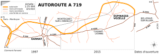
English: Map of A719 autoroute from Gannat to Espinasse-Vozelle, Allier, France
Français : Carte de l'autoroute A719 reliant Gannat à Espinasse-Vozelle, Allier, France |
|||
| Date | ||||
| Source | Derived work from OpenStreetMap data | |||
| Author | OpenStreetMap contributors, adapted by Tabl-trai | |||
| Permission (Reusing this file) |
This file is licensed under the Creative Commons Attribution-Share Alike 2.0 Generic license.
|
File history
Click on a date/time to view the file as it appeared at that time.
| Date/Time | Thumbnail | Dimensions | User | Comment | |
|---|---|---|---|---|---|
| current | 15:25, 30 January 2015 | 3,346 × 1,136 (63 KB) | Tabl-trai (talk | contribs) | {{Information |Description ={{en|1=Map of A719 autoroute from Gannat to Espinasse-Vozelle, Allier, France}} {{fr|1=Carte de l'autoroute A719 reliant Gannat à Espinasse-Vozelle, Allier, France}} |Source =Derived work from OpenStreetMap data... |
You cannot overwrite this file.
File usage on Commons
The following page uses this file:
File usage on other wikis
The following other wikis use this file:
- Usage on fr.wikipedia.org