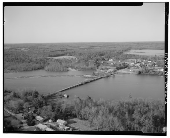
File:AERIAL VIEW, VIEW WEST SHOWING TOWN OF WALKERTON BEYOND - Walkerton Bridge, Spanning Mattaponi River at State Route 629, Walkerton, King and Queen County, VA HAER VA,49-WALKT.V,1-2.tif
Jump to navigation
Jump to search

Size of this JPG preview of this TIF file: 734 × 599 pixels. Other resolutions: 294 × 240 pixels | 588 × 480 pixels | 941 × 768 pixels | 1,254 × 1,024 pixels | 2,508 × 2,048 pixels | 5,000 × 4,083 pixels.
Original file (5,000 × 4,083 pixels, file size: 19.47 MB, MIME type: image/tiff)
Captions
Captions
Add a one-line explanation of what this file represents
Summary[edit]
| AERIAL VIEW, VIEW WEST SHOWING TOWN OF WALKERTON BEYOND - Walkerton Bridge, Spanning Mattaponi River at State Route 629, Walkerton, King and Queen County, VA | ||||
|---|---|---|---|---|
| Title |
AERIAL VIEW, VIEW WEST SHOWING TOWN OF WALKERTON BEYOND - Walkerton Bridge, Spanning Mattaponi River at State Route 629, Walkerton, King and Queen County, VA |
|||
| Depicted place | Virginia; King and Queen County; Walkerton | |||
| Date | Documentation compiled after 1968 | |||
| Dimensions | 4 x 5 in. | |||
| Current location |
Library of Congress Prints and Photographs Division Washington, D.C. 20540 USA http://hdl.loc.gov/loc.pnp/pp.print |
|||
| Accession number |
HAER VA,49-WALKT.V,1-2 |
|||
| Credit line |
|
|||
| Notes |
|
|||
| Source | https://www.loc.gov/pictures/item/va1618.photos.368284p | |||
| Permission (Reusing this file) |
|
|||

File history
Click on a date/time to view the file as it appeared at that time.
| Date/Time | Thumbnail | Dimensions | User | Comment | |
|---|---|---|---|---|---|
| current | 10:41, 4 August 2014 |  | 5,000 × 4,083 (19.47 MB) | Fæ (talk | contribs) | GWToolset: Creating mediafile for Fæ. HABS 2014-08-02 (3401:3600) |
You cannot overwrite this file.
File usage on Commons
The following page uses this file: