File:AMH-4652-NA Map of Edam island near Batavia.jpg
Original file (2,400 × 1,132 pixels, file size: 440 KB, MIME type: image/jpeg)
Captions
Captions
Summary[edit]
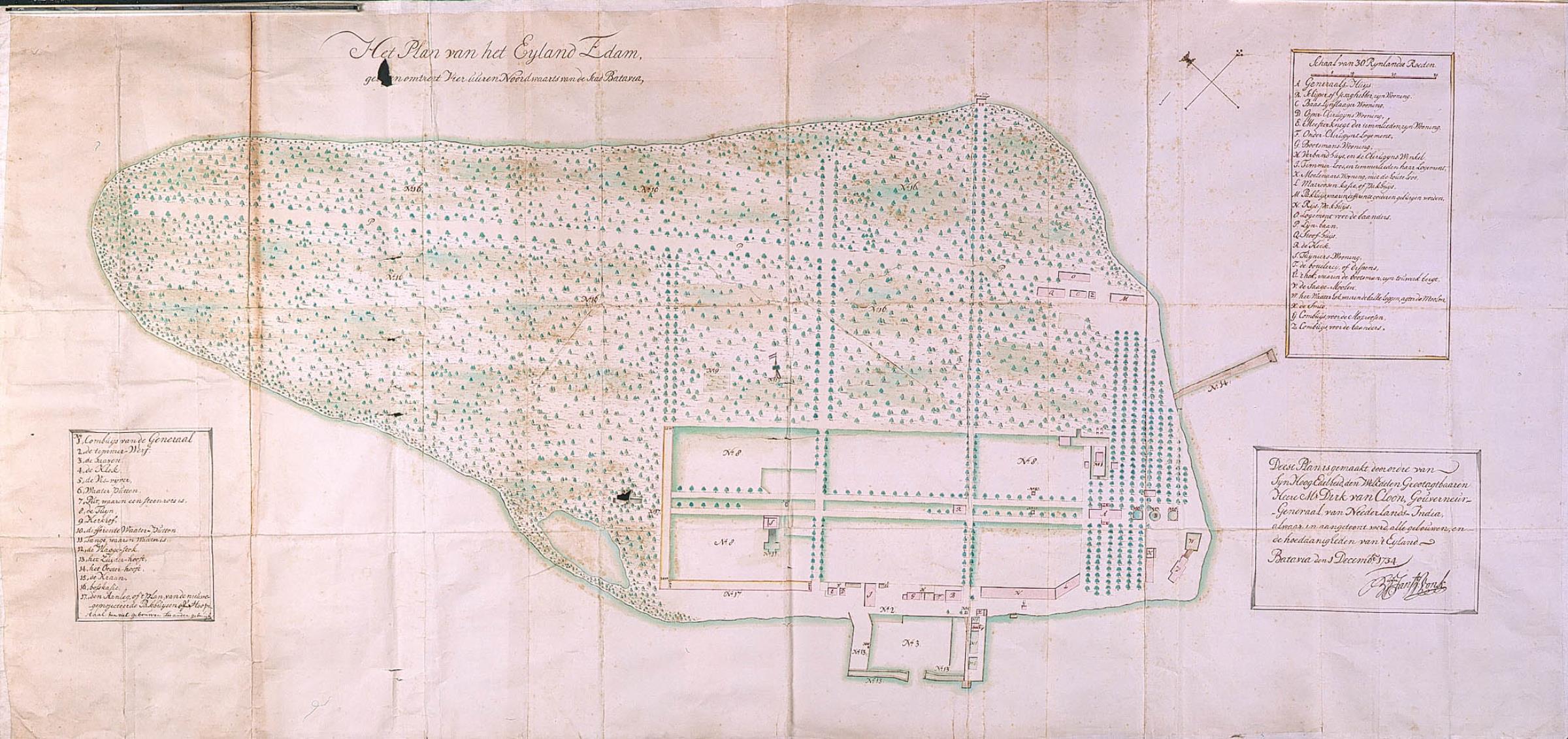
Nederlands: Plattegrond van het eiland Edam bij Batavia
                     English:  Map of Edam island near Batavia
                     Bahasa Indonesia:  Peta Pulau Edam di dekat Batavia
( |
||||||||||||||||||||||||
|---|---|---|---|---|---|---|---|---|---|---|---|---|---|---|---|---|---|---|---|---|---|---|---|---|
| Author |
Creator:Boudewijn Jansz Vonk Creator:G.G. Dirk van Cloon Nederlands: Boudewijn Jansz Vonk (landmeter / kaartenmaker), G.G. Dirk van Cloon (opdrachtgever)
English: Boudewijn Jansz Vonk (land surveyor / mapmaker), G.G. Dirk van Cloon (patron) |
|||||||||||||||||||||||
| Title |
Nederlands: Plattegrond van het eiland Edam bij Batavia
English: Map of Edam island near Batavia
Bahasa Indonesia: Peta Pulau Edam di dekat Batavia |
|||||||||||||||||||||||
| Description |
Nederlands: Titel catalogus Leupe (NA): Het Plan van het Eyland Edam, gelegen omtrent vier uuren Noordwaarts van de stad Batavia.
Legenda: A-Z; 1-17 De randen en naden zijn ter versterking met stroken beplakt, maar in de kaart zitten wel verschillende gaten. Notities verso: Behoort by de overgekomen Brieven en papieren van Batavia 1735 4 deel [de vijf van het jaar is onduidelijk, maar gezien de datering wel waarschijnlijk] / 1950 [moet het folionummer in de band OBP zijn] / No. 30 [waarschijnlijk het volgnummer van het stuk in de band OBP] / 624 b.English: According to the Leupe catalogue (NA), the original title reads: Het Plan van het Eyland Edam, gelegen omtrent vier uuren Noordwaarts van de stad Batavia.
Key: A-Z; 1-17 The edges and folds have been reinforced with strips of paper, but the chart has several holes. Notes on reverse: Behoort by de overgekomen Brieven en papieren van Batavia 1735 4 deel [the number 5 in the year is unclear, but given the date this is the most likely] / 1950 [should be the folio number in the OBP volume] / No. 30 [probably the number of the item in the OBP volume] / 624 b.Bahasa Indonesia: Menurut katalog Leupe (NA), judul aslinya berbunyi: Het Plan van het Eyland Edam, gelegen omtrent vier uuren Noordwaarts van de stad Batavia.
Kunci: A-Z; 1-17 Tepi dan lipatan telah diperkuat dengan potongan kertas, tetapi kertas ini memiliki beberapa lubang. Catatan di belakang: Behoort by de overgekomen Brieven en papieren van Batavia 1735 4 deel [angka 5 pada tahun itu tidak jelas, tetapi sepertinya adalah tanggal] / 1950 [seharusnya nomor folio dalam volume OBP] / No. 30 [mungkin jumlah item dalam volume OBP] / 624 b. |
|||||||||||||||||||||||
| Date | 1734 | |||||||||||||||||||||||
| Medium |
Nederlands: ingekleurde tekening op papier
English: coloured drawing on paper
Bahasa Indonesia: gambar berwarna di atas kertas |
|||||||||||||||||||||||
| Dimensions | height: 159 cm (62.5 in); width: 76.5 cm (30.1 in) | |||||||||||||||||||||||
| Collection |
|
|||||||||||||||||||||||
| Accession number |
NL-HaNA_4.VEL_1249 (old number: VEL1249) |
|||||||||||||||||||||||
| Inscriptions |
Het Plan van het Eyland Edam
author: B. Jansz. Vonk |
|||||||||||||||||||||||
| Notes |
English: Subjects: key, chart / map / plan
Nederlands: Onderwerpen: legenda, plattegrond / kaart |
|||||||||||||||||||||||
| Source/Photographer |
|
|||||||||||||||||||||||
| Permission (Reusing this file) |
|
|||||||||||||||||||||||

File history
Click on a date/time to view the file as it appeared at that time.
| Date/Time | Thumbnail | Dimensions | User | Comment | |
|---|---|---|---|---|---|
| current | 16:54, 10 June 2014 | | 2,400 × 1,132 (440 KB) | HuskyBot (talk | contribs) | == {{int:filedesc}} == {{Artwork |title = {{nl|1=Plattegrond van het eiland Edam bij Batavia}} {{en|1=Map of Edam island near Batavia}} |description = {{nl|1=Titel catalogus Leupe (NA): ''Het Plan van het Eylan... |
You cannot overwrite this file.
File usage on Commons
The following page uses this file: