File:AMH-7015-KB View of Batavia.jpg
Original file (2,400 × 2,031 pixels, file size: 1.33 MB, MIME type: image/jpeg)
Captions
Captions
Summary[edit]
Nederlands: Gezicht op Batavia
English: View of Batavia( |
|||||||||||||||||||||
|---|---|---|---|---|---|---|---|---|---|---|---|---|---|---|---|---|---|---|---|---|---|
| Author |
Creator:I. M. Seeligmann Creator:Johann Carl Tetschner Nederlands: Johann Wolfgang Heydt (tekenaar), I. M. Seeligmann (graveur / etser), Johann Carl Tetschner (uitgever)
English: Johann Wolfgang Heydt (draughtsman), I. M. Seeligmann (engraver / etcher), Johann Carl Tetschner (publisher) |
||||||||||||||||||||
| Title |
Nederlands: Gezicht op Batavia
English: View of Batavia |
||||||||||||||||||||
| Description |
Nederlands: Gezicht op Batavia, in spiegelbeeld weergegeven.
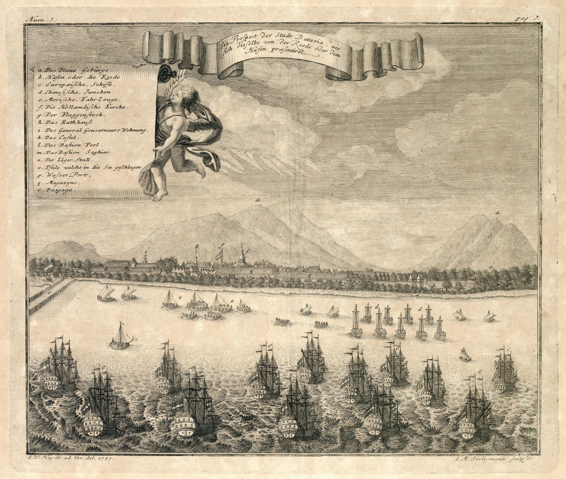
Ein Prospect der Stadt Batavia, wie sich dieselbe von der Reede oder dem Hafen praesentiret. Legenda: a. Das Blaue Gebirge / b. Hafen oder die Reede. / c. Europaeische-Schiffe. / e. Morische-Fahr Zeuge. / f. Die Hollaendische Kirche. / g. Der Flaggenstock. / h. Das Rathhauß / i. Des General Gouverneurs Wohnung. / k. Das Castel. / l. Das Bastion Perl. / m. Das Bastion Saphier. / n. Der Läger-Stall. / o. Pfale welche in die See geschlagen / p. Wasser-Port. / q. Magazyns. / r. Busgage.. Linksboven: Num :I:.English: View of Batavia, rendered as a mirror image.
Ein Prospect der Stadt Batavia, wie sich dieselbe von der Reede oder dem Hafen praesentiret. Key: a. Das Blaue Gebirge / b. Hafen oder die Reede. / c. Europaeische-Schiffe. / e. Morische-Fahr Zeuge. / f. Die Hollaendische Kirche. / g. Der Flaggenstock. / h. Das Rathhauß / i. Des General Gouverneurs Wohnung. / k. Das Castel. / l. Das Bastion Perl. / m. Das Bastion Saphier. / n. Der Läger-Stall. / o. Pfale welche in die See geschlagen / p. Wasser-Port. / q. Magazyns. / r. Busgage.. Top left: Num :I:. |
||||||||||||||||||||
| Date | 1737 | ||||||||||||||||||||
| Medium |
Nederlands: koperdruk op papier
English: copperplate printing on paper |
||||||||||||||||||||
| Dimensions | height: 29 cm (11.4 in); width: 25.5 cm (10 in) | ||||||||||||||||||||
| Collection |
|
||||||||||||||||||||
| Accession number |
2102 A 7 p. 1 |
||||||||||||||||||||
| Inscriptions |
Ein Prospect der Stadt Batavia, wie sich dieselbe von der Reede oder dem Hafen praesentiret
author: I.W. Heydt ad Viv. del. 1737 / I.M. Seeligmann sculpsit |
||||||||||||||||||||
| Notes |
English: Subjects: survey / view, banderole / cartouche / ornamentation, key, ship / vessel, building, anchorage / pier / harbour, church / parsonage, fortification, government building / residence, assembly hall / town hall, gate
Nederlands: Onderwerpen: overzicht / aanzicht, banderol / cartouche / versiering, legenda, schip / vaartuig, gebouw, rede / haven / pier, kerk / pastorie, vesting, gouvernementshuis / -gebouw, raadhuis / stadhuis, poort
English: Post: this image is related to a VOC trading post called Jakarta |
||||||||||||||||||||
| Source/Photographer |
|
||||||||||||||||||||
| Permission (Reusing this file) |
|
||||||||||||||||||||

| Object location | | View this and other nearby images on: OpenStreetMap |
|---|
File history
Click on a date/time to view the file as it appeared at that time.
| Date/Time | Thumbnail | Dimensions | User | Comment | |
|---|---|---|---|---|---|
| current | 12:09, 10 June 2014 | | 2,400 × 2,031 (1.33 MB) | HuskyBot (talk | contribs) | == {{int:filedesc}} == {{Artwork |title = {{nl|1=Gezicht op Batavia}} {{en|1=View of Batavia}} |description = {{nl|1=Gezicht op Batavia, in spiegelbeeld weergegeven. ''Ein Prospect der Stadt Batavia, wie sich... |
You cannot overwrite this file.
File usage on Commons
The following page uses this file: