File:A Journey in Khorassan (1890) fold out map.jpg
Jump to navigation
Jump to search

Size of this preview: 800 × 395 pixels. Other resolutions: 320 × 158 pixels | 640 × 316 pixels | 1,024 × 505 pixels | 1,280 × 632 pixels | 2,560 × 1,263 pixels | 4,507 × 2,224 pixels.
Original file (4,507 × 2,224 pixels, file size: 962 KB, MIME type: image/jpeg)
Captions
Captions
Add a one-line explanation of what this file represents
Summary[edit]
_fold_out_map.jpg&action=edit§ion=1)
| Description |
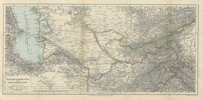
English: Fold out map entitled "Russian Central Asia and the Transcaspian Railway" included at the end of the book A Journey in Khorassan and Central Asia (1890). Map attributed to the Proceedings of the Royal Geographical Society, 1889. |
| Date | |
| Source | File:Kennedy, Robert John - A Journey in Khorassan (1890).pdf |
| Author | F. S. Meller, Red Lion Square |
Licensing[edit]
_fold_out_map.jpg&action=edit§ion=2)
This media file is in the public domain in the United States. This applies to U.S. works where the copyright has expired, often because its first publication occurred prior to January 1, 1929, and if not then due to lack of notice or renewal. See this page for further explanation.
|
 | |
 |
This image might not be in the public domain outside of the United States; this especially applies in the countries and areas that do not apply the rule of the shorter term for US works, such as Canada, Mainland China (not Hong Kong or Macao), Germany, Mexico, and Switzerland. The creator and year of publication are essential information and must be provided. See Wikipedia:Public domain and Wikipedia:Copyrights for more details.
|
File history
Click on a date/time to view the file as it appeared at that time.
| Date/Time | Thumbnail | Dimensions | User | Comment | |
|---|---|---|---|---|---|
| current | 19:43, 16 November 2012 | | 4,507 × 2,224 (962 KB) | AdamBMorgan (talk | contribs) | User created page with UploadWizard |
You cannot overwrite this file.
File usage on Commons
The following 2 pages use this file:
File usage on other wikis
The following other wikis use this file:
- Usage on en.wikisource.org
- Usage on ko.wikipedia.org
_fold_out_map.jpg&oldid=801006535)