File:A map of the country in which the army under Lt. General Burgoyne acted in the campaign of 1777 - shewing the marches of the army and the places of the principal actions - drawn by Mr. Medcalfe and NYPL433999.tiff
Jump to navigation
Jump to search

Size of this JPG preview of this TIF file: 343 × 598 pixels. Other resolutions: 137 × 240 pixels | 275 × 480 pixels | 440 × 768 pixels | 587 × 1,024 pixels | 1,174 × 2,048 pixels | 2,816 × 4,913 pixels.
Original file (2,816 × 4,913 pixels, file size: 39.59 MB, MIME type: image/tiff)
Captions
Captions
Add a one-line explanation of what this file represents
Summary[edit]
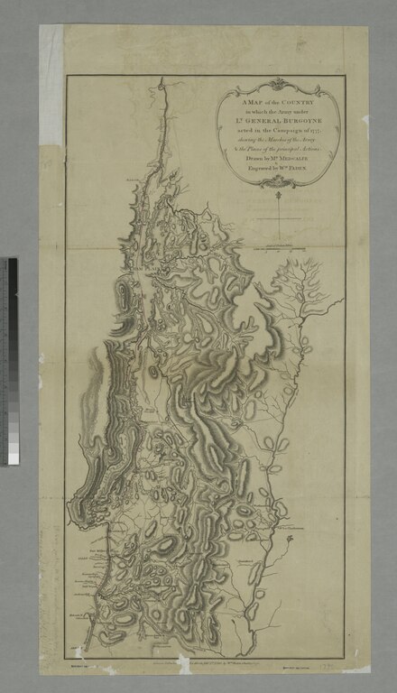
| Description | A map of the country in which the army under Lt. General Burgoyne acted in the campaign of 1777 : shewing the marches of the army and the places of the principal actions / drawn by Mr. Medcalfe and engraved by Wm. Faden.; Maps of North America. / Countries / United States (except New York) / Revolutionary War, 1775-1783 | |||||||||||||||||||||||
| Notes | Covers the area from Champlain Lake Region to Albany, N.Y., and from Hudson River to the Connecticut River. ''Note 2.'') National Endowment for the Humanities Grant for Access to Early Maps of the Middle Atlantic Seaboard. ''Note 3.'') Relief shown by hachures. ''Note 4.'') Shows the route of the marches of the army in red ink. | |||||||||||||||||||||||
| Catalogue call number | Map Div. 01-475 [Filed with N.Y.S. Revol. War maps, Champlain, 1777] | |||||||||||||||||||||||
| Standard reference | LC Maps of North America, 1750-1789, 1183 | |||||||||||||||||||||||
| Date | Feby. 1st, 1780 | |||||||||||||||||||||||
| Source |
http://digitalgallery.nypl.org/nypldigital/dgkeysearchdetail.cfm?imageID=433999
|
|||||||||||||||||||||||
| Author | Medcalfe, Mr. -- Cartographer; Faden, William, 1750?-1836 -- Engraver | |||||||||||||||||||||||
| Permission (Reusing this file) |
From The Lionel Pincus and Princess Firyal Map Division. http://maps.nypl.org
|
|||||||||||||||||||||||
| Location | Stephen A. Schwarzman Building / The Lionel Pincus and Princess Firyal Map Division | |||||||||||||||||||||||
| Digital item published | 10-14-2005; updated 3-25-2011 | |||||||||||||||||||||||
| Digital ID | 433999 | |||||||||||||||||||||||

The making of this file was supported by Wikimedia UK.
To see other files made with the support of Wikimedia UK, please see the category Supported by Wikimedia UK.
|
File history
Click on a date/time to view the file as it appeared at that time.
| Date/Time | Thumbnail | Dimensions | User | Comment | |
|---|---|---|---|---|---|
| current | 10:41, 20 April 2014 |  | 2,816 × 4,913 (39.59 MB) | Fæ (talk | contribs) | GWToolset:: Creating mediafile for Fæ. Tranche 2.590 |
You cannot overwrite this file.
File usage on Commons
The following page uses this file: