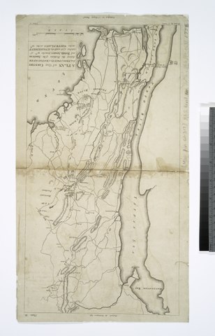
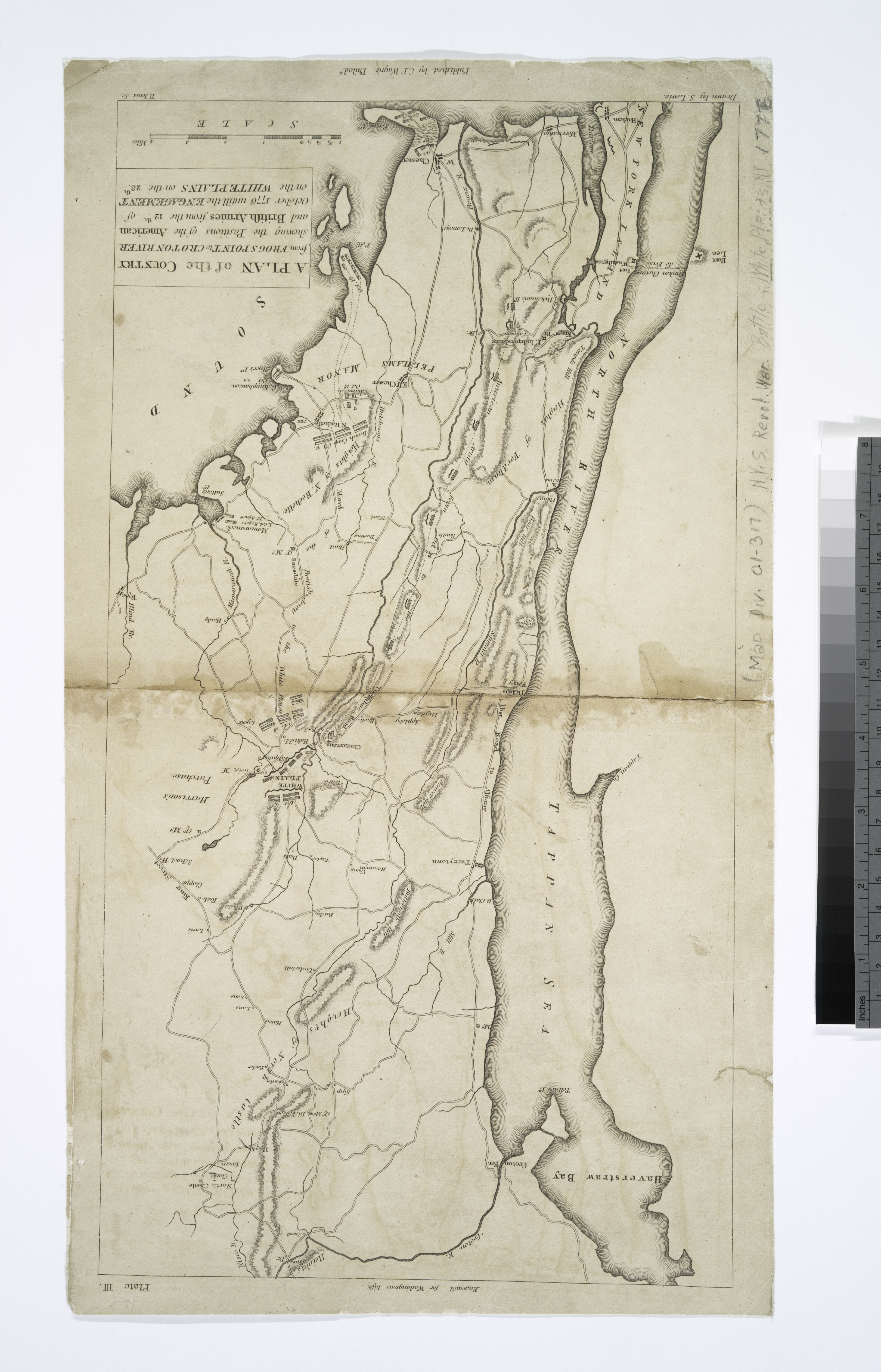
File:A plan of the country from Frogs Point to Croton River - shewing the positions of the American and British armies from the 12th of October 1776 until the engagement on the White Plains on the 28th - NYPL433992.tiff
Jump to navigation
Jump to search

Size of this JPG preview of this TIF file: 385 × 600 pixels. Other resolutions: 154 × 240 pixels | 308 × 480 pixels | 493 × 768 pixels | 657 × 1,024 pixels | 1,315 × 2,048 pixels | 3,808 × 5,931 pixels.
Original file (3,808 × 5,931 pixels, file size: 64.62 MB, MIME type: image/tiff)
Captions
Captions
Add a one-line explanation of what this file represents
Summary[edit]
| Description | A plan of the country from Frogs Point to Croton River : shewing the positions of the American and British armies from the 12th of October 1776 until the engagement on the White Plains on the 28th / drawn by S. Lewis ; B. Jones, sc. | |||||||||||||||||||||||
| Notes | Appears in John Marshall's The life of George Washington, 1807. Note 2.) In central upper margin: Engrav'd for Washington's Life. Note 3.) In upper right corner: Plate III. Note 4.) National Endowment for the Humanities Grant for Access to Early Maps of the Middle Atlantic Seaboard. Note 5.) Relief shown by hachures. | |||||||||||||||||||||||
| Standard reference | Phillips. Maps of America, p. 503, 504 | |||||||||||||||||||||||
| Physical description | 1 map ; 41 x 22 cm. | |||||||||||||||||||||||
| Catalog Call Number | Map Div. 01-317 [Filed with N.Y.S. Revol. War, White Plains. 1776] | |||||||||||||||||||||||
| Date | ||||||||||||||||||||||||
| Source |
http://digitalgallery.nypl.org/nypldigital/dgkeysearchdetail.cfm?imageID=433992
|
|||||||||||||||||||||||
| Author | Jones, Benjamin, fl. 1798-1815 -- Engraver ;Lewis, Samuel, 1753 or 4-1822 -- CartographerWayne, Caleb Parry, 1776-1849 -- Publisher | |||||||||||||||||||||||
| Permission (Reusing this file) |
From The Lionel Pincus & Princess Firyal Map Division. Released on a CC0 license.[1] | |||||||||||||||||||||||
| Digital ID | 433992 | |||||||||||||||||||||||
| Location | Stephen A. Schwarzman Building / The Lionel Pincus and Princess Firyal Map Division | |||||||||||||||||||||||
| NYPL digital item published | 2-3-2004; updated 3-25-2011 | |||||||||||||||||||||||

Licensing[edit]
| This file is made available under the Creative Commons CC0 1.0 Universal Public Domain Dedication. | |
| The person who associated a work with this deed has dedicated the work to the public domain by waiving all of their rights to the work worldwide under copyright law, including all related and neighboring rights, to the extent allowed by law. You can copy, modify, distribute and perform the work, even for commercial purposes, all without asking permission.
|
The making of this file was supported by Wikimedia UK.
To see other files made with the support of Wikimedia UK, please see the category Supported by Wikimedia UK.
|
File history
Click on a date/time to view the file as it appeared at that time.
| Date/Time | Thumbnail | Dimensions | User | Comment | |
|---|---|---|---|---|---|
| current | 18:20, 9 April 2014 |  | 3,808 × 5,931 (64.62 MB) | Fæ (talk | contribs) | =={{int:filedesc}}== {{NYPL_map |digital_id = 433992 |creators = Jones, Benjamin, fl. 1798-1815 -- Engraver ;Lewis, Samuel, 1753 or 4-1822 -- Cartographer |record_id = 252845 |catalog_call_number = Map Div. 01-317 [Filed with N.Y.S. Revol. War, White... |
You cannot overwrite this file.
File usage on Commons
There are no pages that use this file.