File:Abner Cloud House, Intersection of Canal Road and Reservoir Road Northwest, Washington, District of Columbia, DC HABS DC,WASH,167- (sheet 5 of 9).png

Original file (9,634 × 7,616 pixels, file size: 1.57 MB, MIME type: image/png)
Captions
Captions
| This image is a JPEG version of the original TIF image at File: Abner Cloud House, Intersection of Canal Road and Reservoir Road Northwest, Washington, District of Columbia, DC HABS DC,WASH,167- (sheet 5 of 9).tif.
However, any edits to the image should be based on the original TIF version in order to prevent generation loss, and both versions should be updated. Do not make edits based on this version. |
Summary[edit]
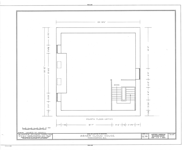
| HABS DC,WASH,167- (sheet 5 of 9) - Abner Cloud House, Intersection of Canal Road and Reservoir Road Northwest, Washington, District of Columbia, DC | ||||
|---|---|---|---|---|
| Title |
HABS DC,WASH,167- (sheet 5 of 9) - Abner Cloud House, Intersection of Canal Road and Reservoir Road Northwest, Washington, District of Columbia, DC |
|||
| Depicted place | District of Columbia; District of Columbia; Washington | |||
| Date | Documentation compiled after 1933 | |||
| Dimensions | 19 x 24 in. (B size) | |||
| Current location |
Library of Congress Prints and Photographs Division Washington, D.C. 20540 USA http://hdl.loc.gov/loc.pnp/pp.print |
|||
| Accession number |
HABS DC,WASH,167- (sheet 5 of 9) |
|||
| Credit line |
|
|||
| Notes |
The Abner Cloud house was built in about 1891 as the residence of a second generation miller. Cloud, who had his mill a few hundred yards west of the Maddox Branch, on the Potomac River side of the Chesapeake and Ohio Canal, was the son of a Chester County Pennsylvania miller. The mill was used as late as 1869 by D. L. Shoemaker.
|
|||
| Source | https://www.loc.gov/pictures/item/dc0057.sheet.00005a | |||
| Permission (Reusing this file) |
|
|||
| Other versions |
.png) .png) .png) .png) .png) .png) .png) .png) .png) .png) .png) .png) .png) .png) .png) .png) .png) .png) .png) .png) .png) |
|||

.png&action=edit§ion=1)
| Object location | | View this and other nearby images on: OpenStreetMap |
|---|
.png¶ms=038.895000_N_-077.036670_E_globe:Earth_class:object_type:object__&language=en)
File history
Click on a date/time to view the file as it appeared at that time.
| Date/Time | Thumbnail | Dimensions | User | Comment | |
|---|---|---|---|---|---|
| current | 14:30, 28 July 2014 | | 9,634 × 7,616 (1.57 MB) | Fæ (talk | contribs) | {{Compressed version|file=File:Abner_Cloud_House,_Intersection_of_Canal_Road_and_Reservoir_Road_Northwest,_Washington,_District_of_Columbia,_DC_HABS_DC,WASH,167-_(sheet_5_of_9).tif|thumb=nothumb}} =={{int:filedesc}}== {{Photograph | accession number... |
You cannot overwrite this file.
File usage on Commons
The following 44 pages use this file:
- File:Abner Cloud House, Intersection of Canal Road and Reservoir Road Northwest, Washington, District of Columbia, DC HABS DC,WASH,167- (sheet 10 of 13).png
- File:Abner Cloud House, Intersection of Canal Road and Reservoir Road Northwest, Washington, District of Columbia, DC HABS DC,WASH,167- (sheet 10 of 13).tif
- File:Abner Cloud House, Intersection of Canal Road and Reservoir Road Northwest, Washington, District of Columbia, DC HABS DC,WASH,167- (sheet 11 of 13).png
- File:Abner Cloud House, Intersection of Canal Road and Reservoir Road Northwest, Washington, District of Columbia, DC HABS DC,WASH,167- (sheet 11 of 13).tif
- File:Abner Cloud House, Intersection of Canal Road and Reservoir Road Northwest, Washington, District of Columbia, DC HABS DC,WASH,167- (sheet 12 of 13).png
- File:Abner Cloud House, Intersection of Canal Road and Reservoir Road Northwest, Washington, District of Columbia, DC HABS DC,WASH,167- (sheet 12 of 13).tif
- File:Abner Cloud House, Intersection of Canal Road and Reservoir Road Northwest, Washington, District of Columbia, DC HABS DC,WASH,167- (sheet 13 of 13).png
- File:Abner Cloud House, Intersection of Canal Road and Reservoir Road Northwest, Washington, District of Columbia, DC HABS DC,WASH,167- (sheet 13 of 13).tif
- File:Abner Cloud House, Intersection of Canal Road and Reservoir Road Northwest, Washington, District of Columbia, DC HABS DC,WASH,167- (sheet 1 of 13).png
- File:Abner Cloud House, Intersection of Canal Road and Reservoir Road Northwest, Washington, District of Columbia, DC HABS DC,WASH,167- (sheet 1 of 13).tif
- File:Abner Cloud House, Intersection of Canal Road and Reservoir Road Northwest, Washington, District of Columbia, DC HABS DC,WASH,167- (sheet 1 of 9).png
- File:Abner Cloud House, Intersection of Canal Road and Reservoir Road Northwest, Washington, District of Columbia, DC HABS DC,WASH,167- (sheet 1 of 9).tif
- File:Abner Cloud House, Intersection of Canal Road and Reservoir Road Northwest, Washington, District of Columbia, DC HABS DC,WASH,167- (sheet 2 of 13).png
- File:Abner Cloud House, Intersection of Canal Road and Reservoir Road Northwest, Washington, District of Columbia, DC HABS DC,WASH,167- (sheet 2 of 13).tif
- File:Abner Cloud House, Intersection of Canal Road and Reservoir Road Northwest, Washington, District of Columbia, DC HABS DC,WASH,167- (sheet 2 of 9).png
- File:Abner Cloud House, Intersection of Canal Road and Reservoir Road Northwest, Washington, District of Columbia, DC HABS DC,WASH,167- (sheet 2 of 9).tif
- File:Abner Cloud House, Intersection of Canal Road and Reservoir Road Northwest, Washington, District of Columbia, DC HABS DC,WASH,167- (sheet 3 of 13).png
- File:Abner Cloud House, Intersection of Canal Road and Reservoir Road Northwest, Washington, District of Columbia, DC HABS DC,WASH,167- (sheet 3 of 13).tif
- File:Abner Cloud House, Intersection of Canal Road and Reservoir Road Northwest, Washington, District of Columbia, DC HABS DC,WASH,167- (sheet 3 of 9).png
- File:Abner Cloud House, Intersection of Canal Road and Reservoir Road Northwest, Washington, District of Columbia, DC HABS DC,WASH,167- (sheet 3 of 9).tif
- File:Abner Cloud House, Intersection of Canal Road and Reservoir Road Northwest, Washington, District of Columbia, DC HABS DC,WASH,167- (sheet 4 of 13).png
- File:Abner Cloud House, Intersection of Canal Road and Reservoir Road Northwest, Washington, District of Columbia, DC HABS DC,WASH,167- (sheet 4 of 13).tif
- File:Abner Cloud House, Intersection of Canal Road and Reservoir Road Northwest, Washington, District of Columbia, DC HABS DC,WASH,167- (sheet 4 of 9).png
- File:Abner Cloud House, Intersection of Canal Road and Reservoir Road Northwest, Washington, District of Columbia, DC HABS DC,WASH,167- (sheet 4 of 9).tif
- File:Abner Cloud House, Intersection of Canal Road and Reservoir Road Northwest, Washington, District of Columbia, DC HABS DC,WASH,167- (sheet 5 of 13).png
- File:Abner Cloud House, Intersection of Canal Road and Reservoir Road Northwest, Washington, District of Columbia, DC HABS DC,WASH,167- (sheet 5 of 13).tif
- File:Abner Cloud House, Intersection of Canal Road and Reservoir Road Northwest, Washington, District of Columbia, DC HABS DC,WASH,167- (sheet 5 of 9).png
- File:Abner Cloud House, Intersection of Canal Road and Reservoir Road Northwest, Washington, District of Columbia, DC HABS DC,WASH,167- (sheet 5 of 9).tif
- File:Abner Cloud House, Intersection of Canal Road and Reservoir Road Northwest, Washington, District of Columbia, DC HABS DC,WASH,167- (sheet 6 of 13).png
- File:Abner Cloud House, Intersection of Canal Road and Reservoir Road Northwest, Washington, District of Columbia, DC HABS DC,WASH,167- (sheet 6 of 13).tif
- File:Abner Cloud House, Intersection of Canal Road and Reservoir Road Northwest, Washington, District of Columbia, DC HABS DC,WASH,167- (sheet 6 of 9).png
- File:Abner Cloud House, Intersection of Canal Road and Reservoir Road Northwest, Washington, District of Columbia, DC HABS DC,WASH,167- (sheet 6 of 9).tif
- File:Abner Cloud House, Intersection of Canal Road and Reservoir Road Northwest, Washington, District of Columbia, DC HABS DC,WASH,167- (sheet 7 of 13).png
- File:Abner Cloud House, Intersection of Canal Road and Reservoir Road Northwest, Washington, District of Columbia, DC HABS DC,WASH,167- (sheet 7 of 13).tif
- File:Abner Cloud House, Intersection of Canal Road and Reservoir Road Northwest, Washington, District of Columbia, DC HABS DC,WASH,167- (sheet 7 of 9).png
- File:Abner Cloud House, Intersection of Canal Road and Reservoir Road Northwest, Washington, District of Columbia, DC HABS DC,WASH,167- (sheet 7 of 9).tif
- File:Abner Cloud House, Intersection of Canal Road and Reservoir Road Northwest, Washington, District of Columbia, DC HABS DC,WASH,167- (sheet 8 of 13).png
- File:Abner Cloud House, Intersection of Canal Road and Reservoir Road Northwest, Washington, District of Columbia, DC HABS DC,WASH,167- (sheet 8 of 13).tif
- File:Abner Cloud House, Intersection of Canal Road and Reservoir Road Northwest, Washington, District of Columbia, DC HABS DC,WASH,167- (sheet 8 of 9).png
- File:Abner Cloud House, Intersection of Canal Road and Reservoir Road Northwest, Washington, District of Columbia, DC HABS DC,WASH,167- (sheet 8 of 9).tif
- File:Abner Cloud House, Intersection of Canal Road and Reservoir Road Northwest, Washington, District of Columbia, DC HABS DC,WASH,167- (sheet 9 of 13).png
- File:Abner Cloud House, Intersection of Canal Road and Reservoir Road Northwest, Washington, District of Columbia, DC HABS DC,WASH,167- (sheet 9 of 13).tif
- File:Abner Cloud House, Intersection of Canal Road and Reservoir Road Northwest, Washington, District of Columbia, DC HABS DC,WASH,167- (sheet 9 of 9).png
- File:Abner Cloud House, Intersection of Canal Road and Reservoir Road Northwest, Washington, District of Columbia, DC HABS DC,WASH,167- (sheet 9 of 9).tif
.png)
.png&oldid=780033770)