File:Aegean Sea map bathymetry-fi.svg
Jump to navigation
Jump to search

Size of this PNG preview of this SVG file: 493 × 599 pixels. Other resolutions: 197 × 240 pixels | 395 × 480 pixels | 631 × 768 pixels | 842 × 1,024 pixels | 1,684 × 2,048 pixels | 3,750 × 4,560 pixels.
Original file (SVG file, nominally 3,750 × 4,560 pixels, file size: 3.52 MB)
Captions
Captions
Add a one-line explanation of what this file represents
Summary[edit]
| Description |
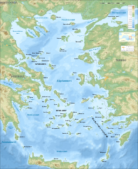
English: Bathymetric map in Finnish of the Aegean Sea, Mediterranean Sea.
Note: The background map is a raster image embedded in the SVG file. Français : Carte bathymétrique en finlandais de la Mer Égée, Mer Méditerranée.
Note : Le fond de carte est une image bitmap embarquée dans le fichier SVG.
|
| Date | November 2007 (modified September 2008) |
| Source |
Own work (Original text: Own work ;)
|
| Author | Eric Gaba (Sting - fr:Sting), translated by QWerk |
| Permission (Reusing this file) |
Attribution and Share-Alike required |
| Other versions |
[]
Same map but full SVG and without relief and bathymetry:
|
| SVG development |


Licensing[edit]
Eric Gaba, the copyright holder of this work, hereby publishes it under the following licenses:

|
Permission is granted to copy, distribute and/or modify this document under the terms of the GNU Free Documentation License, Version 1.2 or any later version published by the Free Software Foundation; with no Invariant Sections, no Front-Cover Texts, and no Back-Cover Texts. A copy of the license is included in the section entitled GNU Free Documentation License. |
This file is licensed under the Creative Commons Attribution-Share Alike 4.0 International, 3.0 Unported, 2.5 Generic, 2.0 Generic and 1.0 Generic license.
Attribution: Eric Gaba
- You are free:
- to share – to copy, distribute and transmit the work
- to remix – to adapt the work
- Under the following conditions:
- attribution – You must give appropriate credit, provide a link to the license, and indicate if changes were made. You may do so in any reasonable manner, but not in any way that suggests the licensor endorses you or your use.
- share alike – If you remix, transform, or build upon the material, you must distribute your contributions under the same or compatible license as the original.
You may select the license of your choice.
File history
Click on a date/time to view the file as it appeared at that time.
| Date/Time | Thumbnail | Dimensions | User | Comment | |
|---|---|---|---|---|---|
| current | 12:47, 29 September 2008 | | 3,750 × 4,560 (3.52 MB) | Sting (talk | contribs) | Completely new background using ETOPO1 data ; new standard colors |
| 20:57, 1 December 2007 |  | 3,750 × 4,560 (3.85 MB) | QWerk (talk | contribs) | == Summary == {{Information |Description=Bathymetric map in French of the Aegean Sea, Mediterranean Sea |Source=Own work ;<br/>Raster relief background map : [http://www2.jpl.nasa.gov/srtm NASA Shuttle Radar Topography Mission] (S |
You cannot overwrite this file.
File usage on Commons
The following 10 pages use this file:
- File:Aegean Sea map-de.png
- File:Aegean Sea map-de.svg
- File:Aegean Sea map-fr.svg
- File:Aegean Sea map-it.svg
- File:Aegean Sea map bathymetry-fi.svg
- File:Aegean Sea map bathymetry-fr.jpg
- File:Aegean Sea map bathymetry-fr.svg
- File:Aegean Sea map bathymetry-it.svg
- File:Aegean Sea map bathymetry.svg
- Template:Other versions/Aegean Sea map bathymetry
File usage on other wikis
The following other wikis use this file:
- Usage on fi.wikipedia.org