File:Annotated aerial photograph of Hughes Airport (HUS).jpg
Jump to navigation
Jump to search
No higher resolution available.
Annotated_aerial_photograph_of_Hughes_Airport_(HUS).jpg (574 × 384 pixels, file size: 58 KB, MIME type: image/jpeg)
Captions
Captions
Add a one-line explanation of what this file represents
Summary[edit]
.jpg&action=edit§ion=1)
| Description |
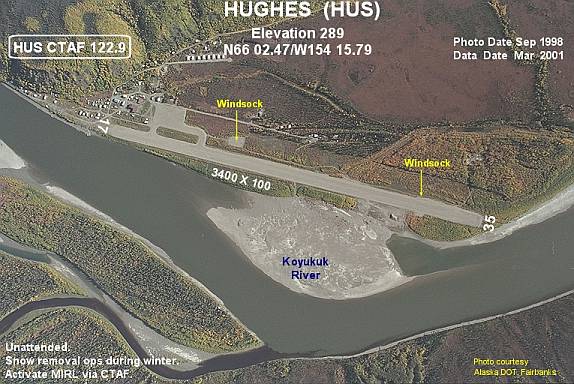
English: Annotated aerial photograph of Hughes Airport (HUS) in Hughes, Alaska, United States. |
| Date | Photo: September 1998; Data: March 2001 |
| Source |
Image: http://www.alaska.faa.gov/fai/images/KOYUKOB/HUS-i.jpg Web site: http://www.alaska.faa.gov/fai/airports.htm |
| Author | Federal Aviation Administration, Alaskan Region |
| Permission (Reusing this file) |
Public domain |
| Camera location | | View this and other nearby images on: OpenStreetMap |
|---|
.jpg¶ms=066.039167_N_-154.264722_E_globe:Earth_type:camera_region:US-AK_type:airport_&language=en)
Licensing[edit]
.jpg&action=edit§ion=2)
This image or file is a work of a Federal Aviation Administration employee, taken or made as part of that person's official duties. As a work of the U.S. federal government, the image is in the public domain in the United States.
|
 |
File history
Click on a date/time to view the file as it appeared at that time.
| Date/Time | Thumbnail | Dimensions | User | Comment | |
|---|---|---|---|---|---|
| current | 06:07, 18 September 2008 | | 574 × 384 (58 KB) | Zyxw (talk | contribs) | {{Information |Description = {{en|1=Annotated aerial photograph of Hughes Airport (HUS) in Hughes, Alaska, United States.}} |Source = Image: http://www.alaska.faa.gov/fai/images/KOYUKOB/HUS-i.jpg<br />Web site: http://www.alaska.faa |
You cannot overwrite this file.
File usage on Commons
The following 3 pages use this file:
- File:HUS-i.jpg (file redirect)
- Category:Hughes, Alaska
- Category:Hughes Airport (Alaska)
File usage on other wikis
The following other wikis use this file:
- Usage on ar.wikipedia.org
- Usage on arz.wikipedia.org
- Usage on ca.wikipedia.org
- Usage on ceb.wikipedia.org
- Usage on ce.wikipedia.org
- Usage on en.wikipedia.org
- Usage on es.wikipedia.org
- Usage on eu.wikipedia.org
- Usage on fa.wikipedia.org
- Usage on fr.wikipedia.org
- Usage on ht.wikipedia.org
- Usage on it.wikipedia.org
- Usage on lld.wikipedia.org
- Usage on ml.wikipedia.org
- Usage on no.wikipedia.org
- Usage on pl.wikipedia.org
- Usage on pt.wikipedia.org
- Usage on ru.wikipedia.org
- Usage on sr.wikipedia.org
- Usage on tg.wikipedia.org
- Usage on tt.wikipedia.org
- Usage on uk.wikipedia.org
- Usage on uz.wikipedia.org
- Usage on www.wikidata.org
.jpg&oldid=796072286)