File:Antarctic profile hg.png
Jump to navigation
Jump to search

Size of this preview: 800 × 574 pixels. Other resolutions: 320 × 230 pixels | 640 × 460 pixels | 1,024 × 735 pixels | 1,078 × 774 pixels.
Original file (1,078 × 774 pixels, file size: 191 KB, MIME type: image/png)
Captions
Captions
Add a one-line explanation of what this file represents
| Description |
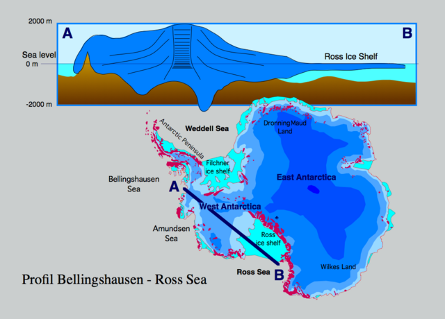
Profile through the Antarctic ice sheet (A) Bellingshausen Sea - West Antarctic ice sheet - Ross ice shelf - Ross Sea (B). The profile shows that most of the West Antarctic ice sheet is grounded below sea level which makes it sensitive to sea level rise. If the contact of the ice to the bottom rocks is lost seaward of the grounding line, the ice sheet becomes significantly thinner (some 100 m), forming a shelf ice.
|
| Date | |
| Source | Own work |
| Author | Hannes Grobe 21:51, 12 August 2006 (UTC), Alfred Wegener Institute for Polar and Marine Research, Bremerhaven, Germany |
| Permission (Reusing this file) |
Own work, share alike, attribution required (Creative Commons CC-BY-SA-2.5) |
I, the copyright holder of this work, hereby publish it under the following license:
This file is licensed under the Creative Commons Attribution-Share Alike 2.5 Generic license.
- You are free:
- to share – to copy, distribute and transmit the work
- to remix – to adapt the work
- Under the following conditions:
- attribution – You must give appropriate credit, provide a link to the license, and indicate if changes were made. You may do so in any reasonable manner, but not in any way that suggests the licensor endorses you or your use.
- share alike – If you remix, transform, or build upon the material, you must distribute your contributions under the same or compatible license as the original.
File history
Click on a date/time to view the file as it appeared at that time.
| Date/Time | Thumbnail | Dimensions | User | Comment | |
|---|---|---|---|---|---|
| current | 14:39, 22 November 2023 | | 1,078 × 774 (191 KB) | Rémih (talk | contribs) | Cropped 7 % horizontally, 4 % vertically using CropTool with precise mode. |
| 21:51, 12 August 2006 |  | 1,155 × 806 (198 KB) | Hgrobe (talk | contribs) | {{Information| |Description=Profile through the Antarctic ice sheet from the Ross Sea - Ross ice shelf - West Antarctic ice sheet - Bellingshausen Sea |Source=own work |Date=2006-08-08 |Author=~~~~ |Permission=Own work, share alike, attribution required ( |
You cannot overwrite this file.
File usage on Commons
The following 5 pages use this file:
File usage on other wikis
The following other wikis use this file:
- Usage on ceb.wikipedia.org
- Usage on el.wikipedia.org
- Usage on en.wikipedia.org
- Usage on es.wikipedia.org
- Usage on fr.wikipedia.org
- Usage on hu.wikipedia.org
- Usage on nl.wikipedia.org
- Usage on nn.wikipedia.org
- Usage on pl.wikipedia.org
- Usage on ru.wikipedia.org
- Usage on uk.wikipedia.org
- Usage on www.wikidata.org