File:Arnhem Trolley 2013.png
Jump to navigation
Jump to search

Size of this preview: 800 × 570 pixels. Other resolutions: 320 × 228 pixels | 640 × 456 pixels | 1,024 × 729 pixels | 1,280 × 911 pixels | 2,560 × 1,823 pixels | 4,110 × 2,926 pixels.
Original file (4,110 × 2,926 pixels, file size: 191 KB, MIME type: image/png)
Captions
Captions
Add a one-line explanation of what this file represents
Summary[edit]
| Description |
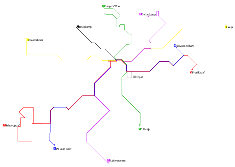
English: Map of the Trolleybus-network in Arnhem (NL) from December 9th 2012 to December 14th 2014.
Nederlands: Kaart van het trolleybus-netwerk te Arnhem (NL), zoals dat gegolden heeft van 9 december 2012 tot aan 14 december 2014. |
| Date | |
| Source | Own work |
| Author | GR113 |
Licensing[edit]
I, the copyright holder of this work, hereby publish it under the following licenses:

|
Permission is granted to copy, distribute and/or modify this document under the terms of the GNU Free Documentation License, Version 1.2 or any later version published by the Free Software Foundation; with no Invariant Sections, no Front-Cover Texts, and no Back-Cover Texts. A copy of the license is included in the section entitled GNU Free Documentation License. |
This file is licensed under the Creative Commons Attribution-Share Alike 3.0 Unported, 2.5 Generic, 2.0 Generic and 1.0 Generic license.
- You are free:
- to share – to copy, distribute and transmit the work
- to remix – to adapt the work
- Under the following conditions:
- attribution – You must give appropriate credit, provide a link to the license, and indicate if changes were made. You may do so in any reasonable manner, but not in any way that suggests the licensor endorses you or your use.
- share alike – If you remix, transform, or build upon the material, you must distribute your contributions under the same or compatible license as the original.
You may select the license of your choice.
File history
Click on a date/time to view the file as it appeared at that time.
| Date/Time | Thumbnail | Dimensions | User | Comment | |
|---|---|---|---|---|---|
| current | 09:51, 17 September 2022 | | 4,110 × 2,926 (191 KB) | Cornepronk (talk | contribs) | Reverted to version as of 18:22, 6 December 2012 (UTC) |
| 15:55, 8 July 2013 |  | 4,265 × 2,726 (3.27 MB) | LEGO (talk | contribs) | Minder lijnaanduiding | |
| 15:54, 8 July 2013 |  | 4,265 × 2,726 (3.27 MB) | LEGO (talk | contribs) | Minder lijnaanduiding | |
| 15:05, 9 January 2013 |  | 4,265 × 2,726 (3.42 MB) | LEGO (talk | contribs) | Update goede lijnkleur | |
| 04:46, 3 January 2013 |  | 4,265 × 2,721 (3.42 MB) | LEGO (talk | contribs) | Kleuren op de bus | |
| 03:42, 3 January 2013 |  | 4,265 × 2,721 (3.35 MB) | LEGO (talk | contribs) | Uitgebreider | |
| 22:29, 2 January 2013 |  | 1,275 × 814 (632 KB) | LEGO (talk | contribs) | Modernere versie | |
| 18:22, 6 December 2012 |  | 4,110 × 2,926 (191 KB) | GR113 (talk | contribs) | Made the number of line 1 readable. | |
| 02:10, 6 December 2012 |  | 4,165 × 2,926 (192 KB) | GR113 (talk | contribs) | {{Information |Description ={{en|1=Map of the Trolleybus-network in Arnhem (NL) from December 9th 2012.}} {{nl|1=Kaart van het trolleybus-netwerk te Arnhem (NL) geldende vanaf 9 december 2012.}} |Source ={{own}} |Author =[[User:GR113... |
You cannot overwrite this file.
File usage on Commons
There are no pages that use this file.