File:Athabasca oil sand mining map 2011.jpg
Jump to navigation
Jump to search

Size of this preview: 800 × 502 pixels. Other resolutions: 320 × 201 pixels | 640 × 402 pixels | 1,024 × 643 pixels | 1,280 × 804 pixels | 2,560 × 1,607 pixels | 4,189 × 2,630 pixels.
Original file (4,189 × 2,630 pixels, file size: 3.62 MB, MIME type: image/jpeg)
Captions
Captions
Add a one-line explanation of what this file represents
Summary[edit]
| Description |
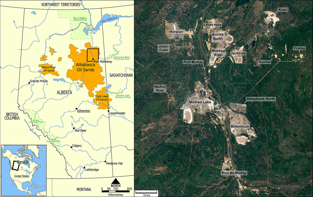
English: Map of Alberta showing extension of oil sand occurences (left) and annotated satellite image (right) with oil sand open-cast mines and in-situ production sites along the Athabasca River north of Fort McMurray. The satellite image shows the situation in 2011. The photographed area ist the only place in Alberta in which oil sands are mined in open pits. All other oil sand bitumen production sites are utilizing (mainly steam-based) in-situ methods (SAGD, CSS).
Deutsch: Karte von Alberta mit Erstreckung der Ölsandvorkommen (links) und beschriftete Satellitenaufnahme (rechts) mit Tagebauen und In-Situ-Förderanlagen entlang dem Athabasca River nördlich von Fort McMurray. Das Satellitenbild zeigt die Situation im Jahre 2011. Das fotografierte Areal ist das einzige Gebiet in Alberta, in dem der Ölsand im Tagebau gefördert wird. Alle anderen Ölsand-Bitumenförderanlagen nutzen (überwiegend auf Dampf basierende) In-situ-Methoden (SAGD, CSS). |
| Date | |
| Source |
This file was derived from: |
| Author | Gretarsson |
Licensing[edit]
I, the copyright holder of this work, hereby publish it under the following license:
| This file is made available under the Creative Commons CC0 1.0 Universal Public Domain Dedication. | |
| The person who associated a work with this deed has dedicated the work to the public domain by waiving all of their rights to the work worldwide under copyright law, including all related and neighboring rights, to the extent allowed by law. You can copy, modify, distribute and perform the work, even for commercial purposes, all without asking permission.
|
File history
Click on a date/time to view the file as it appeared at that time.
| Date/Time | Thumbnail | Dimensions | User | Comment | |
|---|---|---|---|---|---|
| current | 01:49, 31 May 2015 | | 4,189 × 2,630 (3.62 MB) | Gretarsson (talk | contribs) | {{Information |Description ={{en|1=Map of Alberta showing extension of oil sand occurences (left) and annotated satellite image (right) with oil sand open-cast mines and in-situ production sites north of Fort McMurray.}} {{de|1=Karte von Alberta mit... |
You cannot overwrite this file.
File usage on Commons
The following 6 pages use this file:
File usage on other wikis
The following other wikis use this file:
- Usage on ar.wikipedia.org
- Usage on de.wikipedia.org
- Usage on uk.wikipedia.org
- Usage on www.wikidata.org