File:Atlas of New Jersey - Counties of Essex, Union, and Hudson. NYPL1692351.tiff
Jump to navigation
Jump to search

Size of this JPG preview of this TIF file: 799 × 600 pixels. Other resolutions: 320 × 240 pixels | 640 × 480 pixels | 1,023 × 768 pixels | 1,280 × 961 pixels | 2,560 × 1,922 pixels | 7,230 × 5,428 pixels.
Original file (7,230 × 5,428 pixels, file size: 112.28 MB, MIME type: image/tiff)
Captions
Captions
Add a one-line explanation of what this file represents
Summary[edit]
| Description | Atlas of New Jersey : Counties of Essex, Union, and Hudson.; Atlases of the United States / New Jersey / Combined atlas of the State of New Jersey and the County of Hudson : from actual survey, official records and private plans / by and under the direction of G. M. Hopkins ... | |||||||||||||||||||||||||
| Catalogue call number | Map Div.++ (Hudson county, N.J.) (Hopkins, G. M. Company, Philadelphia. Combined atlas of the state of New Jersey, and the county of Hudson) | |||||||||||||||||||||||||
| Item/Page/Plate | 27 | |||||||||||||||||||||||||
| Date | ||||||||||||||||||||||||||
| Source |
http://digitalgallery.nypl.org/nypldigital/dgkeysearchdetail.cfm?imageID=1692351
|
|||||||||||||||||||||||||
| Author |
|
|||||||||||||||||||||||||
| Permission (Reusing this file) |
From The Lionel Pincus and Princess Firyal Map Division. http://maps.nypl.org
|
|||||||||||||||||||||||||
| Source description | 163 p. : 53 col. maps ; 45 cm. | |||||||||||||||||||||||||
| Location | Stephen A. Schwarzman Building / The Lionel Pincus and Princess Firyal Map Division | |||||||||||||||||||||||||
| Digital item published | 1-23-2009; updated 3-25-2011 | |||||||||||||||||||||||||
| Digital ID | 1692351 | |||||||||||||||||||||||||

The making of this file was supported by Wikimedia UK.
To see other files made with the support of Wikimedia UK, please see the category Supported by Wikimedia UK.
|
File history
Click on a date/time to view the file as it appeared at that time.
| Date/Time | Thumbnail | Dimensions | User | Comment | |
|---|---|---|---|---|---|
| current | 23:26, 20 April 2014 | 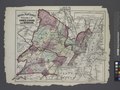 | 7,230 × 5,428 (112.28 MB) | Fæ (talk | contribs) | GWToolset:: Creating mediafile for Fæ. Tranche 2.2191 |
You cannot overwrite this file.
File usage on Commons
There are no pages that use this file.