File:B-17 Plane Crash over the Pacific on August 17, 1947.ja.svg
Jump to navigation
Jump to search

Size of this PNG preview of this SVG file: 557 × 301 pixels. Other resolutions: 320 × 173 pixels | 640 × 346 pixels | 1,024 × 553 pixels | 1,280 × 692 pixels | 2,560 × 1,383 pixels.
Original file (SVG file, nominally 557 × 301 pixels, file size: 94 KB)
Captions
Captions
Add a one-line explanation of what this file represents
| Description |
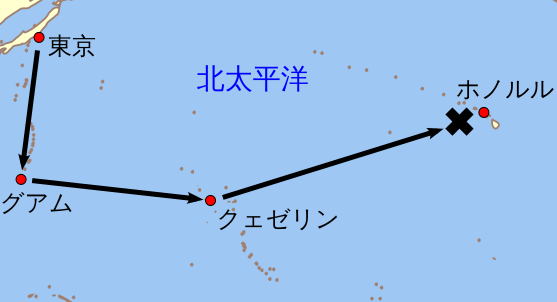
English: An orthographic projection of the pacific ocean, showing land outlines (resolution ~0.5 degrees) and the Polynesian triangle between Hawai'i, Rapa Nui and Aotearoa. Created using a custom perl script (http://user.interface.org.nz/~gringer/hacking/wdb2svg.txt, rename to .pl) to convert wdb2 vector data (from http://www.evl.uic.edu/pape/data/WDB/) into an SVG file (including combining segments into longer paths). Some tweaking was then done in Inkscape to fix up vector location errors, combine paths, then colour as suggested in Wikipedia:WikiProject_Maps/Conventions. |
| Date | (UTC) |
| Source | |
| Author |
|
| Other versions |
|

| This is a retouched picture, which means that it has been digitally altered from its original version. The original can be viewed here: Polynesian triangle.svg:
|
This file is licensed under the Creative Commons Attribution 3.0 Unported license.
- You are free:
- to share – to copy, distribute and transmit the work
- to remix – to adapt the work
- Under the following conditions:
- attribution – You must give appropriate credit, provide a link to the license, and indicate if changes were made. You may do so in any reasonable manner, but not in any way that suggests the licensor endorses you or your use.
Original upload log[edit]
This image is a derivative work of the following images:
- File:Polynesian_triangle.svg licensed with Cc-by-3.0
- 2009-11-24T03:01:49Z Gringer 542x542 (91941 Bytes) {{Information |Description={{en|1=An orthographic projection of the pacific ocean, showing land outlines (resolution ~0.5 degrees) and the Polynesian triangle between Hawai'i, Rapa Nui and Aotearoa. Created using a custom per
Uploaded with derivativeFX
File history
Click on a date/time to view the file as it appeared at that time.
| Date/Time | Thumbnail | Dimensions | User | Comment | |
|---|---|---|---|---|---|
| current | 06:52, 21 February 2010 | | 557 × 301 (94 KB) | Miyamaki (talk | contribs) | 表示エリアからはみ出した文字列の位置を修正 |
| 06:50, 21 February 2010 |  | 557 × 301 (94 KB) | Miyamaki (talk | contribs) | 文字列を訂正 | |
| 06:30, 21 February 2010 |  | 557 × 301 (99 KB) | Miyamaki (talk | contribs) | {{Information |Description={{en|1=An orthographic projection of the pacific ocean, showing land outlines (resolution ~0.5 degrees) and the Polynesian triangle between Hawai'i, Rapa Nui and Aotearoa. Created using a custom perl script (http://user.interfac |
You cannot overwrite this file.
File usage on Commons
The following page uses this file:
File usage on other wikis
The following other wikis use this file:
- Usage on ja.wikipedia.org