File:BHDetail.jpg
Jump to navigation
Jump to search

Size of this preview: 776 × 600 pixels. Other resolutions: 311 × 240 pixels | 621 × 480 pixels | 994 × 768 pixels | 1,280 × 989 pixels | 2,560 × 1,978 pixels | 3,300 × 2,550 pixels.
Original file (3,300 × 2,550 pixels, file size: 1.73 MB, MIME type: image/jpeg)
Captions
Captions
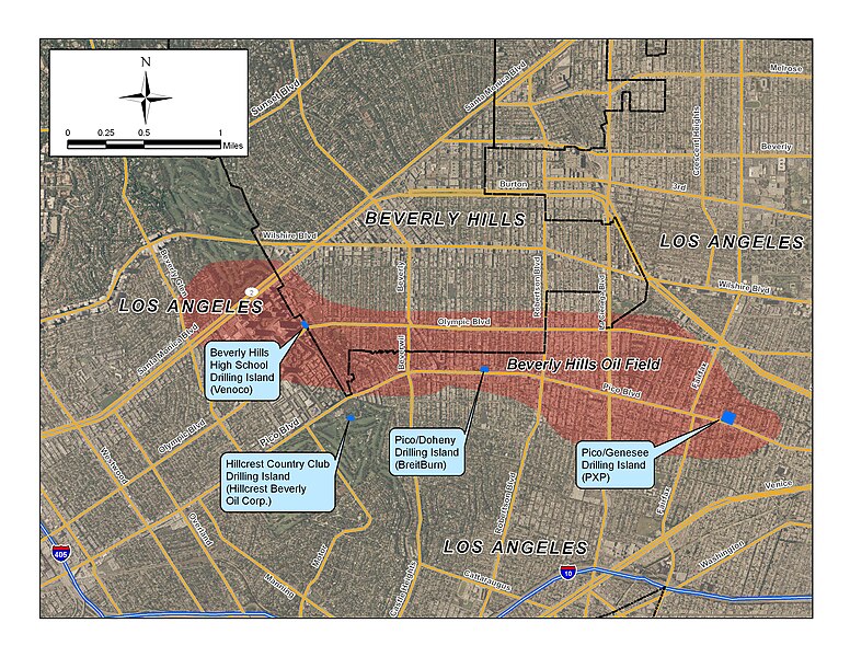
Beverly Hills Oil Field detail, showing drilling islands
Summary[edit]
| Description |
English: Beverly Hills Oil Field detail, showing drilling islands. Oil field boundaries from California Department of Conservation. Map projection California State Plane Zone V NAD 83. NOTE: THE LOCATION OF THE ACTUAL OIL FIELD MIGHT BE ACCURATE HOWEVER LAND AREAS EFFECTED EXTEND FURTHER NORTH, TO AT LEAST THE 200 BLOCK SOUTH OF WILSHIRE BLVD, ACCORDING TO THE VARIOUS EXHIBITS CONTAINING RESTRICTIONS, CONDITIONS AND DISCLOSURES ON TITLES/DEEDS FOR THE REAL PROPERTY LOCATED THERE. |
| Date | 27 August 2009 (original upload date); 31 August 2009 (last version) |
| Source |
Own work (Original caption: " Created by uploader in ArcGIS 9.3, 8/27/09. Source data public domain (US Census; NAIP aerial photo). ")Transferred from en.wikipedia to Commons by User:Matthiasb using CommonsHelper. |
| Author | Antandrus at en.wikipedia |
Licensing[edit]
Antandrus at en.wikipedia, the copyright holder of this work, hereby publishes it under the following licenses:
This file is licensed under the Creative Commons Attribution-Share Alike 3.0 Unported license.
Attribution: Antandrus at en.wikipedia
- You are free:
- to share – to copy, distribute and transmit the work
- to remix – to adapt the work
- Under the following conditions:
- attribution – You must give appropriate credit, provide a link to the license, and indicate if changes were made. You may do so in any reasonable manner, but not in any way that suggests the licensor endorses you or your use.
- share alike – If you remix, transform, or build upon the material, you must distribute your contributions under the same or compatible license as the original.

|
Permission is granted to copy, distribute and/or modify this document under the terms of the GNU Free Documentation License, Version 1.2 or any later version published by the Free Software Foundation; with no Invariant Sections, no Front-Cover Texts, and no Back-Cover Texts. A copy of the license is included in the section entitled GNU Free Documentation License. |
You may select the license of your choice.
Original upload log[edit]
The original description page was here. All following user names refer to en.wikipedia.
- 2009-08-31 23:59 Antandrus 3300×2550× (1813618 bytes) Uploading improved version (typo fixed, one location corrected). Map by uploader in ArcGIS 9.3. All data shown is in the public domain. * 2009-08-27 23:59 Antandrus 3300×2550× (1814549 bytes) Beverly Hills Oil Field detail, showing drilling islands. Created by uploader in ArcGIS 9.3, 8/27/09. Source data public domain (US Census; NAIP aerial photo)
File history
Click on a date/time to view the file as it appeared at that time.
| Date/Time | Thumbnail | Dimensions | User | Comment | |
|---|---|---|---|---|---|
| current | 13:20, 6 July 2011 | | 3,300 × 2,550 (1.73 MB) | OgreBot (talk | contribs) | (BOT): Reverting to the most recent version before uploads (originally uploaded on 2009-08-31 23:59 by Antandrus). |
| 13:19, 6 July 2011 |  | 3,300 × 2,550 (1.73 MB) | OgreBot (talk | contribs) | (BOT): This is the version originally uploaded on 2009-08-27 23:59 by Antandrus; storing on commons for archival purposes | |
| 11:06, 6 July 2011 |  | 3,300 × 2,550 (1.73 MB) | Matthiasb (talk | contribs) | {{Information |Description={{en|Beverly Hills Oil Field detail, showing drilling islands. Created by uploader in ArcGIS 9.3, 8/27/09. Source data public domain (US Census; NAIP aerial photo). Oil field boundaries from California Department of Conservat |
You cannot overwrite this file.
File usage on Commons
There are no pages that use this file.
File usage on other wikis
The following other wikis use this file:
- Usage on de.wikipedia.org
- Usage on en.wikipedia.org