File:BOAT TUNNEL AND NAVIGATION LOCK FROM THE MERRIMACK RIVER INTO THE NORTHERN CANAL. VIEW IS LOOKING NORTHEAST TO THE CANAL- Jack Boucher, Photographrer 1976 - Northern Canal, HAER MASS,9-LOW,15-6.tif
Jump to navigation
Jump to search

Size of this JPG preview of this TIF file: 800 × 574 pixels. Other resolutions: 320 × 230 pixels | 640 × 459 pixels | 1,024 × 735 pixels | 1,280 × 919 pixels | 2,560 × 1,838 pixels | 5,000 × 3,589 pixels.
Original file (5,000 × 3,589 pixels, file size: 17.12 MB, MIME type: image/tiff)
Captions
Captions
Add a one-line explanation of what this file represents
Summary[edit]
| BOAT TUNNEL AND NAVIGATION LOCK FROM THE MERRIMACK RIVER INTO THE NORTHERN CANAL. VIEW IS LOOKING NORTHEAST TO THE CANAL- Jack Boucher, Photographrer 1976 - Northern Canal, Pawtucket and Ford Streets vicinity, Lowell, Middlesex County, MA
( |
||||||||||||||||||||||||||
|---|---|---|---|---|---|---|---|---|---|---|---|---|---|---|---|---|---|---|---|---|---|---|---|---|---|---|
| Photographer |
|
|||||||||||||||||||||||||
| Title |
BOAT TUNNEL AND NAVIGATION LOCK FROM THE MERRIMACK RIVER INTO THE NORTHERN CANAL. VIEW IS LOOKING NORTHEAST TO THE CANAL- Jack Boucher, Photographrer 1976 - Northern Canal, Pawtucket and Ford Streets vicinity, Lowell, Middlesex County, MA |
|||||||||||||||||||||||||
| Description |
Proprietors of the Locks and Canals on the Merrimack River; Francis, James B; Hawley, Monica E, transmitter; Malone, Patrick M, historian; Boucher, Jack, photographer |
|||||||||||||||||||||||||
| Depicted place | Massachusetts; Middlesex County; Lowell | |||||||||||||||||||||||||
| Date | Documentation compiled after 1968 | |||||||||||||||||||||||||
| Dimensions | 5 x 7 in. | |||||||||||||||||||||||||
| Current location |
Library of Congress Prints and Photographs Division Washington, D.C. 20540 USA http://hdl.loc.gov/loc.pnp/pp.print |
|||||||||||||||||||||||||
| Accession number |
HAER MASS,9-LOW,15-6 |
|||||||||||||||||||||||||
| Credit line |
|
|||||||||||||||||||||||||
| Notes |
|
|||||||||||||||||||||||||
| Source | https://www.loc.gov/pictures/item/ma0547.photos.080546p | |||||||||||||||||||||||||
| Permission (Reusing this file) |
|
|||||||||||||||||||||||||

| Object location | | View this and other nearby images on: OpenStreetMap |
|---|
File history
Click on a date/time to view the file as it appeared at that time.
| Date/Time | Thumbnail | Dimensions | User | Comment | |
|---|---|---|---|---|---|
| current | 23:18, 20 July 2014 | 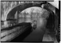 | 5,000 × 3,589 (17.12 MB) | Fæ (talk | contribs) | GWToolset: Creating mediafile for Fæ. HABS 20 July 2014 (1401:1600) |
You cannot overwrite this file.
File usage on Commons
The following page uses this file:
Metadata
Categories:
- Canal tunnels in the United States
- Pawtucket Gatehouse
- Buildings in Lowell, Massachusetts
- Black and white photographs of structures in Massachusetts
- Black and white photographs of Lowell, Massachusetts
- Historic American Engineering Record images of Lowell, Massachusetts
- 1976 in Massachusetts
- Canals in Lowell, Massachusetts