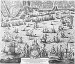
File:Balthasar Florisz. van Berckenrode - Amsterdam (1625) 3-1.jpg

Original file (2,500 × 2,168 pixels, file size: 3.93 MB, MIME type: image/jpeg)
Captions
Captions
Summary[edit]
| Map of Amsterdam (bottom left leaf), 1625.
|
|||||||||||||||||||||||||||||||||||||||||||||||||||||
|---|---|---|---|---|---|---|---|---|---|---|---|---|---|---|---|---|---|---|---|---|---|---|---|---|---|---|---|---|---|---|---|---|---|---|---|---|---|---|---|---|---|---|---|---|---|---|---|---|---|---|---|---|---|
| Author |
creator QS:P170,Q4356567
creator QS:P170,Q2063138
|
||||||||||||||||||||||||||||||||||||||||||||||||||||
| Title |
Map of Amsterdam (bottom left leaf), 1625. label QS:Len,"Map of Amsterdam (bottom left leaf), 1625."
label QS:Lnl,"Plattegrond van Amsterdam (blad linksonder), 1625." |
||||||||||||||||||||||||||||||||||||||||||||||||||||
| Object type |
map |
||||||||||||||||||||||||||||||||||||||||||||||||||||
| Description |
Nederlands: Grote plattegrond van de stad Amsterdam uit 1625. Linksboven een gezicht op de stad en rechtsboven een kaart van de omgeving. Rechts een lijst met de namen van straten aan de Oude en de Nieuwe stadszijde. De plattegrond is samengesteld uit negen platen, waarvan twee ontbreken. Dit is het blad linksonder met de haven en het IJ en een gedicht op de stad Amsterdam door Petrus Scriverius. |
||||||||||||||||||||||||||||||||||||||||||||||||||||
| Date |
1625 date QS:P571,+1625-00-00T00:00:00Z/9 |
||||||||||||||||||||||||||||||||||||||||||||||||||||
| Medium | etching print on paper | ||||||||||||||||||||||||||||||||||||||||||||||||||||
| Dimensions |
height: 46 cm (18.1 in); width: 53.5 cm (21 in) dimensions QS:P2048,46U174728 dimensions QS:P2049,53.5U174728 |
||||||||||||||||||||||||||||||||||||||||||||||||||||
| Collection |
institution QS:P195,Q190804 |
||||||||||||||||||||||||||||||||||||||||||||||||||||
| Current location |
Rijksprentenkabinet |
||||||||||||||||||||||||||||||||||||||||||||||||||||
| Accession number |
RP-P-1892-A-17491F |
||||||||||||||||||||||||||||||||||||||||||||||||||||
| Object history |
1892: purchased by the Rijksmuseum Amsterdam, Amsterdam |
||||||||||||||||||||||||||||||||||||||||||||||||||||
| Source/Photographer | www.rijksmuseum.nl : Home : Info : Pic | ||||||||||||||||||||||||||||||||||||||||||||||||||||
| Other versions |
   |
||||||||||||||||||||||||||||||||||||||||||||||||||||
Licensing[edit]
|
This is a faithful photographic reproduction of a two-dimensional, public domain work of art. The work of art itself is in the public domain for the following reason:
The official position taken by the Wikimedia Foundation is that "faithful reproductions of two-dimensional public domain works of art are public domain".
This photographic reproduction is therefore also considered to be in the public domain in the United States. In other jurisdictions, re-use of this content may be restricted; see Reuse of PD-Art photographs for details. | |||||
File history
Click on a date/time to view the file as it appeared at that time.
| Date/Time | Thumbnail | Dimensions | User | Comment | |
|---|---|---|---|---|---|
| current | 18:53, 12 May 2012 |  | 2,500 × 2,168 (3.93 MB) | Fentener van Vlissingen (talk | contribs) | {{Artwork |Description={{nl|Grote plattegrond van de stad Amsterdam uit 1625. Linksboven een gezicht op de stad en rechtsboven een kaart van de omgeving. Rechts een lijst met de namen van straten aan de Oude en de Nieuwe stadszijde. De plattegrond is s... |
You cannot overwrite this file.
File usage on Commons
The following 15 pages use this file:
- Balthasar Florisz. van Berckenrode
- Old maps of Amsterdam
- Rijksmuseum Amsterdam/Collection/Prints
- User:Fentener van Vlissingen/Balthasar
- User:Fentener van Vlissingen/Old maps of Amsterdam
- File:Balthasar Florisz. van Berckenrode - Amsterdam (1625) 1-1.jpg
- File:Balthasar Florisz. van Berckenrode - Amsterdam (1625) 1-2.jpg
- File:Balthasar Florisz. van Berckenrode - Amsterdam (1625) 1-3.jpg
- File:Balthasar Florisz. van Berckenrode - Amsterdam (1625) 2-1.jpg
- File:Balthasar Florisz. van Berckenrode - Amsterdam (1625) 2-2.jpg
- File:Balthasar Florisz. van Berckenrode - Amsterdam (1625) 2-3.jpg
- File:Balthasar Florisz. van Berckenrode - Amsterdam (1625) 3-1.jpg
- File:Balthasar Florisz. van Berckenrode - Amsterdam (1625) 3-2.jpg
- File:Balthasar Florisz. van Berckenrode - Amsterdam (1625) 3-3.jpg
- File:Oude Waal (1625).jpg
File usage on other wikis
The following other wikis use this file:
- Usage on www.wikidata.org
Metadata
This file contains additional information such as Exif metadata which may have been added by the digital camera, scanner, or software program used to create or digitize it. If the file has been modified from its original state, some details such as the timestamp may not fully reflect those of the original file. The timestamp is only as accurate as the clock in the camera, and it may be completely wrong.
| Copyright holder |
|
|---|---|
| Date and time of data generation | 09:07, 21 August 2009 |
| Lens focal length | 85 mm |
| ISO speed rating | 50 |
| Source | PKONLINE-R |
| Online copyright statement | www.rijksmuseum.nl |
| Width | 6,666 px |
| Height | 4,992 px |
| Bits per component |
|
| Compression scheme | Uncompressed |
| Pixel composition | RGB |
| Orientation | Normal |
| Number of components | 3 |
| Horizontal resolution | 350 dpi |
| Vertical resolution | 350 dpi |
| Data arrangement | chunky format |
| Software used | Adobe Photoshop CS4 Macintosh |
| File change date and time | 16:50, 27 August 2009 |
| Color space | Uncalibrated |
| Image width | 2,500 px |
| APEX exposure bias | 0 |
| APEX shutter speed | 6 |
| APEX aperture | 7.5 |
| Image height | 2,168 px |
| Exposure mode | Manual exposure |
| Urgency | 9 |
| Date and time of digitizing | 09:07, 21 August 2009 |
| Date metadata was last modified | 18:50, 27 August 2009 |
| Copyright status | Copyrighted |
| Unique ID of original document | xmp.did:4DC446B2472068118F628875094D4C54 |
Structured data
85 millimetre
image/jpeg
cd04f5eef36c739c43eebb0ada4c80b4d40c8588
4,116,653 byte
2,168 pixel
2,500 pixel
- Artworks with digital representation of different depicts
- Artworks with known accession number
- Artworks with Wikidata item
- Artworks with Wikidata item missing genre
- Artworks with Wikidata item missing author
- Artworks with Wikidata item missing medium
- Artworks digital representation of unknown type of work
- CC-PD-Mark
- PD-old-100-expired
- PD-Art (PD-old-100-expired)


