File:Barrington Hall, Roswell (Fulton County, Georgia).jpg
Jump to navigation
Jump to search
No higher resolution available.
Barrington_Hall,_Roswell_(Fulton_County,_Georgia).jpg (492 × 359 pixels, file size: 81 KB, MIME type: image/jpeg)
Captions
Captions
Add a one-line explanation of what this file represents
|
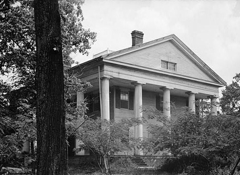
This is an image of a place or building that is listed on the National Register of Historic Places in the United States of America. Its reference number is 71000275. |
| Description |
English: Barrington Hall, Roswell (Fulton County, Georgia) - cropped |
|||||
| Date | ||||||
| Source | http://memory.loc.gov/cgi-bin/displayPhoto.pl?path=/pnp/habshaer/ga/ga0300/ga0316/photos&topImages=057242pr.jpg&topLinks=057242pv.jpg,057242pu.tif&title=1.%20%20Historic%20American%20Buildings%20Survey%20L.%20D.%20Andrew,%20Photographer%20Aug.%206,%201936%20VIEW%20OF%20FRONT%20AND%20RIGHT%20SIDE%20%20%3cbr%3eHABS%20GA,61-ROSW,5-1&displayProfile=0 | |||||
| Author | L. D. Andrew, Photographer | |||||
| Permission (Reusing this file) |
|

| Object location | | View this and other nearby images on: OpenStreetMap |
|---|
.jpg¶ms=034.013056_N_-084.363889_E_globe:Earth_class:object_region:US_type:landmark_scale:1500_&language=en)
File history
Click on a date/time to view the file as it appeared at that time.
| Date/Time | Thumbnail | Dimensions | User | Comment | |
|---|---|---|---|---|---|
| current | 14:14, 29 June 2009 | | 492 × 359 (81 KB) | KudzuVine (talk | contribs) | {{Information |Description={{en|1=Barrington Hall, Roswell (Fulton County, Georgia) - cropped {{HABS|GA,61-ROSW,5-1}} {{PD-USGov-Interior-HABS}}}} |Source=http://memory.loc.gov/cgi-bin/displayPhoto.pl?path=/pnp/habshaer/ga/ga0300/ga0316/photos&topImages= |
You cannot overwrite this file.
File usage on Commons
There are no pages that use this file.
File usage on other wikis
The following other wikis use this file:
- Usage on en.wikipedia.org
.jpg&oldid=817423929)