File:Belize-CIA WFB Map (2004).png
Jump to navigation
Jump to search

No higher resolution available.
Belize-CIA_WFB_Map_(2004).png (330 × 354 pixels, file size: 8 KB, MIME type: image/png)
Captions
Captions
Add a one-line explanation of what this file represents

|
This map image could be re-created using vector graphics as an SVG file. This has several advantages; see Commons:Media for cleanup for more information. If an SVG form of this image is available, please upload it and afterwards replace this template with
{{vector version available|new image name}}.
It is recommended to name the SVG file “Belize-CIA WFB Map (2004).svg”—then the template Vector version available (or Vva) does not need the new image name parameter. |
Summary[edit]
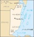
| Description | Belize map from CIA World Factbook (since 18 October 2000), converted from original GIF format |
| Date | |
| Source | CIA World Factbook |
| Author | United States Central Intelligence Agency |
| Other versions |
|
Derivative works[edit]
-
 Belize CIA map PL.png
polski -
 Belize-CIA WFB Map-hu.png
magyar -
 Belize-CIA WFB Map-hu.png
italiano -
 Bh-map-ja.png
日本語 -
 Belize-map-blank.png


.png&action=edit§ion=1)
.png&action=edit§ion=2)
Licensing[edit]
.png&action=edit§ion=3)
This image is in the public domain because it contains materials that originally came from the United States Central Intelligence Agency's World Factbook.
|
 |
File history
Click on a date/time to view the file as it appeared at that time.
| Date/Time | Thumbnail | Dimensions | User | Comment | |
|---|---|---|---|---|---|
| current | 15:34, 14 April 2009 | | 330 × 354 (8 KB) | Spangineer (talk | contribs) | {{original|Belize-CIA WFB Map.png|2004 version}} {{CIA-map}} Category:Maps of Belize <!--{{ImageUpload|basic}}--> |
You cannot overwrite this file.
File usage on Commons
The following page uses this file:
File usage on other wikis
The following other wikis use this file:
- Usage on cy.wikipedia.org
.png&oldid=820573920)